


Summary
Khndzoresk (Armenian: Խնձորեսկ, pronounced [χəndzɔˈɾɛsk]) is a village in the Goris Municipality of the Syunik Province in Armenia. The village is located to the east of the Goris-Stepanakert highway, on the steep slopes of Khor Dzor (Deep Gorge), which the village is named after, according to tradition.
Khndzoresk
Խնձորեսկ | |
|---|---|
 | |
 Khndzoresk  Khndzoresk | |
| Coordinates: 39°30′44″N 46°26′01″E / 39.51222°N 46.43361°E | |
| Country | |
| Province | Syunik |
| Municipality | Goris |
| Area | |
| • Total | 67.86 km2 (26.20 sq mi) |
| Population | |
| • Total | 2,070 |
| • Density | 31/km2 (79/sq mi) |
| Time zone | UTC+4 (AMT) |
Crossing the bridge at the entrance of the village, the road continues towards the towns of Lachin and Stepanakert. New Khndzoresk (the current inhabited area) was built in the 1950s. The village is located at 1,580 m (5,180 ft) above sea level and occupies 6,772.8 ha (26.150 sq mi).
History edit
In the end of the 19th century, Old Khndzoresk was the biggest village of Eastern Armenia. In the beginning of the 20th century the community had 8,300 inhabitants (1,800 households). In 1913 there were 27 shops, 3 dye-houses, tanneries, 7 schools. The village is famous for taking part in the liberation movement of David Bek. The fortress of Khndzoresk served as a military base for Mkhitar Sparapet in 1728–1730. In 1735 the village was visited by Catholicos (Head of Armenian Apostolic Church) Abraham Kretatsi who gave a thorough description of the community in his chronicles. During the 1980s, an additional village sprouted 7 km (4.3 mi) from Khndzoresk due to resizing and political unrest. This village, considerably smaller than Khndzoresk, is called Lower Khndzoresk, or Nerkin Khndzoresk.[3]
Cultural heritage edit
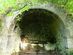
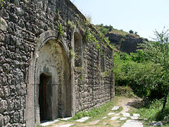
Khndzoresk is widely famous for its canyon with picturesque rock formations and ancient cave settlement. The artificial caves, some of which are currently used as stables and warehouses, used to be inhabited till the 1950s. In the bottom of the gorge there is St. Hripsime church, dating back to the 17th century. On a spur beyond on the right side of the gorge there is Anapat (hermitage) with the tomb of Mkhitar Sparapet. The cave church of St. Tatevos can also be found nearby.[3]
Economy and culture edit
About 90% of the population is engaged in agriculture and animal husbandry. There is a small milk processing enterprise, employing 8 people. The community has a number of administrative and public institutions, such as a community council, a secondary school (with 370 pupils), a musical school, a kindergarten, a library, a museum and a culture club.[4]
Demographics edit
In the 1823 survey of the province of Karabakh completed by Russian general Aleksey Petrovich Yermolov, Khndzoresk, mentioned as was Khinzyrak, was recorded as an Armenian village consisting of 170 tax-paying households, headed by the Armenian Melik Husein Ali.[5] According to the 1897 census, Khndzoresk—mentioned as Khinzirak (Russian: Хинзиракъ)—had a population of 4,516, all Armenian Apostolics. The village had 2,295 men and 2,221 women.[6]
The National Statistical Service of the Republic of Armenia (ARMSTAT) reported its population as 2,260 in 2010,[7] up from 1,992 at the 2001 census.[8] In 2009, the population of Khndzoresk comprised 2256 people, of which 1126 were women and 1130 were men. There were 516 households in total.
The population of Khndzoresk since 1831 is as follows:[9]
| Year | Population | Note |
|---|---|---|
| 1831 | 1,342 | 1,322 Armenians, 20 Muslims |
| 1873 | 3,369 | 100% Armenian |
| 1886 | 4,219 | |
| 1897 | 4,516 | 100% Armenian Apostolic; 2,295 men. |
| 1904 | 7,059 | |
| 1914 | 8,335 | Mainly Armenian |
| 1916 | 3,710 | |
| 1919 | 4,550 | Mainly Armenian |
| 1922 | 3,505 | 100% Armenian |
| 1926 | 2,596 | 2,591 Armenians, 5 Persians; 1,233 men |
| 1931 | 1,980 | 100% Armenian |
| 1939 | 2,980 | |
| 1959 | 1,992 | |
| 1979 | 1,820 | |
| 1989 | 1,828 | |
| 2001 | 1,992 | |
| 2011 | 2,070 |
Climate edit
The climate in the community is warm, relatively humid, with mild winters. Annual precipitation is 450-700mm.
Notable people edit
- Tatevik Sazandaryan, opera singer
Gallery edit
-

-
 The caves of Khndzoresk
 -
 Rock formations and caves
 -
 Detail of artificial cave and construction
 -

-

-
-

-

-

-

-

-
-
-


References edit
- ^ "Syunik regional e-Governance System" (in Armenian). Syunik Province provincial government. Click on link entitled "Համայնքներ" (community) and search for the place by Armenian name.
- ^ Statistical Committee of Armenia. "The results of the 2011 Population Census of the Republic of Armenia" (PDF).
- ^ a b Hakobyan, Tadevos Kh.; Melik-Bakhshyan, Stepan T.; Barseghyan, Hovhannes Kh. (1988). "Խնձորեսկ [Xnjoresk]". Հայաստանի եւ հարակից շրջանների տեղանունների բառարան [Dictionary of place names of Armenia and neighboring regions]. Vol. 2. Yerevan: Yerevan State University Press.
- ^ S. Hayrapetyan. Four-Year Development Programme of Khndzoresk Community (2009–2012). 2009
- ^ Yermolov, Aleksey (1866). Opisaniye Karabakhskoy provincii sostavlennoye v 1823 g po rasporyazheniyu glavnoupravlyayushego v Gruzii Yermolova deystvitelnim statskim sovetnikom Mogilevskim i polkovnikom Yermolovim 2-m [Description of the Karabakh province prepared in 1823 according to the order of the governor in Georgia Yermolov by state advisor Mogilevsky and colonel Yermolov 2nd] (in Russian). Tbilisi. p. 143.
{{cite book}}: CS1 maint: location missing publisher (link) - ^ Troinitsky, N. A. (1905). Населенные места Российской империи в 500 и более жителей с указанием всего наличного в них населения и числа жителей преобладающих вероисповеданий, по данным первой всеобщей переписи населения 1897 г. [Populated areas of the Russian Empire with 500 or more inhabitants, indicating the total population in them and the number of inhabitants of the predominant religions, according to the first general population census of 1897] (in Russian). Saint Petersburg: Tipografiya Obshchestvennaya polza. p. 32. Archived from the original on 10 August 2022.
- ^ "Marzes of Armenia and Yerevan City in Figures, 2010" (PDF). Statistical Committee of Armenia.
- ^ Report of the results of the 2001 Armenian Census, Statistical Committee of Armenia
- ^ Հայաստանի Հանրապետության բնակավայրերի բառարան [Republic of Armenia settlements dictionary] (PDF) (in Armenian). Yerevan: Cadastre Committee of the Republic of Armenia. 2008. Archived from the original (PDF) on 11 March 2018.