
KNOWPIA
WELCOME TO KNOWPIA

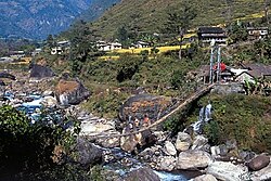
Khudi, Nepal 
Summary
Khudi, Nepal is a village development committee in Lamjung District in the Gandaki Zone of northern-central Nepal. At the time of the 1991 Nepal census it had a population of 3212 people living in 664 individual households.[1]
Khudi, Nepal
खुदि | |
|---|---|
 | |
 Khudi, Nepal Location in Nepal  Khudi, Nepal Khudi, Nepal (Nepal) | |
| Coordinates: 28°24′N 84°19′E / 28.40°N 84.31°E | |
| Country | |
| Zone | Gandaki Zone |
| District | Lamjung District |
| Population (1991) | |
| • Total | 3,212 |
| Time zone | UTC+5:45 (Nepal Time) |
| Postal Code | 33607 |
| Area code | 066 |
Climate edit
| Climate data for Khudi (Khudi Bazar) (elevation 823 m (2,700 ft), 1976–2005 normals) | |||||||||||||
|---|---|---|---|---|---|---|---|---|---|---|---|---|---|
| Month | Jan | Feb | Mar | Apr | May | Jun | Jul | Aug | Sep | Oct | Nov | Dec | Year |
| Mean daily maximum °C (°F) | 19.5 (67.1) |
21.7 (71.1) |
26.2 (79.2) |
29.7 (85.5) |
30.3 (86.5) |
30.6 (87.1) |
29.8 (85.6) |
30.0 (86.0) |
29.2 (84.6) |
27.4 (81.3) |
24.6 (76.3) |
20.7 (69.3) |
26.6 (80.0) |
| Mean daily minimum °C (°F) | 6.6 (43.9) |
8.7 (47.7) |
12.5 (54.5) |
15.8 (60.4) |
18.1 (64.6) |
20.3 (68.5) |
21.0 (69.8) |
21.0 (69.8) |
19.5 (67.1) |
15.2 (59.4) |
11.2 (52.2) |
7.5 (45.5) |
14.8 (58.6) |
| Average precipitation mm (inches) | 28.4 (1.12) |
46.7 (1.84) |
79.7 (3.14) |
103.7 (4.08) |
232.3 (9.15) |
538.7 (21.21) |
867.6 (34.16) |
838.4 (33.01) |
490.5 (19.31) |
94.6 (3.72) |
18.5 (0.73) |
23.2 (0.91) |
3,367.1 (132.56) |
| Source: Agricultural Extension in South Asia[2] | |||||||||||||
References edit
- ^ "Nepal Census 2001", Nepal's Village Development Committees, Digital Himalaya, archived from the original on 12 October 2008, retrieved 15 November 2009.
- ^ "TEMPORAL AND SPATIAL VARIABILITY OF CLIMATE CHANGE OVER NEPAL (1976-2005)" (PDF). Agricultural Extension in South Asia. Archived from the original (PDF) on 13 October 2023. Retrieved 14 October 2023.
External links edit
- UN map of the municipalities of Lamjung District