


Summary
Kianida Reef (Bulgarian: риф Кианида, romanized: rif Kianida, IPA: [ˈrif kiɐˈnidɐ]) is the 350 m long in east-west direction and 140 m wide, narrowing to the east rocky reef lying in Osogovo Bay, off the southeast extremity of Rugged Island in the South Shetland Islands. Its surface area is 4 ha.[1] The area was visited by early 19th century sealers.[2]
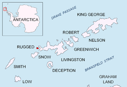 Location of Rugged Island in the South Shetland Islands | |
 Kianida Reef Location of Kianida Reef  Kianida Reef Kianida Reef (South Shetland Islands) | |
| Geography | |
|---|---|
| Location | Antarctica |
| Coordinates | 62°38′32″S 61°12′33″W / 62.64222°S 61.20917°W |
| Archipelago | South Shetland Islands |
| Area | 4 ha (9.9 acres) |
| Length | 350 m (1150 ft) |
| Width | 140 m (460 ft) |
| Administration | |
| Administered under the Antarctic Treaty System | |
| Demographics | |
| Population | uninhabited |

The feature is named after the phantom island of Kianida or Cianeis off the Black Sea coast of Thrace, featured on a 1467 map by Nicolaus Germanus based on Claudius Ptolemy's Geography.[1]
Location edit
Kianida Reef is located at 62°38′32″S 61°12′33″W / 62.64222°S 61.20917°W, which is 440 m southwest of Radev Point, 1.65 km west-southwest of Astor Island and 3.5 km north-northwest of Devils Point on Livingston Island. Detailed Spanish mapping in 1992, and Bulgarian mapping in 2009 and 2017.
Maps edit
- Península Byers, Isla Livingston. Mapa topográfico a escala 1:25000. Madrid: Servicio Geográfico del Ejército, 1992
- L. Ivanov. Antarctica: Livingston Island and Greenwich, Robert, Snow and Smith Islands. Scale 1:120000 topographic map. Troyan: Manfred Wörner Foundation, 2010. ISBN 978-954-92032-9-5 (First edition 2009. ISBN 978-954-92032-6-4)
- L. Ivanov. Antarctica: Livingston Island and Smith Island. Scale 1:100000 topographic map. Manfred Wörner Foundation, 2017. ISBN 978-619-90008-3-0
- Antarctic Digital Database (ADD). Scale 1:250000 topographic map of Antarctica. Scientific Committee on Antarctic Research (SCAR). Since 1993, regularly upgraded and updated
See also edit
Notes edit
References edit
- Kianida Reef. SCAR Composite Gazetteer of Antarctica
- Bulgarian Antarctic Gazetteer. Antarctic Place-names Commission. (details in Bulgarian, basic data in English)
External links edit
- Kianida Reef. Adjusted Copernix satellite image
This article includes information from the Antarctic Place-names Commission of Bulgaria which is used with permission.