
KNOWPIA
WELCOME TO KNOWPIA

Kiischpelt 
Summary
Kiischpelt is a commune in northern Luxembourg, in the canton of Wiltz. The commune's administrative centre is Wilwerwiltz.
Kiischpelt
Kiischpelt | |
|---|---|
 Wilwerwiltz | |
 Coat of arms | |
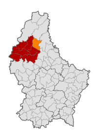 Map of Luxembourg with Kiischpelt highlighted in orange, and the canton in dark red | |
| Coordinates: 49°59′31″N 6°00′22″E / 49.9919°N 6.0061°E | |
| Country | |
| Canton | Wiltz |
| Area | |
| • Total | 33.58 km2 (12.97 sq mi) |
| • Rank | 20th of 100 |
| Highest elevation | 498 m (1,634 ft) |
| • Rank | 19th of 100 |
| Lowest elevation | 241 m (791 ft) |
| • Rank | 47th of 100 |
| Population (2023) | |
| • Total | 1,260 |
| • Rank | 97th of 100 |
| • Density | 38/km2 (97/sq mi) |
| • Rank | 102nd of 100 |
| Time zone | UTC+1 (CET) |
| • Summer (DST) | UTC+2 (CEST) |
| LAU 2 | LU0000805 |
| Website | kiischpelt.lu |
Kiischpelt was formed on 1 January 2006 from the former communes of Kautenbach and Wilwerwiltz, both in Wiltz canton. The law creating Kiischpelt was passed on 14 July 2005.[1]
It is the least densely populated commune in Luxembourg.
Populated places edit
The commune consists of the following villages:
|
|
Population edit
Footnotes edit
External links edit
 Media related to Kiischpelt at Wikimedia Commons