


Summary
Killcare Heights is a south-eastern suburb and village located on the Bouddi Peninsula of the Central Coast region of New South Wales, Australia. It is part of the Central Coast Council local government area.
| Killcare Heights Central Coast, New South Wales | |||||||||||||||
|---|---|---|---|---|---|---|---|---|---|---|---|---|---|---|---|
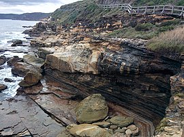 The Coast Walk in Bouddi National Park | |||||||||||||||
 | |||||||||||||||
| Population | 745 (2016 census)[1] | ||||||||||||||
| • Density | 830/km2 (2,140/sq mi) | ||||||||||||||
| Postcode(s) | 2257 | ||||||||||||||
| Elevation | 130 m (427 ft) | ||||||||||||||
| Area | 0.9 km2 (0.3 sq mi) | ||||||||||||||
| Location | |||||||||||||||
| LGA(s) | Central Coast Council | ||||||||||||||
| Parish | Kincumber | ||||||||||||||
| State electorate(s) | Terrigal | ||||||||||||||
| Federal division(s) | Robertson | ||||||||||||||
| |||||||||||||||
Demographics edit
| Country of Birth (2016)[2][3] | ||
| Birthplace[N 1] | Population | Percentage of Population |
|---|---|---|
| Australia | 594 | 79.7% |
| England | 58 | 7.8% |
| New Zealand | 13 | 1.7% |
| Germany | 11 | 1.5% |
95.3% of the population only speak English at home, with the most common languages spoken other than English being Mandarin, German and French. The median age of Killcare Heights is 47, significantly above the median age of NSW and Australia, which is 38.
41.4% of the population described themselves as without a religion; 21.1% described themselves as Catholic, and 17.1% as Anglican. Other residents have described themselves as members of the Uniting Church in Australia, Presbyterian church or Pentecostal church.
See also edit
Notes edit
References edit
- ^ Australian Bureau of Statistics (27 June 2017). "Killcare Heights (State Suburb)". 2016 Census QuickStats. Retrieved 10 November 2019.
- ^ "2016 Census Community Profiles: Greater Sydney".
- ^ "2016 Census QuickStats: Killcare Heights".
33°31′55″S 151°22′05″E / 33.532°S 151.368°E