
KNOWPIA
WELCOME TO KNOWPIA

Kir (river) 
Summary
The Kir (Albanian: Kir or Kiri) is a river in northern Albania that first flows south-southwest and then southwest out of the North Albanian Alps and enters a distributary of the Drin just below Shkodër.[2]
| Kir Lumi i Kirit[1] | |
|---|---|
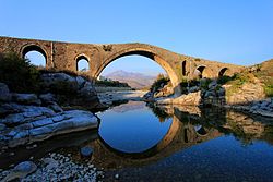 Kir river stream flowing under the Mesi Bridge | |
| Location | |
| Country | Albania |
| Physical characteristics | |
| Source | |
| • location | Albanian Alps |
| Mouth | |
• location | Great Drin |
• coordinates | 42°02′35″N 19°29′56″E / 42.04306°N 19.49889°E |
• elevation | 6 m (20 ft) |
| Basin features | |
| Progression | Great Drin→ Bojana→ Adriatic Sea |
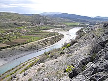
In the upper reaches the river cuts the "Canyon of the Kir" with dramatic cliffs.The Albanian tribe or fis of Kiri inhabited this area. Just outside Shkodër, in Mes, the old stone Mes Bridge crosses the Kir.
Notes edit
- ^ Lumi i Kirit (Approved) at GEOnet Names Server, United States National Geospatial-Intelligence Agency, Kiri (Variant) at GEOnet Names Server, United States National Geospatial-Intelligence Agency
- ^ "Kiri", Topographic map 1:250,000, Titograd, NK-34-04, series 1501, United States Defense Intelligence Agency
External links edit
- "Photo of Kirit River Valley". Panoramio. Archived from the original on 2018-12-15. Retrieved 2017-10-31. Static image Archived 2016-10-14 at the Wayback Machine
- "Photo of The Mes Bridge - Shkoderpublisher=Panoramio". Archived from the original on 2018-12-15. Retrieved 2017-10-31. Static image Archived 2016-10-13 at the Wayback Machine