
KNOWPIA
WELCOME TO KNOWPIA

Kletnyansky District 
Summary
Kletnyansky District (Russian: Клетня́нский райо́н) is an administrative[1] and municipal[7] district (raion), one of the twenty-seven in Bryansk Oblast, Russia. It is located in the northwest of the oblast. The area of the district is 1,583 square kilometers (611 sq mi).[2] Its administrative center is the urban locality (a work settlement) of Kletnya.[1] Population: 17,032 (2021 Census);[9] 20,166 (2010 Census);[3] 22,501 (2002 Census);[10] 23,885 (1989 Census).[11] The population of Kletnya accounts for 70.1% of the district's total population.[9]
Kletnyansky District
Клетнянский район | |
|---|---|
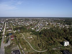 View of Kletnya | |
 Location of Kletnyansky District in Bryansk Oblast | |
| Coordinates: 53°23′23″N 33°13′11″E / 53.38972°N 33.21972°E | |
| Country | Russia |
| Federal subject | Bryansk Oblast[1] |
| Established | 1929 |
| Administrative center | Kletnya[1] |
| Area | |
| • Total | 1,583 km2 (611 sq mi) |
| Population | |
| • Total | 20,166 |
| • Estimate (2018)[4] | 18,314 (−9.2%) |
| • Density | 13/km2 (33/sq mi) |
| • Urban | 66.0% |
| • Rural | 34.0% |
| Administrative structure | |
| • Administrative divisions | 1 Settlement administrative okrugs, 5 Rural administrative okrugs |
| • Inhabited localities[5] | 1 Urban-type settlements[6], 92 rural localities |
| Municipal structure | |
| • Municipally incorporated as | Kletnyansky Municipal District[7] |
| • Municipal divisions[7] | 1 urban settlements, 5 rural settlements |
| Time zone | UTC+3 (MSK |
| OKTMO ID | 15626000 |
| Website | http://adm-kletnya.ru/ |
References edit
Notes edit
- ^ a b c d Law #13-Z
- ^ a b "Kletnyansky District, Indicators Characterising Condition of the Economy and Social Municipality" (in Russian). Federal State Statistics Service. Retrieved June 26, 2016.
- ^ a b Russian Federal State Statistics Service (2011). Всероссийская перепись населения 2010 года. Том 1 [2010 All-Russian Population Census, vol. 1]. Всероссийская перепись населения 2010 года [2010 All-Russia Population Census] (in Russian). Federal State Statistics Service.
- ^ "26. Численность постоянного населения Российской Федерации по муниципальным образованиям на 1 января 2018 года". Federal State Statistics Service. Retrieved January 23, 2019.
- ^ Law #69-Z stipulates that the borders of the administrative divisions match those of the corresponding municipal divisions. Law #3-Z contains the lists of the inhabited localities for each municipal division.
- ^ The count of urban-type settlements may include the work settlements, the resort settlements, the suburban (dacha) settlements, as well as urban-type settlements proper.
- ^ a b c Law #3-Z
- ^ "Об исчислении времени". Официальный интернет-портал правовой информации (in Russian). June 3, 2011. Retrieved January 19, 2019.
- ^ a b Russian Federal State Statistics Service. Всероссийская перепись населения 2020 года. Том 1 [2020 All-Russian Population Census, vol. 1] (XLS) (in Russian). Federal State Statistics Service.
- ^ Russian Federal State Statistics Service (May 21, 2004). Численность населения России, субъектов Российской Федерации в составе федеральных округов, районов, городских поселений, сельских населённых пунктов – районных центров и сельских населённых пунктов с населением 3 тысячи и более человек [Population of Russia, Its Federal Districts, Federal Subjects, Districts, Urban Localities, Rural Localities—Administrative Centers, and Rural Localities with Population of Over 3,000] (XLS). Всероссийская перепись населения 2002 года [All-Russia Population Census of 2002] (in Russian).
- ^ Всесоюзная перепись населения 1989 г. Численность наличного населения союзных и автономных республик, автономных областей и округов, краёв, областей, районов, городских поселений и сёл-райцентров [All Union Population Census of 1989: Present Population of Union and Autonomous Republics, Autonomous Oblasts and Okrugs, Krais, Oblasts, Districts, Urban Settlements, and Villages Serving as District Administrative Centers]. Всесоюзная перепись населения 1989 года [All-Union Population Census of 1989] (in Russian). Институт демографии Национального исследовательского университета: Высшая школа экономики [Institute of Demography at the National Research University: Higher School of Economics]. 1989 – via Demoscope Weekly.
Sources edit
- Брянская областная Дума. Закон №13-З от 5 июня 1997 г. «Об административно-территориальном устройстве Брянской области», в ред. Закона №4-З от 5 февраля 2014 г. «О внесении изменений в отдельные законодательные акты Брянской области». Опубликован: "Брянский рабочий", №119, 24 июня 1997 г. (Bryansk Oblast Duma. Law #13-Z of June 5, 1997 On the Administrative-Territorial Structure of Bryansk Oblast, as amended by the Law #4-Z of February 5, 2014 On Amending Various Legislative Acts of Bryansk Oblast. ).
- Брянская областная Дума. Закон №69-З от 2 ноября 2012 г. «Об образовании городских административных округов, поселковых административных округов, сельских административных округов, установлении границ, наименований и административных центров административных округов в Брянской области». Вступил в силу 1 января 2013 г. Опубликован: Информационный бюллетень "Официальная Брянщина", №16, 6 ноября 2012 г.. (Bryansk Oblast Duma. Law #69-Z of November 2, 2002 On the Establishment of Urban Administrative Okrugs, Settlement Administrative Okrugs, Rural Administrative Okrugs, on Establishing Borders, Names, and Administrative Centers of the Administrative Okrugs of Bryansk Oblast. Effective as of January 1, 2013.).
- Брянская областная Дума. Закон №3-З от 9 марта 2005 г. «О наделении муниципальных образований статусом статусом городского округа, муниципального района, городского поселения, сельского поселения и установлении границ муниципальных образований в Брянской области», в ред. Закона №75-З от 28 сентября 2015 г. «Об изменении статуса населённого пункта посёлок Красный Ятвиж Клетнянского района Брянской области». Вступил в силу через 10 дней после официального опубликования. Опубликован: "Брянская неделя", №13, 8 апреля 2005 г. (Bryansk Oblast Duma. Law #3-Z of March 9, 2005 On Granting the Municipal Formations the Status of Urban Okrug, Municipal District, Urban Settlement, Rural Settlement and on Establishing the Borders of the Municipal Formations of Bryansk Oblast, as amended by the Law #75-Z of September 28, 2015 On Changing the Status of the Inhabited Locality the Settlement of Krasny Yatvizh in Kletnyansky District of Bryansk Oblast. Effective as of the day which is 10 days after the official publication.).