


Summary
The Kobe Route (神戸線, Kobe-sen), signed as Route 3, is one of the routes of the Hanshin Expressway system serving the Keihanshin area in Kansai, Japan. It is an intercity route that travels in an east to west direction from Osaka to Kobe, with a total length of 39.4 kilometers (24.5 mi).
 阪神高速3号神戸線 | |
|---|---|
 The Kobe Route highlighted in red | |
| Route information | |
| Maintained by Hanshin Expressway Company, Limited | |
| Length | 39.4 km (24.5 mi) |
| Existed | 1966–present |
| Major junctions | |
| East end | Awaza Junction in Nishi-ku, Osaka |
| West end | |
| Location | |
| Country | Japan |
| Highway system | |
Route description edit
The Kobe Route begins at Awaza Junction in Nishi-ku, Osaka, where it meets the Ōsakakō Route. From there it travels west from central Osaka. It meets the planned outer loop expressway of the city, the partially completed Yodogawa-Sagan Route, on the southern bank of the Yodo River.[1] After this, the expressway crosses into the city of Amagasaki in eastern Hyōgo Prefecture. Upon entering Amagasaki, the expressway meets National Route 43, which then travels directly alongside the expressway all the way to Kobe.[2]
Along the way to Kobe the expressway has a junction with the Meishin Expressway, the western terminus of that expressway, though direct access to the Meishin Expressway is limited with access being completed via National Route 43.[3] In Nada-ku, Kobe, National Route 43 diverges from the Kobe Route and ends at an intersection with National Route 2. National Route 2 then takes its place as the parallel road for the Kobe Route through central Kobe.[3]
In central Kobe, the expressway closely follows the coastline of the Port of Kobe. Along this stretch of the route, a junction connects the expressway to the Shin-Kobe Tunnel.[3] Continuing west, the expressway leaves the coastline and central Kobe. It then curves north in Suma-ku, Kobe, leaving National Route 2. The expressway meets its western terminus in the ward, but continues west as the Daini-Shinmei Road.[4]
History edit
The first section of the Kobe Route was opened in 1966. The elevated section of the expressway in central Kobe was built in 1969 during the preparation for the Expo '70 world's fair held in nearby Suita.[5]
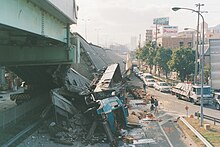
When 18 spans of this section collapsed in 1995 during the Great Hanshin earthquake, the stricken expressway became a focal point of the disaster for the media.[6][7] The structure could not resist the forces of the unprecedented earthquake due to various design inadequacies, including too shallow a foundation for the support pillars and a lack of sufficient either external or internal transverse reinforcement for the pillars. The collapse of the structure did not result in any casualties. The elevated expressway was rebuilt by the end of 1996 and the surviving pillars were retrofitted with steel sheathing to prevent the same type of failure from recurring.[8][9]
On 18 December 2010, the Kobe Route was linked to the Kobe-Yamate Route after Minatogawa Junction was opened to traffic.[10] On 31 October 2016, Amagasaki-Shūya Toll Gate was removed,[11] it was replaced with a parking area that opened on 19 March 2019.[12]
List of interchanges edit
| Prefecture | Location | km[2] | mi | Exit | Name | Destinations | Notes |
|---|---|---|---|---|---|---|---|
| Osaka | Osaka | 0.0 | 0.0 | – | Awaza | Eastern terminus | |
| 0.3 | 0.19 | 3-01 | Nishinagahori | Osaka Prefecture Route 29 (Shin-Naniwasuji) | Eastbound exit, westbound entrance | ||
| 0.9 | 0.56 | 3-02 | Nakanoshima-nishi | Nakanoshima-dōri | Eastbound exit, westbound entrance | ||
| 3.1 | 1.9 | 3-03 | Ebie | Osaka-Shidōkujō-Umeda Route | Eastbound exit, westbound entrance | ||
| 3.2 | 2.0 | – | Ebie | Eastbound exit, westbound entrance | |||
| 4.2 | 2.6 | 3-04 | Himejima | Unnamed city streets | Eastbound entrance, westbound exit | ||
| 5.1 | 3.2 | 3-05 | Ōwada | Yodogawa-dōri | Eastbound exit, westbound entrance | ||
| Hyōgo | Amagasaki | 7.0 | 4.3 | 3-06 | Amagasaki-higashi | Unnamed city streets | Eastbound exit only |
| 8.3 | 5.2 | PA | Amagasaki | Parking area for westbound traffic; formerly a toll gate | |||
| 10.7 | 6.6 | 3-07 | Amagasaki-nishi | Unnamed city streets | Eastbound exit, westbound entrance | ||
| Nishinomiya | 11.9 | 7.4 | 3-08 | Mukogawa | Eastbound entrance, westbound exit; westbound traffic for the Meishin Expressway needs to exit here. | ||
| 14.5 | 9.0 | 3-09 | Nishinomiya | Eastbound exit, westbound entrance; western terminus of E1 | |||
| 16.8 | 10.4 | 3-10 | Nishinomiya | Eastbound exit, westbound entrance | |||
| Ashiya | 17.4 | 10.8 | 3-11 | Ashiya | Eastbound entrance, westbound exit | ||
| 17.8 | 11.1 | Ashiya Toll Booth | Westbound traffic only | ||||
| Kobe | 21.4 | 13.3 | 3-12 | Fukae | Eastbound exit, westbound entrance | ||
| 22.7 | 14.1 | 3-13 | Uozaki | Eastbound entrance, westbound exit | |||
| 27.3 | 17.0 | 3-14 / 3-15 | Maya | ||||
| 29.6 | 18.4 | 3-16 | Ikutagawa | Unnamed city streets | ETC-only entrance from Shin-Kobe Tunnel and National Route 2, eastbound exit to city streets | ||
| 30.8 | 19.1 | 3-17 / 3-18 / PA | Kyōbashi | ||||
| 34.2 | 21.3 | 3-19 / 3-20 | Yanagihara | ||||
| 36.1 | 22.4 | 3-21 / 3-22 | Minatogawa | Unnamed city streets | No access to Kobe-Yamate Route for eastbound traffic | ||
| 38.1 | 23.7 | 3-23 | Wakamiya | Eastbound entrance, westbound exit | |||
| 39.4 | 24.5 | 3-24 | Tsukimiyama | Hyōgo Prefecture Route 21 (Kobe-Akashi Route) – Suma | Eastbound entrance, westbound exit | ||
| 39.4 | 24.5 | Western terminus of Kobe Route, expressway continues west as the Daini-Shimmei Road | |||||
1.000 mi = 1.609 km; 1.000 km = 0.621 mi
| |||||||
See also edit
 Japan portal
 Roads portal
References edit
- ^ "Osaka Grand Design" (PDF). Metropolis Development Division, Department of Housing and City Development Osaka Prefectural Government. Retrieved 29 March 2020.
- ^ a b Google (29 March 2020). "Kobe Route" (Map). Google Maps. Google. Retrieved 29 March 2020.
- ^ a b c "Expressway Map". Hanshin Expressway Company. Retrieved 16 April 2020.
- ^ "Expressway Map". Archived from the original on 23 September 2017. Retrieved 26 March 2020.
- ^ "Since 1950s-1970". Hanshin Expressway. Retrieved 27 March 2020.
- ^ Nicholas D. Kristof (17 January 1995). "QUAKE IN JAPAN: THE OVERVIEW; AT LEAST 597 ARE KILLED IN JAPANESE QUAKE; KOBE DEVASTATED AS 2,000 BUILDINGS BUCKLE". The New York Times. Retrieved 27 March 2020.
- ^ "Earthquake devastates Kobe". BBC News. 17 January 1995. Retrieved 27 March 2020.
- ^ Hamid Ghasemi; Hisanori Otsuka; James D. Cooper; Hiroyuki Nakajima (1996). "Aftermath of The Kobe Earthquake". Public Roads. Retrieved 27 March 2020.
- ^ Gazetas, George; Anastasopoulos, Ioannis; Gerolymos, Nikos; Mylonakis, George; Syngros, Costis (2006). "The Collapse of the Hanshin Expressway (Fukae) Bridge, Kobe 1995: Soil-Foundation-Structure Interaction, Reconstruction, Seismic Isolation". Entwicklungen in der Bodenmechanik, Bodendynamik und Geotechnik. Springer Science+Business Media. pp. 93–120. doi:10.1007/3-540-27438-3_7. ISBN 3-540-27425-1. Retrieved 27 March 2020.
- ^ "History(-2000)". Hanshin Expressway. Retrieved 27 March 2020.
- ^ "阪神高速3号神戸線2016年度 尼崎西-阿波座フレッシュアップ工事リーフレット" [Hanshin Expressway Route 3 Kobe Route 2016 Amagasaki Nishi-Awaza Fresh Up Construction Leaflet] (PDF). Hanshin Expressway (in Japanese). 2016. Retrieved 27 March 2020.
- ^ "3月19日(火)「尼崎PA」「南芦屋浜PA」を新たに同時オープンします" [Amagasaki and Minami-Ashiyahama parking areas to open on 19 March] (PDF). Hanshin Expressway (in Japanese). 21 February 2019. Retrieved 27 March 2020.
External links edit
 Media related to Hanshin Expressway Route 3 Kobe Route at Wikimedia Commons