


Summary
Kohat District (Pashto: کوهاټ ولسوالۍ, Urdu: ضلع کوہاٹ) is a district in the Kohat Division of the Khyber Pakhtunkhwa province of Pakistan. Kohat city is its district capital.
Kohat District
ضلع کوہاٹ کوهاټ ولسوالۍ | |
|---|---|
  | |
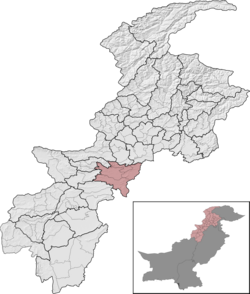 Kohat District (red) in Khyber Pakhtunkhwa | |
| Country | Pakistan |
| Province | Khyber Pakhtunkhwa |
| Division | Kohat |
| Headquarters | Kohat |
| Government | |
| • Type | District Administration |
| • Deputy Commissioner | Roshan Mehsud |
| • District Police Officer | N/A |
| • District Health Officer | N/A |
| Area | |
| • Total | 2,991 km2 (1,155 sq mi) |
| Population (2017)[1] | |
| • Total | 993,874 |
| • Density | 330/km2 (860/sq mi) |
| Time zone | UTC+5 (PST) |
| Number of Tehsils | 4 |
| Website | kohat |
History edit
Mughal era edit
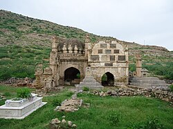
From the early sixteenth century, the history of Kohat revolves around three major tribes namely Bangash, Banoori, and Afridi. These people seemingly established their settlements within the district during the 14th and 15th centuries. From 16th to 18th centuries, Kohat being the part of Mughal Empire was administered by the chiefs of the two aforementioned tribes.
Demography edit
| Year | Pop. | ±% p.a. |
|---|---|---|
| 1961 | 209,817 | — |
| 1972 | 308,507 | +3.57% |
| 1981 | 383,862 | +2.46% |
| 1998 | 651,100 | +3.16% |
| 2017 | 1,111,266 | +2.85% |
| Sources:[2] | ||
At the time of the 2017 census, the district had 132,985 households and a population of 1,111,266. Kohat had a sex ratio of 999 females per 1000 males and a literacy rate was 58.59% - 77.75% for males and 39.96% for females. 269,926 (24.29%) lived in urban areas. 28.66% of the population were under 10 years of age.[1][3]
At the time of the 2011 census, 83.85% of the population spoke Pashto, 12.87% Hindko, 1.24% Urdu and 1.19% Punjabi as their first language.
Religion edit
| Religion | Population (1941)[4]: 22 | Percentage (1941) | Population (2017) | Percentage (2017) |
|---|---|---|---|---|
| Islam |
266,224 | 91.99% | 1,106,709 | 99.59% |
| Hinduism |
17,527 | 6.06% | 1,004 | 0.09% |
| Sikhism |
4,349 | 1.5% | 71 | 0.01% |
| Christianity |
1,304 | 0.45% | 3,190 | 0.29% |
| Total Population | 289,404 | 100% | 1,111,266 | 100% |
Kohat is one of the few areas of Khyber Paktunkhwa which still contains a sizeable Hindu and Sikh communities.
Administration edit
Kohat district is divided into four Tehsils:
- Kohat (Urdu: تحصیل کوہاٹ)(Pashto: کوهاټ تحصیل)[5]
- Lachi (Urdu: تحصیل لاچی)(Pashto: لاچي تحصیل)
- Gumbat (Urdu: تحصیل گمبٹ)(Pashto: ګمبټ تحصیل)
- Dara Adam Khel Tehsil (Urdu: تحصیل درہ آدم خیل)(Pashto: دره ادم خېل تحصیل)
- formerly Frontier Region Kohat (Urdu: سرحدی علاقہ کوہاٹ)(Pashto: کوهاټ سرحدي سیمه)
Provincial Assembly edit
| Member of Provincial Assembly | Party Affiliation | Constituency | Year |
|---|---|---|---|
| Amjad Khan Afridi | Independent | PK-80 Kohat-I | 2018 |
| Shah Dad Khan | Muttahida Majlis-e-Amal | PK-81 Kohat-II | 2018 |
| Zia Ullah Khan Bangash | Pakistan Tehreek-e-Insaf | PK-82 Kohat-III | 2018 |
References edit
- ^ a b "Kohat District population (Census - 2017)". Citypopulation.de website. Archived from the original on 29 April 2020. Retrieved 26 October 2023.
- ^ "Population by administrative units 1951-1998" (PDF). Pakistan Bureau of Statistics.
- ^ "Kohat District population - Detailed Information" (PDF). Pakistan Bureau of Statistics (PBS), Government of Pakistan website. Archived from the original (PDF) on 12 October 2021. Retrieved 26 October 2023.
- ^ "CENSUS OF INDIA, 1941 VOLUME X NORTH-WEST FRONTIER PROVINCE". Retrieved 14 October 2021.
- ^ "Tehsils & Unions in the District of Kohat". National Reconstruction Bureau (NRB), Government of Pakistan website. Archived from the original on 26 March 2012. Retrieved 26 October 2023.
Bibliography edit
- 1981 District Census report of Kohat. District Census Report. Vol. 27. Islamabad: Population Census Organization, Statistics Division, Government of Pakistan. 1983.
- 1998 District Census report of Kohat. Census publication. Vol. 42. Islamabad: Population Census Organization, Statistics Division, Government of Pakistan. 1999.
- Shackle, Christopher (1980). "Hindko in Kohat and Peshawar". Bulletin of the School of Oriental and African Studies. 43 (3): 482–510. doi:10.1017/S0041977X00137401. ISSN 0041-977X. S2CID 129436200.
33°20′N 71°10′E / 33.333°N 71.167°E