


Summary
Komsomolets Island (Russian: остров Комсомолец) is the northernmost island of the Severnaya Zemlya group in the Russian Arctic, and the third largest island in the group. It is the 82nd largest island on earth. About 65% of the island is covered with glaciers, including Russia's largest, the Academy of Sciences Glacier.
Native name: остров Комсомолец | |
|---|---|
 | |
 Komsomolets  Komsomolets | |
| Geography | |
| Location | Krasnoyarsk Krai, Russia |
| Coordinates | 80°29′03″N 94°59′47″E / 80.48417°N 94.99639°E |
| Archipelago | Severnaya Zemlya, Russia |
| Area | 9,006 km2 (3,477 sq mi) |
| Highest elevation | 935 m (3068 ft) |
| Administration | |
Russia | |

Geography edit
Komsomolets Island is separated from October Revolution Island in the south by the Red Army Strait and from Pioneer Island in the southwest by the Yuny Strait.[1] The northernmost point of the island is the Arctic Cape, the launching point for many Arctic expeditions.
Practically the whole of the central and southern part of the island is covered by the massive Academy of Sciences Glacier, between Krenkel Bay in the east and Zhuravlev Bay in the west.[2] The northern part is largely unglaciated. The area of this island has been estimated at 9,006 km2. It rises to a height of 780 m. Komsomolets Island is home to the largest ice cap in Russia, the Academy of Sciences Ice Cap.[3]
Geology edit
The soil of the island is mostly composed of loose loam and sands, a tundra desert scattered with mosses and lichens.[4]
History edit
The island was discovered by Boris Vilkitsky in 1913, but it was not proven to be an island until 1931, when Georgy Ushakov and Nikolay Urvantsev charted the archipelago during their 1930–32 expedition.[5] They also named it. In keeping with their tradition of naming the islands after events and movements of the Russian Revolution, this island was named in honour of the members of the Komsomol, the "Communist Union of Youth."
Photo gallery edit
-
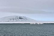
 Krenkel Bay, eastern coast of Komsomolets Island (80°40’N, 97°30‘O)
 -
 Krenkel Bay
 -
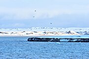
 Abandoned Russian polar station Izluchina (Northeast coast of Komsomolets Island; 81°N, 96°33’E).
 -
 Komsomolets Island:
Empty oil drums at Arctic Cape (Komsomolets Island; 81°15‘N, 95°39‘E). -
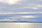 Zhuravlev Bay, located in the west coast of Komsomolets Island (80°44’N, 93°19‘E).
 -
 Zhuravlev Bay
 -
 Zhuravlev Bay
 -
 Zhuravlev Bay


References edit
- ^ "Proliv Yunyy". Mapcarta. Retrieved 26 November 2016.
- ^ "Lednik Akademii Nauk". Mapcarta. Retrieved 24 December 2016.
- ^ "Severnaya Zemlya 1999-2000". Ecoshelf. Archived from the original on February 5, 2012. Retrieved March 14, 2012.
{{cite web}}: External link in|publisher= - ^ https://web.archive.org/web/20101223015139/http://www.oceandots.com/arctic/severnaya-zemlya Russian Arctic - Severnaya Zemlya[dead link]
- ^ Barr, William (1975). "Severnaya Zemlya: the last major discovery". Geographical Journal. 141 (1): 59–71. doi:10.2307/1796946.
External links edit
 Media related to Komsomolets Island at Wikimedia Commons
- Photos of the Academy of Science Ice Cap: [1]
- Facts and dramatic satellite photos of the islands of the Severnaya Zemlya group: [2]
80°29′03″N 94°59′47″E / 80.48417°N 94.99639°E