


Summary
Krasnohvardiiske Raion (Russian: Красногвардейский район), known by Ukrainian authorities[nb 1] as Kurman Raion (Ukrainian: Курманський район, Crimean Tatar: Къурман районы, romanized: Qurman rayonı) is one of the 25 regions of the Autonomous Republic of Crimea, a territory recognised by a majority of countries as part of Ukraine and annexed by Russia. The administrative centre of the raion is the urban-type settlement of Krasnohvardiiske. Krasnohvardiiske Raion is located in the central part of Crimea. Population: 83,135 (2014 Census).[2]
Krasnohvardiiske Raion
Qurman rayonı | |
|---|---|
 Village Hryhoriivka, Krasnohvardiiske District | |
 Flag  Coat of arms | |
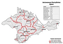
 Raion location within Crimea | |
| Country | Territory of Ukraine, occupied by Russia[1] |
| Republic | Crimea |
| Capital | Krasnohvardiiske |
| Subdivisions | List
|
| Area | |
| • Total | 1,766 km2 (682 sq mi) |
| Population (2014) | |
| • Total | 83,135 |
| • Density | 47/km2 (120/sq mi) |
| Time zone | UTC+2 |
| • Summer (DST) | +3 |
| Dialing code | +380-6556 |
Settlements edit
The raion contains two urban-type settlements: Krasnohvardiiske and Oktiabrske, and eighty-two villages, including:
History edit
Russian annexation of Crimea edit
In 2014, Russia unilaterally and illegally annexed Crimea from Ukraine. This has not been recognized by the international community, but Russia has continued to occupy the peninsula.
2020 Ukrainian administrative reform edit
In July 2020, Ukraine conducted an administrative reform throughout its de jure territory. This included Crimea, which was still occupied by Russia. Crimea was reorganized from 14 raions and 11 municipalities into 10 raions, with municipalities abolished altogether. The territory of Kurman Raion was expanded to also include the territories of Pervomaiske Raion, but has not yet been implemented due to the ongoing Russian occupation.[3]
Notes edit
- ^ The renaming has been effected by Ukraine's decommunization laws, but as Crimea is outside of Ukrainian control, this decision has had little practical effect.
References edit
- ^ This place is located on the Crimean peninsula, which is internationally recognized as part of Ukraine, but since 2014 under Russian occupation. According to the administrative-territorial division of Ukraine, there are the Ukrainian divisions (the Autonomous Republic of Crimea and the city with special status of Sevastopol) located on the peninsula. Russia claims these as federal subjects of the Russian Federation (the Republic of Crimea and the federal city of Sevastopol).
- ^ Russian Federal State Statistics Service (2014). "Таблица 1.3. Численность населения Крымского федерального округа, городских округов, муниципальных районов, городских и сельских поселений" [Table 1.3. Population of Crimean Federal District, Its Urban Okrugs, Municipal Districts, Urban and Rural Settlements]. Федеральное статистическое наблюдение «Перепись населения в Крымском федеральном округе». ("Population Census in Crimean Federal District" Federal Statistical Examination) (in Russian). Federal State Statistics Service. Retrieved January 4, 2016.
- ^ "Про утворення та ліквідацію районів". Офіційний вебпортал парламенту України (in Ukrainian). Retrieved 2023-10-16.
45°29′41″N 34°17′41″E / 45.49472°N 34.29472°E