


Summary
Krasnoperekopsk Raion (Ukrainian: Красноперекопський район, Russian: Красноперекопский район, Crimean Tatar: Krasnoperekopsk rayonı) is one of the 25 districts of the Autonomous Republic of Crimea, a territory recognized by a majority of countries as part of Ukraine and incorporated by Russia as the Republic of Crimea. It is situated in the northern part of the republic. The administrative center of the raion is the town of Krasnoperekopsk. The latter is not a part of the raion (district) and incorporated separately as a town of regional significance. Population (without Krasnoperekopsk): 24,738 (2014 Census).[1]
Krasnoperekopsk Raion
Krasnoperekopsk rayonı | |
|---|---|
 Karkinit Bay, Krasnoperekopsky District | |
 Flag  Seal | |
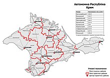
 Raion location within Crimea | |
| Country | |
| Republic | Crimea |
| Capital | Krasnoperekopsk |
| Subdivisions | List
|
| Area | |
| • Total | 1,231 km2 (475 sq mi) |
| Population (2014) | |
| • Total | 24,738 |
| • Density | 20/km2 (52/sq mi) |
| Time zone | UTC+3 (MSK) |
| Dialing code | +380-6565 |
On 12 May 2016, Ukrainian authorities[nb 1] renamed the district to Perekop Raion (Ukrainian: Перекопський район) as part of its decommunization efforts. The renaming will be in effect when Ukraine take back control of Crimea.[5]
Demographics edit
The Raion had a population of 31.843 according to the 2001 Ukrainian census. The largest ethnic group are Ukrainians, accounting for almost half of the population, followed by Russians, Crimean Tatars and Belarusians.[6] Rural areas are vastly Ukrainophone, while population centers are mostly Russian-speaking. Crimean Tatar is spoken by a significant minority in almost every settlement.[7]
| Native language | Inhabitants | Percentage |
|---|---|---|
| Russian | 16,958 | 53,3% |
| Ukrainian | 8,529 | 26.8% |
| Crimean Tatar | 4,944 | 15.5% |
| Belarusian | 113 | 0.4% |
| others | 1.018 | 3.2% |
| Total: | 31,843 | 100% |
2020 Ukrainian Administrative Reform edit
In July 2020, Ukraine conducted an administrative reform throughout its de jure territory. This included Crimea, which was at the time occupied by Russia, and is still ongoing as of October 2023. Crimea was reorganized from 14 raions and 11 municipalities into 10 raions, with municipalities abolished altogether. The territory of Perekop Raion was expanded to also include the territories of Armiansk Municipality, Yani Qapu Municipality, and Rozdolne Raion, but has not yet been implemented due to the ongoing Russian occupation.[8]
Notes edit
- ^ Since the 2014 Crimean crisis, the status of the Crimea and of the city of Sevastopol is under dispute between Russia and Ukraine; Ukraine and the majority of the international community considers the Crimea and Sevastopol an integral part of Ukraine, while Russia, on the other hand, considers the Crimea and Sevastopol an integral part of Russia, with Sevastopol functioning as a federal city within the Crimean Federal District.[2][3][4]
References edit
- ^ Russian Federal State Statistics Service (2014). "Таблица 1.3. Численность населения Крымского федерального округа, городских округов, муниципальных районов, городских и сельских поселений" [Table 1.3. Population of Crimean Federal District, Its Urban Okrugs, Municipal Districts, Urban and Rural Settlements]. Федеральное статистическое наблюдение «Перепись населения в Крымском федеральном округе». ("Population Census in Crimean Federal District" Federal Statistical Examination) (in Russian). Federal State Statistics Service. Retrieved January 4, 2016.
- ^ Gutterman, Steve. "Putin signs Crimea treaty, will not seize other Ukraine regions". Reuters.com. Retrieved 26 March 2014.
- ^ "Ukraine crisis timeline". BBC News.
- ^ UN General Assembly adopts resolution affirming Ukraine's territorial integrity Archived 2018-03-04 at the Wayback Machine, China Central Television (28 March 2014)
- ^ Верховна Рада України; Постанова від 12.05.2016 № 1352-VIII Про перейменування окремих населених пунктів та районів Автономної Республіки Крим та міста Севастополя (in Ukrainian)
- ^ https://web.archive.org/web/20140410223909/http://sf.ukrstat.gov.ua/
- ^ https://socialdata.org.ua/projects/mova-2001/
- ^ "Про утворення та ліквідацію районів". Офіційний вебпортал парламенту України (in Ukrainian). Retrieved 2023-10-16.
45°58′03″N 33°48′01″E / 45.96750°N 33.80028°E