


Summary
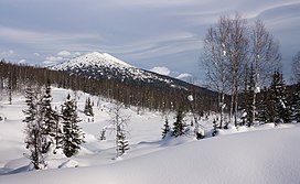
Kuznetsk Alatau (Russian: Кузнецкий Алатау) is a mountain range in southern Siberia, Russia. The range rises in the Altai-Sayan region of the South Siberian Mountains, northwest of Mongolia. The Siberian Railway skirts the northern limit of the range.[2]
| Kuznetsk Alatau | |
|---|---|
| Кузнецкий Алатау | |
 | |
| Highest point | |
| Peak | Staraya Krepost |
| Elevation | 2,217 m (7,274 ft) |
| Coordinates | 53°51′34″N 89°18′01″E / 53.85944°N 89.30028°E[1] |
| Dimensions | |
| Length | 300 km (190 mi) SW / NE |
| Width | 150 km (93 mi) |
| Geography | |
 Location in Khakassia 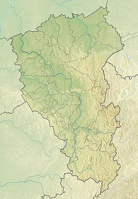 Kuznetsk Alatau (Kemerovo Oblast)  Kuznetsk Alatau (Russia) | |
| Country | Russia |
| Federal subject | Khakassia Kemerovo Oblast |
| Range coordinates | 53°45′N 89°15′E / 53.750°N 89.250°E |
| Parent range | Altai/Sayan South Siberian System |
| Geology | |
| Orogeny | Alpine orogeny |
| Age of rock | Proterozoic, Lower Paleozoic |
| Type of rock | Gabbro, diorite, granite and syenite intrusive rocks |


Geography edit
The Kuznetsk Alatau consists of several ridges of medium height stretching for about 300 kilometres (186 mi) between the Kuznetsk Depression and the Minusinsk Depression. The highest peak[citation needed] is 2,217 metres (7,274 ft) high Staraya Krepost, another important peak is 2,178 metres (7,146 ft) high Verkhny Zub. The Abakan Range is at the southern limit and to the north the range descends gradually to the West Siberian Plain. To the east lies the basin of the Yenisei. The mountains have generally a smooth outline with rather steep western slopes and gentler eastern ones.[3][2]
The range is composed mainly of metamorphic rocks rich in iron, manganese, nephelines, and gold.
Flora edit
The Siberian fir overwhelmingly predominates in the forest belt except for its upper part where, at the tree line (1300–1900 m), the siberian pine becomes dominant. The highlands are occupied mostly by vast large-stoned screes, and also by patches of subalpine meadows and, on some southern mountain massifs, of bushy, lichen and moss tundras. The basin of the Kondoma River in Gornaya Shoriya is remarkable for the Siberian lime-tree woods which are thought to be the relics of a pre-Pleistocene nemoral vegetation of Siberia. All over the upland, the forest openings are occupied by long forb forest meadows.[3]
See also edit
- Aeroflot Flight 593 crashed in into the Kuznetsk Alatau
- Kuznetsk Alatau Nature Reserve
- Geography of South-Central Siberia
 Siberia portal
References edit