


Summary
L'Hospitalet-du-Larzac (French pronunciation: [lɔspitalɛ dy laʁzak]; Occitan: L'Espitalet de Larzac) is a commune in the Aveyron department in southern France, part of the southern Massif central, incorporating part of the Larzac plateau.
L'Hospitalet-du-Larzac | |
|---|---|
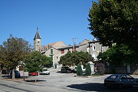 The church and surrounding buildings in L'Hospitalet-du-Larzac | |
 Coat of arms | |
Location of L'Hospitalet-du-Larzac .mw-parser-output .locmap .od{position:absolute}.mw-parser-output .locmap .id{position:absolute;line-height:0}.mw-parser-output .locmap .l0{font-size:0;position:absolute}.mw-parser-output .locmap .pv{line-height:110%;position:absolute;text-align:center}.mw-parser-output .locmap .pl{line-height:110%;position:absolute;top:-0.75em;text-align:right}.mw-parser-output .locmap .pr{line-height:110%;position:absolute;top:-0.75em;text-align:left}.mw-parser-output .locmap .pv>div{display:inline;padding:1px}.mw-parser-output .locmap .pl>div{display:inline;padding:1px;float:right}.mw-parser-output .locmap .pr>div{display:inline;padding:1px;float:left}html.skin-theme-clientpref-night .mw-parser-output .od,html.skin-theme-clientpref-night .mw-parser-output .od .pv>div,html.skin-theme-clientpref-night .mw-parser-output .od .pl>div,html.skin-theme-clientpref-night .mw-parser-output .od .pr>div{background:#000;color:#fff}html.skin-theme-clientpref-night .mw-parser-output .locmap{filter:grayscale(0.6)}@media(prefers-color-scheme:dark){html.skin-theme-clientpref-os .mw-parser-output .locmap{filter:grayscale(0.6)}html.skin-theme-clientpref-os .mw-parser-output .od,html.skin-theme-clientpref-os .mw-parser-output .od .pv>div,html.skin-theme-clientpref-os .mw-parser-output .od .pl>div,html.skin-theme-clientpref-os .mw-parser-output .od .pr>div{background:#000;color:#fff}}  L'Hospitalet-du-Larzac  L'Hospitalet-du-Larzac | |
| Coordinates: 43°58′27″N 3°11′49″E / 43.9742°N 3.1969°E | |
| Country | France |
| Region | Occitania |
| Department | Aveyron |
| Arrondissement | Millau |
| Canton | Causses-Rougiers |
| Government | |
| • Mayor (2020–2026) | Thierry Cartayrade[1] |
| Area 1 | 12.4 km2 (4.8 sq mi) |
| Population (2021)[2] | 326 |
| • Density | 26/km2 (68/sq mi) |
| Time zone | UTC+01:00 (CET) |
| • Summer (DST) | UTC+02:00 (CEST) |
| INSEE/Postal code | 12115 /12230 |
| Elevation | 699–861 m (2,293–2,825 ft) (avg. 730 m or 2,400 ft) |
| 1 French Land Register data, which excludes lakes, ponds, glaciers > 1 km2 (0.386 sq mi or 247 acres) and river estuaries. | |
The economy is agricultural, notably dairy produce (Roquefort cheese), but also beef and mutton production, and rural tourism.
L'Hospitalet-du-Larzac is the site of discovery of one of the longest and most important inscriptions in the Gaulish language, a lead curse tablet (found in 1983).
The commune is named for a historical hospital founded by viscount Millau Gilbert (or Guibert) in 1108. It was owned by Cassan Abbey from 1174 to 1789. The parish church was at Saint-Étienne-du-Larzac, now ruined, in what is now part of Sainte-Eulalie-de-Cernon commune. The hospital was fortified in the early 15th century, after which the parish center was transferred there. The current parish church dates to 1764, presumably built on top of an older structure.
In 1807, the parish was enlarged, incorporating d’Egalières, du Sambuc, Trinquier and du Rouquet. The modern commune was formed in 1834, with the dissolution of the predecessor commune of La Cavalerie.
| Year | Pop. | ±% |
|---|---|---|
| 1962 | 205 | — |
| 1968 | 218 | +6.3% |
| 1975 | 233 | +6.9% |
| 1982 | 247 | +6.0% |
| 1990 | 246 | −0.4% |
| 1999 | 249 | +1.2% |
| 2008 | 331 | +32.9% |
See also edit
References edit
- ^ "Répertoire national des élus: les maires". data.gouv.fr, Plateforme ouverte des données publiques françaises (in French). 9 August 2021.
- ^ "Populations légales 2021". The National Institute of Statistics and Economic Studies. 28 December 2023.