


Summary
La Clayette (French pronunciation: [la.klɛt][3]) is a commune in the east-central French department of Saône-et-Loire.
La Clayette | |
|---|---|
 The Château de La Clayette as seen from the Place des Fossés | |
 Coat of arms | |
Location of La Clayette .mw-parser-output .locmap .od{position:absolute}.mw-parser-output .locmap .id{position:absolute;line-height:0}.mw-parser-output .locmap .l0{font-size:0;position:absolute}.mw-parser-output .locmap .pv{line-height:110%;position:absolute;text-align:center}.mw-parser-output .locmap .pl{line-height:110%;position:absolute;top:-0.75em;text-align:right}.mw-parser-output .locmap .pr{line-height:110%;position:absolute;top:-0.75em;text-align:left}.mw-parser-output .locmap .pv>div{display:inline;padding:1px}.mw-parser-output .locmap .pl>div{display:inline;padding:1px;float:right}.mw-parser-output .locmap .pr>div{display:inline;padding:1px;float:left}html.skin-theme-clientpref-night .mw-parser-output .od,html.skin-theme-clientpref-night .mw-parser-output .od .pv>div,html.skin-theme-clientpref-night .mw-parser-output .od .pl>div,html.skin-theme-clientpref-night .mw-parser-output .od .pr>div{background:#000;color:#fff}html.skin-theme-clientpref-night .mw-parser-output .locmap{filter:grayscale(0.6)}@media(prefers-color-scheme:dark){html.skin-theme-clientpref-os .mw-parser-output .locmap{filter:grayscale(0.6)}html.skin-theme-clientpref-os .mw-parser-output .od,html.skin-theme-clientpref-os .mw-parser-output .od .pv>div,html.skin-theme-clientpref-os .mw-parser-output .od .pl>div,html.skin-theme-clientpref-os .mw-parser-output .od .pr>div{background:#000;color:#fff}}  La Clayette  La Clayette | |
| Coordinates: 46°17′26″N 4°18′20″E / 46.2906°N 4.3056°E | |
| Country | France |
| Region | Bourgogne-Franche-Comté |
| Department | Saône-et-Loire |
| Arrondissement | Charolles |
| Canton | Chauffailles |
| Intercommunality | La Clayette Chauffailles en Brionnais |
| Government | |
| • Mayor (2020–2026) | Christian Lavenir[1] |
| Area 1 | 3.12 km2 (1.20 sq mi) |
| Population (2021)[2] | 1,626 |
| • Density | 520/km2 (1,300/sq mi) |
| Time zone | UTC+01:00 (CET) |
| • Summer (DST) | UTC+02:00 (CEST) |
| INSEE/Postal code | 71133 /71800 |
| Elevation | 336–437 m (1,102–1,434 ft) (avg. 385 m or 1,263 ft) |
| 1 French Land Register data, which excludes lakes, ponds, glaciers > 1 km2 (0.386 sq mi or 247 acres) and river estuaries. | |
Geography edit
La Clayette is situated in the southernmost part of Burgundy, north of the historical province of Beaujolais. It belongs to an area designated since 2004 as the Pays Charollais-Brionnais.[4] As the cradle of the renowned Charolais cattle, the region is an applicant for the UNESCO's label as World Heritage Site to preserve, consolidate and transmit this resource.[5][6]
Access edit
- By road: the town is situated at the crossroads of the routes D985 and D987, 40 km (25 mi) from Roanne, 60 km (37 mi) from Mâcon, 90 km (56 mi) from Lyon and 100 km (62 mi) from Moulins.
- By rail: La Clayette-Baudemont station is situated on the line from Lyon to Paray-le-Monial. Travel time to Lyon is about 80 minutes.
- By plane: Saint-Yan Airport, also known as Charolais Bourgogne Sud Airport, is located about 30 kilometers (19 miles) northwest of La Clayette. The nearest international airport is Lyon–Saint Exupéry Airport.
History edit
- 1435: Creation of the borough of La Clayette by the Chantemerle family.
- 1437: Creation of the fairs.
- 1450: Creation of the markets.
- 1632: Alice de Chantemerle founded by will the convent of the Minimes, the building which is now the town hall.
- Until the French Revolution in 1789, La Clayette was governed from Varennes-sous-Dun.
Demography edit
| Year | Pop. | ±% p.a. |
|---|---|---|
| 1968 | 2,530 | — |
| 1975 | 2,845 | +1.69% |
| 1982 | 2,669 | −0.91% |
| 1990 | 2,307 | −1.81% |
| 1999 | 2,069 | −1.20% |
| 2007 | 1,919 | −0.94% |
| 2012 | 1,785 | −1.44% |
| 2017 | 1,656 | −1.49% |
| Source: INSEE[7] | ||
La Clayette is the centre of a small urban unit (population about 2,800) which includes the communes Baudemont and Varennes-sous-Dun.[8]
Places and monuments edit
Château de La Clayette edit
Dating back to the 14th century, the Château de La Clayette is partly surrounded by a small lake of 30 hectares (74 acres) and a water-filled moat. It was expanded to its current size in the 19th century and is now a listed historical monument.[9]
Chapelle Sainte-Avoye edit
The construction of the Sainte-Avoye's chapel, in the flamboyant gothic style, was due to Louis de Chantemerle in the 15th century.
Église de l'Assomption de Notre-Dame edit
The Église de l'Assomption de Notre-Dame (English: The Assumption of Our Lady's Church) is a Catholic Church designed by the French architect Pinchard. Construction began in 1889 and was completed in 1894. Some of the stained glasses were painted by Lucien Bégule.
Gallery edit
-
 Château de La Clayette
 -
 Château and moat
 -
 Lake and adjacent château park
 -
 Sainte-Avoye's chapel
 -
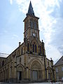 Assumption of Our Lady's Church
 -
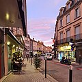 Main street running through the city centre


Twin towns and sister cities edit
 Göllheim, Germany
 Marano Equo, Italy
Notable people edit
- Jean-Claude Delamétherie (1743–1817), mineralogist, geologist, paleontologist, first mayor of La Clayette in 1790
- Joseph Jolinon (1885–1971), writer, recipient of the Grand Prix du Roman in 1950
- André Néron (1922–1985), mathematician, recipient of the Émile Picard Medal in 1983
See also edit
References edit
- ^ "Répertoire national des élus: les maires". data.gouv.fr, Plateforme ouverte des données publiques françaises (in French). 2 December 2020.
- ^ "Populations légales 2021". The National Institute of Statistics and Economic Studies. 28 December 2023.
- ^ Jean-Marie Pierret, Phonétique historique du français et notions de phonétique générale, Peeters, Louvain-la-Neuve, 1994, p. 104.
- ^ Le Pays Charolais-Brionnais : c'est où ? C'est quoi ?, Pays Charolais-Brionnais
- ^ "Histoire du Charolais - La Maison du Charolais". www.maison-charolais.com. Archived from the original on 2013-11-25.
- ^ "Notre candidature - Pays Charolais-brionnais". www.charolais-brionnais.fr. Archived from the original on 2014-07-10.
- ^ Population en historique depuis 1968, INSEE
- ^ Unité urbaine 2020 de la Clayette (71107), INSEE
- ^ "Château de la Clayette".