
KNOWPIA
WELCOME TO KNOWPIA

La Couture, Pas-de-Calais 
Summary
La Couture (French pronunciation: [la kutyʁ]; West Flemish: De Kouter) is a commune in the Pas-de-Calais department in the Hauts-de-France region of France.[3]
La Couture
De Kouter | |
|---|---|
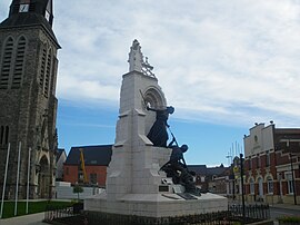 The church, war memorial and town hall of La Couture | |
 Coat of arms | |
Location of La Couture .mw-parser-output .locmap .od{position:absolute}.mw-parser-output .locmap .id{position:absolute;line-height:0}.mw-parser-output .locmap .l0{font-size:0;position:absolute}.mw-parser-output .locmap .pv{line-height:110%;position:absolute;text-align:center}.mw-parser-output .locmap .pl{line-height:110%;position:absolute;top:-0.75em;text-align:right}.mw-parser-output .locmap .pr{line-height:110%;position:absolute;top:-0.75em;text-align:left}.mw-parser-output .locmap .pv>div{display:inline;padding:1px}.mw-parser-output .locmap .pl>div{display:inline;padding:1px;float:right}.mw-parser-output .locmap .pr>div{display:inline;padding:1px;float:left}html.skin-theme-clientpref-night .mw-parser-output .od,html.skin-theme-clientpref-night .mw-parser-output .od .pv>div,html.skin-theme-clientpref-night .mw-parser-output .od .pl>div,html.skin-theme-clientpref-night .mw-parser-output .od .pr>div{background:#000;color:#fff}html.skin-theme-clientpref-night .mw-parser-output .locmap{filter:grayscale(0.6)}@media(prefers-color-scheme:dark){html.skin-theme-clientpref-os .mw-parser-output .locmap{filter:grayscale(0.6)}html.skin-theme-clientpref-os .mw-parser-output .od,html.skin-theme-clientpref-os .mw-parser-output .od .pv>div,html.skin-theme-clientpref-os .mw-parser-output .od .pl>div,html.skin-theme-clientpref-os .mw-parser-output .od .pr>div{background:#000;color:#fff}}  La Couture  La Couture | |
| Coordinates: 50°34′55″N 2°42′46″E / 50.5819°N 2.7128°E | |
| Country | France |
| Region | Hauts-de-France |
| Department | Pas-de-Calais |
| Arrondissement | Béthune |
| Canton | Beuvry |
| Intercommunality | CA Béthune-Bruay, Artois-Lys Romane |
| Government | |
| • Mayor (2020–2026) | Raymond Gaquère[1] |
| Area 1 | 13.52 km2 (5.22 sq mi) |
| Population (2021)[2] | 2,616 |
| • Density | 190/km2 (500/sq mi) |
| Time zone | UTC+01:00 (CET) |
| • Summer (DST) | UTC+02:00 (CEST) |
| INSEE/Postal code | 62252 /62136 |
| Elevation | 15–20 m (49–66 ft) (avg. 18 m or 59 ft) |
| 1 French Land Register data, which excludes lakes, ponds, glaciers > 1 km2 (0.386 sq mi or 247 acres) and river estuaries. | |
Geography edit
A large farming village, situated some 6 miles (9.7 km) northeast of Béthune and 18 miles (29 km) west of Lille at the junction of the D169 and the D170 roads.
Population edit
| Year | Pop. | ±% p.a. |
|---|---|---|
| 1968 | 1,327 | — |
| 1975 | 1,332 | +0.05% |
| 1982 | 1,666 | +3.25% |
| 1990 | 2,165 | +3.33% |
| 1999 | 2,249 | +0.42% |
| 2007 | 2,593 | +1.80% |
| 2012 | 2,712 | +0.90% |
| 2017 | 2,764 | +0.38% |
| Source: INSEE[4] | ||
Places of interest edit
- The church of St. Pierre, rebuilt along with the rest of the village. after World War I.
- The memorial to Portuguese soldiers of 1914–18.
See also edit
References edit
- ^ "Répertoire national des élus: les maires". data.gouv.fr, Plateforme ouverte des données publiques françaises (in French). 2 December 2020.
- ^ "Populations légales 2021". The National Institute of Statistics and Economic Studies. 28 December 2023.
- ^ INSEE commune file
- ^ Population en historique depuis 1968, INSEE
Wikimedia Commons has media related to La Couture (Pas-de-Calais).