


Summary
La Flotte (French pronunciation: [la flɔt]; sometimes locally La Flotte-en-Re), is a commune on the isle of Ré off the western coast of France, administratively part of the department of Charente-Maritime within the larger Nouvelle-Aquitaine region.[3]
La Flotte | |
|---|---|
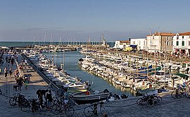 The harbour in La Flotte | |
 Coat of arms | |
Location of La Flotte .mw-parser-output .locmap .od{position:absolute}.mw-parser-output .locmap .id{position:absolute;line-height:0}.mw-parser-output .locmap .l0{font-size:0;position:absolute}.mw-parser-output .locmap .pv{line-height:110%;position:absolute;text-align:center}.mw-parser-output .locmap .pl{line-height:110%;position:absolute;top:-0.75em;text-align:right}.mw-parser-output .locmap .pr{line-height:110%;position:absolute;top:-0.75em;text-align:left}.mw-parser-output .locmap .pv>div{display:inline;padding:1px}.mw-parser-output .locmap .pl>div{display:inline;padding:1px;float:right}.mw-parser-output .locmap .pr>div{display:inline;padding:1px;float:left}html.skin-theme-clientpref-night .mw-parser-output .od,html.skin-theme-clientpref-night .mw-parser-output .od .pv>div,html.skin-theme-clientpref-night .mw-parser-output .od .pl>div,html.skin-theme-clientpref-night .mw-parser-output .od .pr>div{background:#000;color:#fff}html.skin-theme-clientpref-night .mw-parser-output .locmap{filter:grayscale(0.6)}@media(prefers-color-scheme:dark){html.skin-theme-clientpref-os .mw-parser-output .locmap{filter:grayscale(0.6)}html.skin-theme-clientpref-os .mw-parser-output .od,html.skin-theme-clientpref-os .mw-parser-output .od .pv>div,html.skin-theme-clientpref-os .mw-parser-output .od .pl>div,html.skin-theme-clientpref-os .mw-parser-output .od .pr>div{background:#000;color:#fff}}  La Flotte  La Flotte | |
| Coordinates: 46°11′16″N 1°19′28″W / 46.1878°N 1.3244°W | |
| Country | France |
| Region | Nouvelle-Aquitaine |
| Department | Charente-Maritime |
| Arrondissement | La Rochelle |
| Canton | Île de Ré |
| Intercommunality | Île de Ré |
| Government | |
| • Mayor (2020–2026) | Jean-Paul Heraudeau[1] |
| Area 1 | 12.32 km2 (4.76 sq mi) |
| Population (2021)[2] | 3,017 |
| • Density | 240/km2 (630/sq mi) |
| Demonym(s) | Flottais, Flottaises |
| Time zone | UTC+01:00 (CET) |
| • Summer (DST) | UTC+02:00 (CEST) |
| INSEE/Postal code | 17161 /17630 |
| Elevation | 0–17 m (0–56 ft) (avg. 8 m or 26 ft) |
| 1 French Land Register data, which excludes lakes, ponds, glaciers > 1 km2 (0.386 sq mi or 247 acres) and river estuaries. | |
It is the largest municipality on the Île de Ré by area, and the second largest by population, second to Sainte-Marie-de-Ré on the southern tip of the island.
La Flotte was declared one of the most beautiful villages in France by the eponymous independent tourism organization Les Plus Beaux Villages de France, and since 2011, the town has been a part of the departmental government's "Stone and Water Villages" tourism initiative to promote notable coastal and waterfront locales (i.e., where the stone (city) meets the water (sea, river etc.).
Geography edit
Town planning edit
The commune of La Flotte contains the town proper and a marina. La Flotte is an urban municipality, part of the urban unit of La Flotte, which also contains the commune of Saint-Martin-de-Ré.[4] In addition, the municipality is part of the attraction area of La Flotte, covering 4 communes.[3]
Coastline edit
The shoreline of La Flotte is bordered by small cliffs, and is home to Arnéult Beach, an artificial beach that has to be re-sanded each year.
As it is bordered by the Atlantic Ocean, La Flotte is a coastal municipality as defined by the Coastline Act (1986).[5] As a result specific town planning provisions apply in order to preserve the natural spaces, sites, landscapes and the ecological balance of the coast, including a prohibition on construction along the coastline.[6]
Land use edit
A sizable amount of the land in La Flotte is agricultural, 47% in 2018, down from 55.1% in 1990. The detailed breakdown in 2018 is as follows: forests (34.3%), permanent crops (18.3%), urbanized areas (17.9%), heterogeneous agricultural areas (15.9%), arable land (9.1%), meadows (3.7%), artificial green spaces, non-agricultural (0.5%), coastal wetlands (0.4%).[7]
Economic activity edit
- Agriculture, asparagus, potatoes, vine.
- Oyster farming, boating, fishing.
- Tourism. Accommodation: six hotels, five campsites, guest houses, seasonal rentals.
History edit
In 1627, an English invasion force under the command of George Villiers, Duke of Buckingham, attacked the island in order to relieve the Siege of La Rochelle. After three months of siege, the Marquis de Toiras and a relief force of French ships and troops managed to repel the Duke, who was forced to withdraw in defeat.[8] The English lost more than 4,000 out of 7,000 troops during the campaign. After repelling the English assault, the French Guards retreated through the town of La Flotte, and burned three English vessels there in the port and returned to Fort La Prée.
La Flotte was the home of Gustave Dechézeaux (1760-1794), a member of the National Convention. A victim of the Reign of Terror, he was guillotined at Rochefort on 17 January 1794 for his vote against the execution of Louis XVI.[9] He was later given a posthumous pardon by the Convention on 3 May 1795.[10]
Government edit
Mayors edit
| Term | Name | Occupation | ||
|---|---|---|---|---|
| 1790 | 1791 | Jean Henry-Laine | nobility | |
| 1791 | 1793 | N J. Brizard-Durocq | merchant | |
| 1793 | 1793 | Porsain Coursolle | merchant | |
| 1793 | 1794 | Joshua Sibille | nobility | |
| 1794 | 1796 | Hibry | merchant | |
| 1796 | 1802 | Jacques Louis Rateau | merchant | |
| 1802 | 1805 | Jean Pierre Derame | merchant | |
| 1805 | 1814 | Pierre Valleau | merchant | |
| 1815 | 1825 | Jean Pierre Derame | merchant | |
| 1826 | 1833 | John Hector Lem | landlord | |
| 1834 | 1837 | JJ Margotteau | merchant | |
| 1837 | 1852 | Adrian Ponsin | doctor | |
| 1852 | 1855 | Charles Villeneau | landlord | |
| 1855 | 1855* | Francois Maurice Gaussens | merchant | |
| 1855 | 1869 | Sebastien Sibille-Lavertu | notary | |
| 1869 | 1870 ** | Jean Emile Fourgnaud | doctor | |
| 1869 | 1870 ** | Marc Brin | merchant | |
| 1869 | 1870 ** | Etienne Margotteau | merchant | |
| 1870 | 1870 ** | Charles Biret | notary | |
| 1870 | 1871 | Jean Emile Fourgnaud | doctor | |
| 1871 | 1877 | Aimed Napoleon Bos | draper | |
| 1877 | 1878 | Charles Biret | notary | |
| 1878 | 1882 | Aimed Napoleon Bos | draper | |
| 1882 | 1896 | Camille Mague | landlord | |
| 1896 | 1928 | Charles Biret | notary | |
| 1928 | 1935 | Aristide Guignier | farmer | |
| 1935 | Gaston Lem | |||
| 1947 | 1952 | Eugene Chauffour | trader | |
| 1952 | 1959 | Pierre Brochard | retired officer | |
| 1959 | 1971 | Guy Margotteau | retired director of overseas France | |
| 1971 | 1977 | Raymond Poncet | oyster farmer | |
| 1977 | 2020 | Leon Gendre | hotelier, retired restaurateur, former general councilor | |
| 2020 | Present | Jean-Paul Héraudeau | ||
* For 1855, municipal councilor acting as mayor.
** For the year 1870, from 21st of October to July, (Fourgnaud, Brin, Margotteau, Biret) municipal commission | ||||
2008 municipal elections edit
| List driven by | Number of applicants | % | Voice (average of lists) | Elected |
|---|---|---|---|---|
| Leon Gendre | 23 | 52.6% | 1059 | 23 |
| Jean-Paul Héraudeau | 23 | 47.4% | 953 |
2001 municipal elections edit
| List driven by | Number of applicants | % | Voice (average of lists) | Elected |
|---|---|---|---|---|
| Leon Gendre | 23 | 100.0% | 1188 | 23 |
1995 municipal elections edit
| List driven by | Number of applicants | % | Voice (average of lists) | Elected |
|---|---|---|---|---|
| Leon Gendre | 23 | 52.0% | 824 | 15 |
| Raymond Grassineau | 23 | 48.0% | 760 | 8 |
1989 municipal elections edit
| List driven by | Number of applicants | % | Voice (average of lists) | Elected |
|---|---|---|---|---|
| Leon Gendre | 49.4% | 735 | ||
| James roy | 27.0% | 402 | ||
| Menanteau | 23.6% | 350 |
Demographics edit
In 2018, the town had 2,759 inhabitants, down 4.8% compared to 2013 (Charente-Maritime: + 2.13%, France excluding Mayotte: +1.78%).
|
| ||||||||||||||||||||||||||||||||||||||||||||||||||||||||||||||||||||||||||||||||||||||||||||||||||||||||||||||||||
| Source: EHESS[11] and INSEE (1968-2017)[12] | |||||||||||||||||||||||||||||||||||||||||||||||||||||||||||||||||||||||||||||||||||||||||||||||||||||||||||||||||||
Culture and heritage edit
Places and monuments edit
- The Port: formerly a commercial port for wine and salt, then a fishing port. It is essentially a marina today. Its capacity is 200 berths on pontoons and 150 berths in organized moorings.
- The ruins of the Cistercian Abbey of Notre-Dame-de-Ré (between Rivedoux-Plage and La Flotte). The site has been classified as a “historic monument” since 21 May 1990.
- The Fort La Pree, built in 1625 and partially destroyed by Vauban in 1685.
- The Medieval Market.
- The Platin Museum, which has collections related to regional culture, Medieval architecture, and maritime history.[13]
- The Church of St. Catherine Fleet (or "Church of St. Catherine of Alexandria") Built in the 15th century. Listed, in part, as a Historic Monument, in 1988.
Heraldry edit
Notable people edit
- Nicolas Martiau (1591-1657), Huguenot settler, ancestor of George Washington and Robert E. Lee.
- Denis Goguet (1704-1778), merchant and shipowner
- Gustave Dechézeaux (1760-1794), French politician. Member of the National Convention, guillotined in 1794 during the Reign of Terror "for having conspired against the Republic", then posthumously pardoned in 1795.
- Jacques Gilles Henri Goguet (1767-1794), General
- Léon Gendre, general councilor of the canton of Saint-Martin-de-Ré (reelected in 2011), president of the Community of communes of the island of Ré from 1993 to 2008, mayor of La Flotte since 1977, ex-restaurateur (creator of the restaurant Le Richelieu).
- Roger Barberot (1915-2002) - Companion of the Liberation by decree of 7 March 1941, the most decorated sailor in France.
See also edit
References edit
- ^ "Répertoire national des élus: les maires". data.gouv.fr, Plateforme ouverte des données publiques françaises (in French). 9 August 2021.
- ^ "Populations légales 2021". The National Institute of Statistics and Economic Studies. 28 December 2023.
- ^ a b Commune de La Flotte (17161), INSEE
- ^ Unité urbaine 2020 de la Flotte (17130), INSEE
- ^ Loi n° 86-2 du 1986-01-03 The Coastline Act
- ^ Bordereaux*, Laurent (10 September 2014). "Seashore Law: The Core of French Public Maritime Law". The International Journal of Marine and Coastal Law. 29 (3): 402–414. doi:10.1163/15718085-12341312. ISSN 0927-3522.
- ^ "CLC 2018 — Copernicus Land Monitoring Service". land.copernicus.eu. Retrieved 13 May 2023.
- ^ Fissel, p.123
- ^ Réveillaud, Eugène (1851-1935) Auteur du texte (1911). Histoire politique et parlementaire des départements de la Charente et de la Charente-Inférieure : de 1789 à 1830 / par Eug. Réveillaud,... pp. 362–70. Retrieved 13 May 2023.
{{cite book}}: CS1 maint: numeric names: authors list (link) - ^ Ballard, Richard (2010). The Unseen Terror : The French Revolution in the Provinces. p. 105. ISBN 9781848853256.
- ^ Des villages de Cassini aux communes d'aujourd'hui: Commune data sheet La Flotte, EHESS (in French).
- ^ Population en historique depuis 1968, INSEE
- ^ "Les collections". Musée du Platin (in French).
External links edit
 Media related to La Flotte at Wikimedia Commons