
KNOWPIA
WELCOME TO KNOWPIA

La Neuville-Chant-d'Oisel 
Summary
La Neuville-Chant-d'Oisel is a commune in the Seine-Maritime department in the Normandy region in north-western France.
La Neuville-Chant-d'Oisel | |
|---|---|
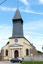 The church in La Neuville-Chant-d'Oisel | |
Location of La Neuville-Chant-d'Oisel .mw-parser-output .locmap .od{position:absolute}.mw-parser-output .locmap .id{position:absolute;line-height:0}.mw-parser-output .locmap .l0{font-size:0;position:absolute}.mw-parser-output .locmap .pv{line-height:110%;position:absolute;text-align:center}.mw-parser-output .locmap .pl{line-height:110%;position:absolute;top:-0.75em;text-align:right}.mw-parser-output .locmap .pr{line-height:110%;position:absolute;top:-0.75em;text-align:left}.mw-parser-output .locmap .pv>div{display:inline;padding:1px}.mw-parser-output .locmap .pl>div{display:inline;padding:1px;float:right}.mw-parser-output .locmap .pr>div{display:inline;padding:1px;float:left}html.skin-theme-clientpref-night .mw-parser-output .od,html.skin-theme-clientpref-night .mw-parser-output .od .pv>div,html.skin-theme-clientpref-night .mw-parser-output .od .pl>div,html.skin-theme-clientpref-night .mw-parser-output .od .pr>div{background:#000;color:#fff}html.skin-theme-clientpref-night .mw-parser-output .locmap{filter:grayscale(0.6)}@media(prefers-color-scheme:dark){html.skin-theme-clientpref-os .mw-parser-output .locmap{filter:grayscale(0.6)}html.skin-theme-clientpref-os .mw-parser-output .od,html.skin-theme-clientpref-os .mw-parser-output .od .pv>div,html.skin-theme-clientpref-os .mw-parser-output .od .pl>div,html.skin-theme-clientpref-os .mw-parser-output .od .pr>div{background:#000;color:#fff}}  La Neuville-Chant-d'Oisel  La Neuville-Chant-d'Oisel | |
| Coordinates: 49°22′07″N 1°14′38″E / 49.3686°N 1.2439°E | |
| Country | France |
| Region | Normandy |
| Department | Seine-Maritime |
| Arrondissement | Rouen |
| Canton | Le Mesnil-Esnard |
| Intercommunality | Métropole Rouen Normandie |
| Government | |
| • Mayor (2020–2026) | Julien Demazure[1] |
| Area 1 | 21.83 km2 (8.43 sq mi) |
| Population (2021)[2] | 2,377 |
| • Density | 110/km2 (280/sq mi) |
| Time zone | UTC+01:00 (CET) |
| • Summer (DST) | UTC+02:00 (CEST) |
| INSEE/Postal code | 76464 /76520 |
| Elevation | 74–162 m (243–531 ft) (avg. 168 m or 551 ft) |
| 1 French Land Register data, which excludes lakes, ponds, glaciers > 1 km2 (0.386 sq mi or 247 acres) and river estuaries. | |
Geography edit
A village of forestry and farming situated some 10 miles (16 km) southeast of Rouen, at the junction of the D 13, D 138 and the D 294 roads. The commune is on the border with the department of Eure.
Population edit
| Year | Pop. | ±% p.a. |
|---|---|---|
| 1793 | 1,447 | — |
| 1861 | 1,306 | −0.15% |
| 1921 | 748 | −0.92% |
| 1962 | 856 | +0.33% |
| 1968 | 896 | +0.76% |
| 1975 | 1,048 | +2.26% |
| 1982 | 1,362 | +3.81% |
| 1990 | 1,691 | +2.74% |
| 1999 | 1,751 | +0.39% |
| 2007 | 1,918 | +1.15% |
| 2012 | 2,228 | +3.04% |
| 2017 | 2,240 | +0.11% |
| Source: EHESS[3] and INSEE (1968-2017)[4] | ||
Places of interest edit
- A memorial to cyclist Jacques Anquetil, who lived here.
- The church of Notre-Dame, dating from the thirteenth century.
- The church of St.Austin dating from the sixteenth century at St. Austin.
- Two châteaux, at La Neuville and at Chant-d'Oisel.
- A house once owned by writer Guy de Maupassant and later by cyclist Jacques Anquetil.
- A seventeenth-century stone cross at the cross-roads.
See also edit
References edit
- ^ "Répertoire national des élus: les maires" (in French). data.gouv.fr, Plateforme ouverte des données publiques françaises. 13 September 2022.
- ^ "Populations légales 2021". The National Institute of Statistics and Economic Studies. 28 December 2023.
- ^ Des villages de Cassini aux communes d'aujourd'hui: Commune data sheet La Neuville-Chant-d'Oisel, EHESS (in French).
- ^ Population en historique depuis 1968, INSEE
External links edit
Wikimedia Commons has media related to La Neuville-Chant-d'Oisel.
- Official website of Neuville-Chant-d'Oisel (in French)