
KNOWPIA
WELCOME TO KNOWPIA

La Pintada, Antioquia 
Summary
La Pintada (Spanish pronunciation: [la pinˈtaða]); is a town and municipality in the southwest region of the Antioquia department. It is located 79 miles from Medellín at an altitude of 600 m (2,000 ft) above sea level. It borders the Fredonia and Santa Bárbara municipalities to the north. The Cauca River flows through the municipality.
La Pintada | |
|---|---|
Municipality and town | |
 | |
 Flag | |
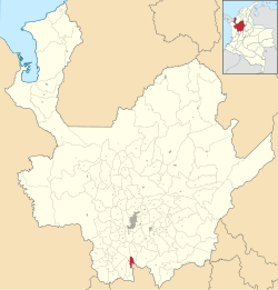 Location of the municipality and town of La Pintada in the Antioquia Department of Colombia | |
 La Pintada Location in Colombia | |
| Coordinates: 5°44′31″N 75°36′19″W / 5.74194°N 75.60528°W | |
| Country | |
| Department | |
| Subregion | Southwestern |
| Elevation | 600 m (2,000 ft) |
| Time zone | UTC-5 (Colombia Standard Time) |
Places of interest edit
- Slopes of the Poblanco and Arma rivers
- Yellow hill
- Alejandro López railway station
- El Salto del Caballo
- Acapulco beach
Gallery edit
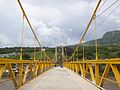
Wikimedia Commons has media related to La Pintada.
5°45′N 75°36′W / 5.750°N 75.600°W