


Summary
Lake Mulwala, a man-made reservoir created through the construction of the Yarrawonga Weir across the Murray River, is located between Bundalong and Yarrawonga in Hume region of Victoria and Mulwala in the Riverina region of New South Wales, in eastern Australia. The weir was constructed in 1939 to provide water for irrigation in the surrounding district. The weir also serves as a crossing of the Murray between the two towns; in addition to the crossing located via the Mulwala Bridge.
| Lake Mulwala | |
|---|---|
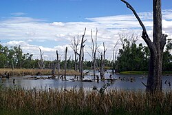 A view of the eastern end of the lake | |
 Lake Mulwala | |
| Location | |
| Coordinates | 36°00′S 146°05′E / 36.000°S 146.083°E |
| Type | Reservoir |
| Primary inflows | Murray River; Ovens River |
| Primary outflows | Murray River |
| Basin countries | Australia |
| Surface area | 43,900 ha (108,000 acres) |
| Surface elevation | 124.9 m (410 ft) AHD |
| References | [1][2] |
Location and features edit


The road bridge across the lake was built before the lake was filled, commenced in 1917, and completed in 1924. It replaced an earlier wooden bridge built in 1889–1891. The bridge was started from both ends, each by the respective state government. However, they did not coordinate their efforts, and the bridge has a dip and a bend in the middle to make the two ends meet.[3]
The Yarrawonga Weir is the farthest downstream obstruction across the Murray that does not have a navigation lock through it. When full, the lake is 124.9 metres (410 ft) above sea level. The weir is 1,992 kilometres (1,238 mi) upriver from the river mouth.
Lake Mulwala is a renowned fishery for the native Murray cod and is one of the few places where this Australian native freshwater fish is still reasonably common.[citation needed]
See also edit
References edit
- ^ "Register of Large Dams in Australia". Dams information. Australian National Committee on Large Dams. 2010. Archived from the original (Excel (requires download)) on 12 December 2013. Retrieved 29 October 2014.
- ^ "Map of Lake Mulwala". Bonzle Digital Atlas of Australia. 2014. Retrieved 29 October 2014.
- ^ "The Yarrawonga Mulwala Story". Yarrawonga Mulwala Tourism Inc. Archived from the original on 20 March 2012. Retrieved 9 February 2012.
{{cite web}}: CS1 maint: bot: original URL status unknown (link)
External links edit
- Yarrawonga - Mulwala tourism