
KNOWPIA
WELCOME TO KNOWPIA

Lake Schwerin 
Summary
Lake Schwerin[1][2] (German: Schweriner See) is a lake in Mecklenburg-Vorpommern, northern Germany. It was named after the city Schwerin, on its southwestern shore. The smaller town Bad Kleinen is on the north shore of the lake. Its surface is approximately 61.54 square kilometres (23.76 sq mi), and its maximum depth is 52.4 metres (172 ft). The natural outflow of the lake is the (channelized) river Stör, a tributary of the Elde, and part of the Elbe watershed. The Wallensteingraben, a 16th-century canal, connects the lake with the Baltic Sea at Wismar.
| Lake Schwerin | |
|---|---|
| Schweriner See (German) | |
 | |
 Lake Schwerin  Lake Schwerin | |
| Location | Mecklenburg-Western Pomerania |
| Coordinates | 53°38′N 11°28′E / 53.633°N 11.467°E |
| Type | eutrophic |
| Primary outflows | Wallensteingraben, Stör Canal |
| Basin countries | Germany |
| Max. length | 21 km (13 mi) |
| Max. width | 6 km (3.7 mi) |
| Surface area | 61.54 km2 (23.76 sq mi) |
| Average depth | 12.8 m (42 ft) |
| Max. depth | 52.4 m (172 ft) |
| Residence time | 10.1 years |
| Surface elevation | 37.6 m (123 ft) |
| Settlements | Schwerin, Bad Kleinen |
Gallery edit
-
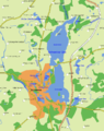 Map of Schwerin and its lakes, most dominantly the Lake Schwerin with its inner and outer lake area
 -
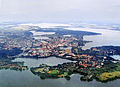 Aerial view of Schwerin on the lakes
 -
 Schwerin Castle on its own island in the Lake Schwerin
 -
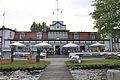 Yachting Club at Lake Schwerin
 -
 White Fleet, cruiseships at the city's lakeshore
 -
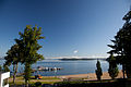
 Beach in Zippendorf, a district of Schwerin
 -
 The Beutel are of Lake Schwerin
 -
 Sunrise at the Marstall peninsula
 -
 Schwerin seen from the Lake
 -
 Observation tower on Kaninchenwerder, an island of Lake Schwerin
 -
 Sunrise at Ziegelwerder island


References edit
External links edit
 Media related to Schweriner See at Wikimedia Commons
- Nixdorf, B.; et al. (2004), "Schweriner See", Dokumentation von Zustand und Entwicklung der wichtigsten Seen Deutschlands (in German), Berlin: Umweltbundesamt, p. 265