
KNOWPIA
WELCOME TO KNOWPIA

Lallaing 
Summary
Lallaing (French pronunciation: [lalɛ̃]) is a commune in the Nord department in northern France.[3]
Lallaing | |
|---|---|
 The town hall in Lallaing | |
 Coat of arms | |
Location of Lallaing .mw-parser-output .locmap .od{position:absolute}.mw-parser-output .locmap .id{position:absolute;line-height:0}.mw-parser-output .locmap .l0{font-size:0;position:absolute}.mw-parser-output .locmap .pv{line-height:110%;position:absolute;text-align:center}.mw-parser-output .locmap .pl{line-height:110%;position:absolute;top:-0.75em;text-align:right}.mw-parser-output .locmap .pr{line-height:110%;position:absolute;top:-0.75em;text-align:left}.mw-parser-output .locmap .pv>div{display:inline;padding:1px}.mw-parser-output .locmap .pl>div{display:inline;padding:1px;float:right}.mw-parser-output .locmap .pr>div{display:inline;padding:1px;float:left}html.skin-theme-clientpref-night .mw-parser-output .od,html.skin-theme-clientpref-night .mw-parser-output .od .pv>div,html.skin-theme-clientpref-night .mw-parser-output .od .pl>div,html.skin-theme-clientpref-night .mw-parser-output .od .pr>div{background:#000;color:#fff}html.skin-theme-clientpref-night .mw-parser-output .locmap{filter:grayscale(0.6)}@media(prefers-color-scheme:dark){html.skin-theme-clientpref-os .mw-parser-output .locmap{filter:grayscale(0.6)}html.skin-theme-clientpref-os .mw-parser-output .od,html.skin-theme-clientpref-os .mw-parser-output .od .pv>div,html.skin-theme-clientpref-os .mw-parser-output .od .pl>div,html.skin-theme-clientpref-os .mw-parser-output .od .pr>div{background:#000;color:#fff}}  Lallaing  Lallaing | |
| Coordinates: 50°23′24″N 3°10′08″E / 50.390°N 3.169°E | |
| Country | France |
| Region | Hauts-de-France |
| Department | Nord |
| Arrondissement | Douai |
| Canton | Sin-le-Noble |
| Intercommunality | Douaisis Agglo |
| Government | |
| • Mayor (2020–2026) | Jean-Paul Fontaine[1] |
| Area 1 | 5.99 km2 (2.31 sq mi) |
| Population (2021)[2] | 6,250 |
| • Density | 1,000/km2 (2,700/sq mi) |
| Time zone | UTC+01:00 (CET) |
| • Summer (DST) | UTC+02:00 (CEST) |
| INSEE/Postal code | 59327 /59167 |
| Elevation | 16–30 m (52–98 ft) (avg. 20 m or 66 ft) |
| 1 French Land Register data, which excludes lakes, ponds, glaciers > 1 km2 (0.386 sq mi or 247 acres) and river estuaries. | |
Population edit
| Year | Pop. | ±% p.a. |
|---|---|---|
| 1968 | 8,813 | — |
| 1975 | 8,399 | −0.69% |
| 1982 | 8,174 | −0.39% |
| 1990 | 8,001 | −0.27% |
| 1999 | 6,999 | −1.48% |
| 2007 | 6,533 | −0.86% |
| 2012 | 6,405 | −0.39% |
| 2017 | 6,231 | −0.55% |
| Source: INSEE[4] | ||
Heraldry edit
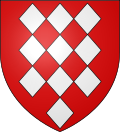 |
The arms of Lallaing are blazoned: Gules, 10 lozenges conjoined argent 3,3,3 and 1. (Fressain, Hergnies, Lallaing and Marpent use the same arms.)
|
See also edit
References edit
- ^ "Répertoire national des élus: les maires". data.gouv.fr, Plateforme ouverte des données publiques françaises (in French). 2 December 2020.
- ^ "Populations légales 2021". The National Institute of Statistics and Economic Studies. 28 December 2023.
- ^ INSEE commune file
- ^ Population en historique depuis 1968, INSEE
External links edit
 Media related to Lallaing at Wikimedia Commons