
KNOWPIA
WELCOME TO KNOWPIA

Lamballe-Armor 
Summary
Lamballe-Armor (French pronunciation: [lɑ̃bal aʁmɔʁ]) is a commune in the Côtes-d'Armor department in Brittany in northwestern France. It was established on 1 January 2019 by merger of the former communes of Lamballe (the seat), Morieux and Planguenoual.[3]
Lamballe-Armor | |
|---|---|
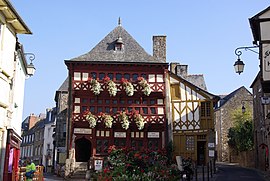 The Lamballe Museum | |
Location of Lamballe-Armor .mw-parser-output .locmap .od{position:absolute}.mw-parser-output .locmap .id{position:absolute;line-height:0}.mw-parser-output .locmap .l0{font-size:0;position:absolute}.mw-parser-output .locmap .pv{line-height:110%;position:absolute;text-align:center}.mw-parser-output .locmap .pl{line-height:110%;position:absolute;top:-0.75em;text-align:right}.mw-parser-output .locmap .pr{line-height:110%;position:absolute;top:-0.75em;text-align:left}.mw-parser-output .locmap .pv>div{display:inline;padding:1px}.mw-parser-output .locmap .pl>div{display:inline;padding:1px;float:right}.mw-parser-output .locmap .pr>div{display:inline;padding:1px;float:left}html.skin-theme-clientpref-night .mw-parser-output .od,html.skin-theme-clientpref-night .mw-parser-output .od .pv>div,html.skin-theme-clientpref-night .mw-parser-output .od .pl>div,html.skin-theme-clientpref-night .mw-parser-output .od .pr>div{background:#000;color:#fff}html.skin-theme-clientpref-night .mw-parser-output .locmap{filter:grayscale(0.6)}@media(prefers-color-scheme:dark){html.skin-theme-clientpref-os .mw-parser-output .locmap{filter:grayscale(0.6)}html.skin-theme-clientpref-os .mw-parser-output .od,html.skin-theme-clientpref-os .mw-parser-output .od .pv>div,html.skin-theme-clientpref-os .mw-parser-output .od .pl>div,html.skin-theme-clientpref-os .mw-parser-output .od .pr>div{background:#000;color:#fff}}  Lamballe-Armor  Lamballe-Armor | |
| Coordinates: 48°28′10″N 2°31′00″W / 48.4694°N 2.5167°W | |
| Country | France |
| Region | Brittany |
| Department | Côtes-d'Armor |
| Arrondissement | Saint-Brieuc |
| Canton | Lamballe-Armor and Pléneuf-Val-André |
| Intercommunality | CA Lamballe Terre et Mer |
| Government | |
| • Mayor (2020–2026) | Philippe Hercouët[1] |
| Area 1 | 130.65 km2 (50.44 sq mi) |
| Population (2021)[2] | 16,845 |
| • Density | 130/km2 (330/sq mi) |
| Time zone | UTC+01:00 (CET) |
| • Summer (DST) | UTC+02:00 (CEST) |
| INSEE/Postal code | 22093 /22400 |
| Elevation | 0–131 m (0–430 ft) |
| 1 French Land Register data, which excludes lakes, ponds, glaciers > 1 km2 (0.386 sq mi or 247 acres) and river estuaries. | |
Population edit
| Year | Pop. | ±% p.a. |
|---|---|---|
| 1968 | 11,638 | — |
| 1975 | 11,799 | +0.20% |
| 1982 | 12,195 | +0.47% |
| 1990 | 12,732 | +0.54% |
| 1999 | 13,578 | +0.72% |
| 2007 | 14,782 | +1.07% |
| 2012 | 16,405 | +2.11% |
| 2017 | 16,578 | +0.21% |
| Populations of the area corresponding with the commune of Lamballe-Armor at 1 January 2020. Source: INSEE[4] | ||
References edit
- ^ "Répertoire national des élus: les maires" (in French). data.gouv.fr, Plateforme ouverte des données publiques françaises. 13 September 2022.
- ^ "Populations légales 2021". The National Institute of Statistics and Economic Studies. 28 December 2023.
- ^ Arrêté préfectoral 31 October 2018 (in French)
- ^ Population en historique depuis 1968, INSEE
Wikimedia Commons has media related to Lamballe-Armor.