


Summary
Lamotrek is a coral atoll of three islands in the central Caroline Islands in the Pacific Ocean, and forms a legislative district in Yap State in the Federated States of Micronesia. The atoll is located approximately 11 kilometers (6.8 mi) east of Elato. The population of Lamotrek was 373 in 2000,[1] living on almost 1 km2.
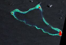 NASA picture with the three islands in red | |
 | |
| Geography | |
|---|---|
| Location | North Pacific |
| Coordinates | 7°29′N 146°20′E / 7.483°N 146.333°E |
| Archipelago | Caroline |
| Total islands | 3 |
| Area | 0.982 km2 (0.379 sq mi) |
| Highest elevation | 2 m (7 ft) |
| Administration | |
| Demographics | |
| Population | 373 (2000) |
| Ethnic groups | Micronesian |

Geography edit
The atoll is 11.5 kilometers (7.1 mi) long northeast-southeast, and up to 6.5 kilometers (4.0 mi) wide. Its total land area is only 0.982 square kilometers (0.379 sq mi), but it encloses a lagoon of 32 square kilometers (12 sq mi).[2]
Among the individual islets are the following:
- Falaite (northwest)
- Pugue (northeast)
- Lamotrek (southeast)
History edit
Before European rule, Lamotrek was invaded by Ifalik during Mweoiush's reign, with aid from the Mailiyas.
In January 1849 an earthquake occurred causing a flood to submerge the island with the exception of some trees. People climb trees to survive. The water however swept away people in certain cases who climb the trees causing them to die. Forty-one survivors came to the Marianas to permanently settle there in April of that year.[3]
As with all of the Caroline Islands, sovereignty passed to the Empire of Germany in 1899. The island came under the control of the Empire of Japan after World War I, and was subsequently administered under the South Seas Mandate. Following World War II, the island came under the control of the United States of America and was administered as part of the Trust Territory of the Pacific Islands from 1947, and became part of the Federated States of Micronesia from 1979.
Further reading edit
References edit
- Columbia Gazetteer of the World. Vol. 1, p. 900
- ^ Yap State Census Report, 2000 ( PDF)
- ^ "Oceandots". Archived from the original on December 23, 2010. Retrieved 2010-09-12.
{{cite web}}: CS1 maint: bot: original URL status unknown (link) - ^ Driver, Marjorie; Brunal-Perry, Omaira (1996). Carolinians in the Mariana Islands in the 1800s: selected documents from the holdings of the Spanish Documents Collection at the Micronesian Area Research Center: English-Spanish Edition (English-Spanish ed.) (English-Spanish ed.). Guam: Micronesian Area Research Center. ISBN 1-878453-21-1.
External links edit
- Entry at Oceandots.com at the Wayback Machine (archived December 23, 2010)
- Lamotrek Site on Triton Films