
KNOWPIA
WELCOME TO KNOWPIA

Landriano 
Summary
Landriano is a comune (municipality) in the Province of Pavia in the Italian region Lombardy, located about 20 kilometres (12 mi) southeast of Milan and about 15 kilometres (9 mi) northeast of Pavia.
Landriano | |
|---|---|
| Comune di Landriano | |
 | |
 Coat of arms | |
Location of Landriano .mw-parser-output .locmap .od{position:absolute}.mw-parser-output .locmap .id{position:absolute;line-height:0}.mw-parser-output .locmap .l0{font-size:0;position:absolute}.mw-parser-output .locmap .pv{line-height:110%;position:absolute;text-align:center}.mw-parser-output .locmap .pl{line-height:110%;position:absolute;top:-0.75em;text-align:right}.mw-parser-output .locmap .pr{line-height:110%;position:absolute;top:-0.75em;text-align:left}.mw-parser-output .locmap .pv>div{display:inline;padding:1px}.mw-parser-output .locmap .pl>div{display:inline;padding:1px;float:right}.mw-parser-output .locmap .pr>div{display:inline;padding:1px;float:left}html.skin-theme-clientpref-night .mw-parser-output .od,html.skin-theme-clientpref-night .mw-parser-output .od .pv>div,html.skin-theme-clientpref-night .mw-parser-output .od .pl>div,html.skin-theme-clientpref-night .mw-parser-output .od .pr>div{background:#000;color:#fff}html.skin-theme-clientpref-night .mw-parser-output .locmap{filter:grayscale(0.6)}@media(prefers-color-scheme:dark){html.skin-theme-clientpref-os .mw-parser-output .locmap{filter:grayscale(0.6)}html.skin-theme-clientpref-os .mw-parser-output .od,html.skin-theme-clientpref-os .mw-parser-output .od .pv>div,html.skin-theme-clientpref-os .mw-parser-output .od .pl>div,html.skin-theme-clientpref-os .mw-parser-output .od .pr>div{background:#000;color:#fff}}  Landriano Location of Landriano in Italy  Landriano Landriano (Lombardy) | |
| Coordinates: 45°19′N 9°16′E / 45.317°N 9.267°E | |
| Country | Italy |
| Region | Lombardy |
| Province | Pavia (PV) |
| Government | |
| • Mayor | Maria Ivana Vacchini |
| Area | |
| • Total | 15.59 km2 (6.02 sq mi) |
| Elevation | 88 m (289 ft) |
| Population | |
| • Total | 6,384 |
| • Density | 410/km2 (1,100/sq mi) |
| Demonym | Landrianini |
| Time zone | UTC+1 (CET) |
| • Summer (DST) | UTC+2 (CEST) |
| Postal code | 27015 |
| Dialing code | 0382 |
| Website | Official website |
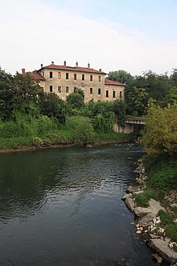
Landriano borders the following municipalities: Bascapè, Carpiano, Siziano, Torrevecchia Pia and Vidigulfo. It is located on the left shore of the Lambro, which here forms an islet which is the site of the old town's castle.
In 1529 it was the location of the battle of Landriano between France and Spain.
References edit
External links edit
- Official website