


Summary
Langonnet (Breton: Langoned) is a commune in the Morbihan department of Brittany in north-western France.[3]
Langonnet
Langoned | |
|---|---|
 The Church of Saint-Pierre-et-Saint-Paul, in Langonnet | |
 Coat of arms | |
Location of Langonnet .mw-parser-output .locmap .od{position:absolute}.mw-parser-output .locmap .id{position:absolute;line-height:0}.mw-parser-output .locmap .l0{font-size:0;position:absolute}.mw-parser-output .locmap .pv{line-height:110%;position:absolute;text-align:center}.mw-parser-output .locmap .pl{line-height:110%;position:absolute;top:-0.75em;text-align:right}.mw-parser-output .locmap .pr{line-height:110%;position:absolute;top:-0.75em;text-align:left}.mw-parser-output .locmap .pv>div{display:inline;padding:1px}.mw-parser-output .locmap .pl>div{display:inline;padding:1px;float:right}.mw-parser-output .locmap .pr>div{display:inline;padding:1px;float:left}html.skin-theme-clientpref-night .mw-parser-output .od,html.skin-theme-clientpref-night .mw-parser-output .od .pv>div,html.skin-theme-clientpref-night .mw-parser-output .od .pl>div,html.skin-theme-clientpref-night .mw-parser-output .od .pr>div{background:#000;color:#fff}html.skin-theme-clientpref-night .mw-parser-output .locmap{filter:grayscale(0.6)}@media(prefers-color-scheme:dark){html.skin-theme-clientpref-os .mw-parser-output .locmap{filter:grayscale(0.6)}html.skin-theme-clientpref-os .mw-parser-output .od,html.skin-theme-clientpref-os .mw-parser-output .od .pv>div,html.skin-theme-clientpref-os .mw-parser-output .od .pl>div,html.skin-theme-clientpref-os .mw-parser-output .od .pr>div{background:#000;color:#fff}}  Langonnet  Langonnet | |
| Coordinates: 48°06′23″N 3°29′32″W / 48.1064°N 3.4922°W | |
| Country | France |
| Region | Brittany |
| Department | Morbihan |
| Arrondissement | Pontivy |
| Canton | Gourin |
| Intercommunality | Roi Morvan Communauté |
| Government | |
| • Mayor (2020–2026) | Françoise Guillerm[1] |
| Area 1 | 85.40 km2 (32.97 sq mi) |
| Population (2021)[2] | 1,771 |
| • Density | 21/km2 (54/sq mi) |
| Time zone | UTC+01:00 (CET) |
| • Summer (DST) | UTC+02:00 (CEST) |
| INSEE/Postal code | 56100 /56630 |
| Elevation | 104–292 m (341–958 ft) |
| 1 French Land Register data, which excludes lakes, ponds, glaciers > 1 km2 (0.386 sq mi or 247 acres) and river estuaries. | |
Geography edit
Langonnet is in north-west part of Cornouaille, in Lower Brittany. It's one of the few Cornouaille parishes that are now in the Morbihan department. Thus the main language was the Breton language until the advent of intensive farming after the second world war at which point the people, who were bilingual, switched to the French language.
The parish holds two main human settlements:
- the actual town of Langonnet in the south
- the town of La Trinité-Langonnet in north-east
In the south-east there's the Notre-Dame de Langonnet abbey.
Topography edit
The highest point of the parish the calotte Saint Joseph, a round hill whose top is at 292 meters. It offers a nice view over the surrounding area (most of the parish is at 190 meter level).
Neighboring communes edit
Langonnet is border by Plouray and Priziac to the east, by Le Faouët to the south, by Le Saint and Gourin to the west and by Tréogan, Plévin, Paule and Glomel to the north.
Map edit

Toponymy edit
Its Breton name is written Langoned in modern breton but it has been written differently along the years (because of different tentatives to transcribe the Breton phonetic system with the Latin alphabet):
- XIe siècle : (Lan)Chunuett
- 1152 : Langenoit
- 1161 : Langonio
- 1168 : Lanngonio
- 1301 : Lenguenet
- 1368 : Langonec
- 1368 : Langonio
- 1373 : Languenec
- 1516 : Langonet
- 1516 : Langonio
- 1536 : Langonnet
- 1574 : Langonec
- 1630 : Langouet
- Today: Langoned
The Langoned name is said to come from Lann-Conet, the monastery (See lan in Breton, llan in welsh language) of Conet[4] (or Conoit, Konoed, Kon(n)ed, Konoid = Cynwyd, Kynwyd or Kynyd in welsh), a Welsh saint that came in Brittany.
Demographics edit
Inhabitants of Langonnet are called in French Langonnetais, in Breton Langonediz. Langonnet's population peaked at 4,848 in 1931 and declined to 1,708 in 2020. This represents a 65% decrease in total population since the peak census figure.
|
|
| ||||||||||||||||||||||||||||||||||||||||||||||||||||||||||||||||||||||||||||||||||||||||||||||||||||||||||||||||||
| Source: EHESS[5] and INSEE (1968-2020)[6] | ||||||||||||||||||||||||||||||||||||||||||||||||||||||||||||||||||||||||||||||||||||||||||||||||||||||||||||||||||||
Breton language edit
The municipality launched a linguistic plan through Ya d'ar brezhoneg on 27 January 2005.
Gallery edit
Landscapes edit
-
 The calotte Saint Joseph, highest peak of the village
 -
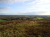 Panoramic view from the top of the Calotte Saint-Joseph
 -
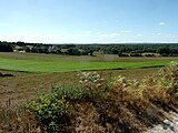 Panoramic view from the top of the Minez Collobert


See also edit
References edit
- ^ "Maires du Morbihan" (PDF). Préfecture du Morbihan. 7 July 2020.
- ^ "Populations légales 2021". The National Institute of Statistics and Economic Studies. 28 December 2023.
- ^ INSEE commune file
- ^ Orme, Nicholas (2000). OUP Oxford (ed.). The Saints of Cornwall. Oxford. p. 93. ISBN 0-19-820765-4.
{{cite book}}: CS1 maint: location missing publisher (link) - ^ Des villages de Cassini aux communes d'aujourd'hui: Commune data sheet Langonnet, EHESS (in French).
- ^ Population en historique depuis 1968, INSEE
External links edit
- Official site (in French)
- Base Mérimée: Search for heritage in the commune, Ministère français de la Culture. (in French)
- Mayors of Morbihan Association (in French)