
KNOWPIA
WELCOME TO KNOWPIA

Lantawan 
Summary
Lantawan, officially the Municipality of Lantawan (Tausūg: Lupah Lantawan; Chavacano: Municipalidad de Lantawan; Tagalog: Bayan ng Lantawan), is a 3rd class municipality in the province of Basilan, Philippines. According to the 2020 census, it has a population of 31,040 people.[3]
Lantawan
لنتاون | |
|---|---|
| Municipality of Lantawan | |
 Flag  Seal | |
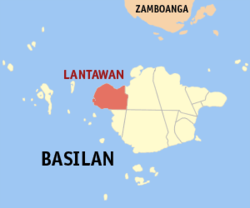 Map of Basilan with Lantawan highlighted | |
OpenStreetMap .mw-parser-output .locmap .od{position:absolute}.mw-parser-output .locmap .id{position:absolute;line-height:0}.mw-parser-output .locmap .l0{font-size:0;position:absolute}.mw-parser-output .locmap .pv{line-height:110%;position:absolute;text-align:center}.mw-parser-output .locmap .pl{line-height:110%;position:absolute;top:-0.75em;text-align:right}.mw-parser-output .locmap .pr{line-height:110%;position:absolute;top:-0.75em;text-align:left}.mw-parser-output .locmap .pv>div{display:inline;padding:1px}.mw-parser-output .locmap .pl>div{display:inline;padding:1px;float:right}.mw-parser-output .locmap .pr>div{display:inline;padding:1px;float:left}html.skin-theme-clientpref-night .mw-parser-output .od,html.skin-theme-clientpref-night .mw-parser-output .od .pv>div,html.skin-theme-clientpref-night .mw-parser-output .od .pl>div,html.skin-theme-clientpref-night .mw-parser-output .od .pr>div{background:#000;color:#fff}html.skin-theme-clientpref-night .mw-parser-output .locmap{filter:grayscale(0.6)}@media(prefers-color-scheme:dark){html.skin-theme-clientpref-os .mw-parser-output .locmap{filter:grayscale(0.6)}html.skin-theme-clientpref-os .mw-parser-output .od,html.skin-theme-clientpref-os .mw-parser-output .od .pv>div,html.skin-theme-clientpref-os .mw-parser-output .od .pl>div,html.skin-theme-clientpref-os .mw-parser-output .od .pr>div{background:#000;color:#fff}}  Lantawan Location within the Philippines | |
| Coordinates: 6°39′N 121°52′E / 6.65°N 121.87°E | |
| Country | Philippines |
| Region | Bangsamoro Autonomous Region in Muslim Mindanao |
| Province | Basilan |
| District | Lone district |
| Barangays | 25 (see Barangays) |
| Government | |
| • Type | Sangguniang Bayan |
| • Mayor | Nursiya I. Ismael |
| • Vice Mayor | Rustam M. Ismael |
| • Representative | Mujiv S. Hataman |
| • Municipal Council | Members |
| • Electorate | 16,542 voters (2022) |
| Area | |
| • Total | 405.04 km2 (156.39 sq mi) |
| Elevation | 30 m (100 ft) |
| Highest elevation | 703 m (2,306 ft) |
| Lowest elevation | 0 m (0 ft) |
| Population (2020 census)[3] | |
| • Total | 31,040 |
| • Density | 77/km2 (200/sq mi) |
| • Households | 5,758 |
| Economy | |
| • Income class | 3rd municipal income class |
| • Poverty incidence | 64.68 |
| • Revenue | ₱ 139.9 million (2020) |
| • Assets | ₱ 219.7 million (2020) |
| • Expenditure | ₱ 130.8 million (2020) |
| • Liabilities | ₱ 153.6 million (2020) |
| Service provider | |
| • Electricity | Basilan Electric Cooperative (BASELCO) |
| Time zone | UTC+8 (PST) |
| ZIP code | 7301 |
| PSGC | 150703000 |
| IDD : area code | +63 (0)62 |
| Native languages | Chavacano Yakan Tagalog |
| Website | http://www.lantawan.gov.ph/ |
On August 25, 2007, 10 of its barangays were separated and constituted into the new municipality of Hadji Muhtamad.[5][6] The municipality now only consists of 25 barangays found on Basilan Island.
Geography edit
Barangays edit
Lantawan is politically subdivided into 25 barangays.[7] Each barangay consists of puroks while some have sitios.
| PSGC | Barangay | Population | ±% p.a. | |||
|---|---|---|---|---|---|---|
| 2020[3] | 2010[8] | |||||
| 150703001 | Atong-atong | 7.6% | 2,368 | 1,155 | 7.44% | |
| 150703018 | Bagbagon | 2.7% | 829 | 793 | 0.44% | |
| 150703003 | Baungis | 1.7% | 524 | 515 | 0.17% | |
| 150703019 | Bulan-bulan | 4.7% | 1,463 | 1,333 | 0.93% | |
| 150703004 | Bulanza | 2.5% | 771 | 605 | 2.45% | |
| 150703037 | Calayan | 1.6% | 507 | 452 | 1.15% | |
| 150703026 | Calugusan | 2.8% | 870 | 796 | 0.89% | |
| 150703027 | Canibungan | 6.0% | 1,847 | 1,472 | 2.29% | |
| 150703029 | Landugan | 1.5% | 452 | 390 | 1.49% | |
| 150703007 | Lantawan Proper (Poblacion) | 3.0% | 919 | 943 | −0.26% | |
| 150703031 | Lawi-lawi | 3.2% | 994 | 681 | 3.85% | |
| 150703030 | Lawila | 2.1% | 643 | 467 | 3.25% | |
| 150703024 | Lower Bañas | 1.9% | 599 | 550 | 0.86% | |
| 150703008 | Lower Manggas | 3.3% | 1,025 | 598 | 5.54% | |
| 150703036 | Luuk-Maluha | 1.6% | 498 | 491 | 0.14% | |
| 150703011 | Matarling | 3.0% | 929 | 1,337 | −3.57% | |
| 150703012 | Matikang | 3.0% | 918 | 857 | 0.69% | |
| 150703033 | Pamucalin | 4.0% | 1,228 | 1,143 | 0.72% | |
| 150703035 | Paniongan | 2.0% | 612 | 524 | 1.56% | |
| 150703038 | Parian-Baunoh | 3.2% | 1,001 | 843 | 1.73% | |
| 150703021 | Suba-an (Pangasahan) | 2.9% | 895 | 516 | 5.66% | |
| 150703034 | Switch Yakal | 3.4% | 1,056 | 944 | 1.13% | |
| 150703016 | Tairan | 6.8% | 2,104 | 1,562 | 3.02% | |
| 150703025 | Upper Bañas | 1.8% | 571 | 466 | 2.05% | |
| 150703017 | Upper Manggas | 3.1% | 971 | 654 | 4.03% | |
| Total | 31,040 | 20,087 | 4.45% | |||
Climate edit
| Climate data for Lantawan, Basilan | |||||||||||||
|---|---|---|---|---|---|---|---|---|---|---|---|---|---|
| Month | Jan | Feb | Mar | Apr | May | Jun | Jul | Aug | Sep | Oct | Nov | Dec | Year |
| Mean daily maximum °C (°F) | 27 (81) |
27 (81) |
27 (81) |
28 (82) |
28 (82) |
28 (82) |
28 (82) |
28 (82) |
28 (82) |
28 (82) |
28 (82) |
28 (82) |
28 (82) |
| Mean daily minimum °C (°F) | 26 (79) |
26 (79) |
27 (81) |
27 (81) |
28 (82) |
27 (81) |
27 (81) |
27 (81) |
27 (81) |
27 (81) |
27 (81) |
27 (81) |
27 (81) |
| Average precipitation mm (inches) | 104 (4.1) |
71 (2.8) |
87 (3.4) |
96 (3.8) |
206 (8.1) |
262 (10.3) |
272 (10.7) |
264 (10.4) |
181 (7.1) |
240 (9.4) |
192 (7.6) |
109 (4.3) |
2,084 (82) |
| Average rainy days | 14.3 | 12.8 | 14.3 | 14.2 | 21.8 | 23.3 | 24.1 | 24.0 | 19.7 | 21.8 | 19.4 | 15.4 | 225.1 |
| Source: Meteoblue (modeled/calculated data, not measured locally)[9] | |||||||||||||
Demographics edit
|
| |||||||||||||||||||||||||||||||||||||||
| Source: Philippine Statistics Authority[10][8][11][12] | ||||||||||||||||||||||||||||||||||||||||
In the 2020 census, Lantawan had a population of 31,040.[3]
Economy edit
Notable personalities edit
- Isnilon Totoni Hapilon, self-proclaimed emir of the Islamic State forces in the Philippines and former leader of the Abu Sayyaf Group
References edit
- ^ Municipality of Lantawan | (DILG)
- ^ "2015 Census of Population, Report No. 3 – Population, Land Area, and Population Density" (PDF). Philippine Statistics Authority. Quezon City, Philippines. August 2016. ISSN 0117-1453. Archived (PDF) from the original on May 25, 2021. Retrieved July 16, 2021.
- ^ a b c d Census of Population (2020). "Bangsamoro (BARMM)". Total Population by Province, City, Municipality and Barangay. Philippine Statistics Authority. Retrieved 8 July 2021.
- ^ "PSA Releases the 2018 Municipal and City Level Poverty Estimates". Philippine Statistics Authority. 15 December 2021. Retrieved 22 January 2022.
- ^ "Muslim Mindanao Autonomy Act No. 200; An Act Creating the Municipality of Hadji Muhtamad in the Province of Basilan and for Other Purposes" (PDF). Regional Legislative Assembly, Autonomous Region in Muslim Mindanao. Archived from the original (PDF) on 4 February 2016. Retrieved 27 January 2016.
- ^ "Five (5) New Cities, Two (2) Municipalities and a Barangay created in the Third Quarter of 2007". National Statistical Coordination Board. 13 November 2007. Archived from the original on 24 November 2007. Retrieved 10 November 2016.
- ^ "Municipal: Lantawan". PSGC Interactive. Quezon City, Philippines: Philippine Statistics Authority. Retrieved 8 January 2016.
- ^ a b Census of Population and Housing (2010). "ARMM – Autonomous Region in Muslim Mindanao" (PDF). Total Population by Province, City, Municipality and Barangay. National Statistics Office. Retrieved 29 June 2016.
- ^ "Lantawan, Basilan : Average Temperatures and Rainfall". Meteoblue. Retrieved 29 January 2019.
- ^ Census of Population (2015). "ARMM – Autonomous Region in Muslim Mindanao". Total Population by Province, City, Municipality and Barangay. Philippine Statistics Authority. Retrieved 20 June 2016.
- ^ Censuses of Population (1903–2007). "ARMM – Autonomous Region in Muslim Mindanao". Table 1. Population Enumerated in Various Censuses by Province/Highly Urbanized City: 1903 to 2007. National Statistics Office.
{{cite encyclopedia}}: CS1 maint: numeric names: authors list (link) - ^ "Province of Basilan". Municipality Population Data. Local Water Utilities Administration Research Division. Retrieved 17 December 2016.
- ^ "Poverty incidence (PI):". Philippine Statistics Authority. Retrieved December 28, 2020.
- ^ "Estimation of Local Poverty in the Philippines" (PDF). Philippine Statistics Authority. 29 November 2005.
- ^ "2003 City and Municipal Level Poverty Estimates" (PDF). Philippine Statistics Authority. 23 March 2009.
- ^ "City and Municipal Level Poverty Estimates; 2006 and 2009" (PDF). Philippine Statistics Authority. 3 August 2012.
- ^ "2012 Municipal and City Level Poverty Estimates" (PDF). Philippine Statistics Authority. 31 May 2016.
- ^ "Municipal and City Level Small Area Poverty Estimates; 2009, 2012 and 2015". Philippine Statistics Authority. 10 July 2019.
- ^ "PSA Releases the 2018 Municipal and City Level Poverty Estimates". Philippine Statistics Authority. 15 December 2021. Retrieved 22 January 2022.
External links edit
- Lantawan Profile at the DTI Cities and Municipalities Competitive Index
- Philippine Standard Geographic Code