
KNOWPIA
WELCOME TO KNOWPIA

Lapeyrouse-Fossat 
Summary
Lapeyrouse-Fossat (French pronunciation: [lapeʁuz fosa]; Occitan: La Peirosa e Le Fossat) is a commune in the Haute-Garonne department in southwestern France.
Lapeyrouse-Fossat
La Peirosa (Occitan) | |
|---|---|
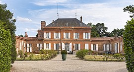 Chateau | |
 Coat of arms | |
Location of Lapeyrouse-Fossat .mw-parser-output .locmap .od{position:absolute}.mw-parser-output .locmap .id{position:absolute;line-height:0}.mw-parser-output .locmap .l0{font-size:0;position:absolute}.mw-parser-output .locmap .pv{line-height:110%;position:absolute;text-align:center}.mw-parser-output .locmap .pl{line-height:110%;position:absolute;top:-0.75em;text-align:right}.mw-parser-output .locmap .pr{line-height:110%;position:absolute;top:-0.75em;text-align:left}.mw-parser-output .locmap .pv>div{display:inline;padding:1px}.mw-parser-output .locmap .pl>div{display:inline;padding:1px;float:right}.mw-parser-output .locmap .pr>div{display:inline;padding:1px;float:left}html.skin-theme-clientpref-night .mw-parser-output .od,html.skin-theme-clientpref-night .mw-parser-output .od .pv>div,html.skin-theme-clientpref-night .mw-parser-output .od .pl>div,html.skin-theme-clientpref-night .mw-parser-output .od .pr>div{background:#000;color:#fff}html.skin-theme-clientpref-night .mw-parser-output .locmap{filter:grayscale(0.6)}@media(prefers-color-scheme:dark){html.skin-theme-clientpref-os .mw-parser-output .locmap{filter:grayscale(0.6)}html.skin-theme-clientpref-os .mw-parser-output .od,html.skin-theme-clientpref-os .mw-parser-output .od .pv>div,html.skin-theme-clientpref-os .mw-parser-output .od .pl>div,html.skin-theme-clientpref-os .mw-parser-output .od .pr>div{background:#000;color:#fff}}  Lapeyrouse-Fossat  Lapeyrouse-Fossat | |
| Coordinates: 43°41′34″N 1°31′02″E / 43.6928°N 1.5172°E | |
| Country | France |
| Region | Occitania |
| Department | Haute-Garonne |
| Arrondissement | Toulouse |
| Canton | Pechbonnieu |
| Intercommunality | Coteaux du Girou |
| Government | |
| • Mayor (2020–2026) | Corinne Gonzalez[1] |
| Area 1 | 9.49 km2 (3.66 sq mi) |
| Population (2021)[2] | 2,947 |
| • Density | 310/km2 (800/sq mi) |
| Time zone | UTC+01:00 (CET) |
| • Summer (DST) | UTC+02:00 (CEST) |
| INSEE/Postal code | 31273 /31180 |
| Elevation | 132–215 m (433–705 ft) (avg. 195 m or 640 ft) |
| 1 French Land Register data, which excludes lakes, ponds, glaciers > 1 km2 (0.386 sq mi or 247 acres) and river estuaries. | |
Population edit
The inhabitants of the commune are known as Lapeyrousiens and Lapeyrousiennes in French.
| Year | Pop. | ±% p.a. |
|---|---|---|
| 1968 | 607 | — |
| 1975 | 894 | +5.69% |
| 1982 | 1,295 | +5.44% |
| 1990 | 1,596 | +2.65% |
| 1999 | 2,056 | +2.85% |
| 2007 | 2,555 | +2.75% |
| 2012 | 2,768 | +1.61% |
| 2017 | 2,821 | +0.38% |
| 2019 | 2,886 | +1.15% |
| Source: INSEE[3] | ||
See also edit
References edit
- ^ "Répertoire national des élus: les maires" (in French). data.gouv.fr, Plateforme ouverte des données publiques françaises. 13 September 2022.
- ^ "Populations légales 2021". The National Institute of Statistics and Economic Studies. 28 December 2023.
- ^ Population en historique depuis 1968, INSEE
Wikimedia Commons has media related to Lapeyrouse-Fossat.