
KNOWPIA
WELCOME TO KNOWPIA

Larmor-Plage 
Summary
Larmor-Plage (French pronunciation: [laʁmɔʁ plaʒ]; Breton: An Arvor) is a commune in the Morbihan department of Brittany in north-western France.[3]
Larmor-Plage
An Arvor | |
|---|---|
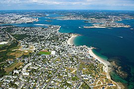 Larmor-Plage and the Blavet river | |
 Coat of arms | |
Location of Larmor-Plage .mw-parser-output .locmap .od{position:absolute}.mw-parser-output .locmap .id{position:absolute;line-height:0}.mw-parser-output .locmap .l0{font-size:0;position:absolute}.mw-parser-output .locmap .pv{line-height:110%;position:absolute;text-align:center}.mw-parser-output .locmap .pl{line-height:110%;position:absolute;top:-0.75em;text-align:right}.mw-parser-output .locmap .pr{line-height:110%;position:absolute;top:-0.75em;text-align:left}.mw-parser-output .locmap .pv>div{display:inline;padding:1px}.mw-parser-output .locmap .pl>div{display:inline;padding:1px;float:right}.mw-parser-output .locmap .pr>div{display:inline;padding:1px;float:left}html.skin-theme-clientpref-night .mw-parser-output .od,html.skin-theme-clientpref-night .mw-parser-output .od .pv>div,html.skin-theme-clientpref-night .mw-parser-output .od .pl>div,html.skin-theme-clientpref-night .mw-parser-output .od .pr>div{background:#000;color:#fff}html.skin-theme-clientpref-night .mw-parser-output .locmap{filter:grayscale(0.6)}@media(prefers-color-scheme:dark){html.skin-theme-clientpref-os .mw-parser-output .locmap{filter:grayscale(0.6)}html.skin-theme-clientpref-os .mw-parser-output .od,html.skin-theme-clientpref-os .mw-parser-output .od .pv>div,html.skin-theme-clientpref-os .mw-parser-output .od .pl>div,html.skin-theme-clientpref-os .mw-parser-output .od .pr>div{background:#000;color:#fff}}  Larmor-Plage  Larmor-Plage | |
| Coordinates: 47°42′26″N 3°22′59″W / 47.7072°N 3.3831°W | |
| Country | France |
| Region | Brittany |
| Department | Morbihan |
| Arrondissement | Lorient |
| Canton | Ploemeur |
| Intercommunality | Lorient Agglomération |
| Government | |
| • Mayor (2020–2026) | Patrice Valton[1] |
| Area 1 | 7.27 km2 (2.81 sq mi) |
| Population (2021)[2] | 8,318 |
| • Density | 1,100/km2 (3,000/sq mi) |
| Time zone | UTC+01:00 (CET) |
| • Summer (DST) | UTC+02:00 (CEST) |
| INSEE/Postal code | 56107 /56260 |
| Elevation | 0–39 m (0–128 ft) |
| 1 French Land Register data, which excludes lakes, ponds, glaciers > 1 km2 (0.386 sq mi or 247 acres) and river estuaries. | |
History edit
Larmor-Plage was created as a new commune in 1925. Before that, it came within the administrative area of the town of Ploemeur. It was almost completely destroyed in World War II.
Larmor-Plage is twinned with the town of Youghal in County Cork, Ireland.
Population edit
| Year | Pop. | ±% p.a. |
|---|---|---|
| 1968 | 5,877 | — |
| 1975 | 5,389 | −1.23% |
| 1982 | 6,373 | +2.42% |
| 1990 | 8,078 | +3.01% |
| 1999 | 8,470 | +0.53% |
| 2007 | 8,415 | −0.08% |
| 2012 | 8,219 | −0.47% |
| 2017 | 8,299 | +0.19% |
| Source: INSEE[4] | ||
Sights edit
The church Notre-Dame-de-Larmor is located in the centre of the town. It was built in the fifteenth century.
Environment edit
Kerguelen is a natural park.
Sports edit
Windsurfing is an important activity. The nautical centre of Kerguelen is the first school of sailing in France.
See also edit
References edit
- ^ "Maires du Morbihan" (PDF). Préfecture du Morbihan. 7 July 2020.
- ^ "Populations légales 2021". The National Institute of Statistics and Economic Studies. 28 December 2023.
- ^ INSEE commune file
- ^ Population en historique depuis 1968, INSEE
External links edit
Wikimedia Commons has media related to Larmor-Plage.
- Official site (in French)
- Base Mérimée: Search for heritage in the commune, Ministère français de la Culture. (in French)
- Mayors of Morbihan Association (in French)