


Summary
Larrazet (French pronunciation: [laʁazɛ]; Occitan: L'Arraset) is a commune in the Tarn-et-Garonne department in the Occitanie region in southern France. The village has bastide character, with its old half-timbered houses and wooden frames, its narrow streets, its remains of ramparts and the arch of the old gate of the barbican.[3]
Larrazet | |
|---|---|
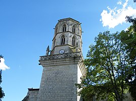 The church of Sainte-Marie-Madeleine, in Larrazet | |
 Coat of arms | |
Location of Larrazet .mw-parser-output .locmap .od{position:absolute}.mw-parser-output .locmap .id{position:absolute;line-height:0}.mw-parser-output .locmap .l0{font-size:0;position:absolute}.mw-parser-output .locmap .pv{line-height:110%;position:absolute;text-align:center}.mw-parser-output .locmap .pl{line-height:110%;position:absolute;top:-0.75em;text-align:right}.mw-parser-output .locmap .pr{line-height:110%;position:absolute;top:-0.75em;text-align:left}.mw-parser-output .locmap .pv>div{display:inline;padding:1px}.mw-parser-output .locmap .pl>div{display:inline;padding:1px;float:right}.mw-parser-output .locmap .pr>div{display:inline;padding:1px;float:left}html.skin-theme-clientpref-night .mw-parser-output .od,html.skin-theme-clientpref-night .mw-parser-output .od .pv>div,html.skin-theme-clientpref-night .mw-parser-output .od .pl>div,html.skin-theme-clientpref-night .mw-parser-output .od .pr>div{background:#000;color:#fff}html.skin-theme-clientpref-night .mw-parser-output .locmap{filter:grayscale(0.6)}@media(prefers-color-scheme:dark){html.skin-theme-clientpref-os .mw-parser-output .locmap{filter:grayscale(0.6)}html.skin-theme-clientpref-os .mw-parser-output .od,html.skin-theme-clientpref-os .mw-parser-output .od .pv>div,html.skin-theme-clientpref-os .mw-parser-output .od .pl>div,html.skin-theme-clientpref-os .mw-parser-output .od .pr>div{background:#000;color:#fff}}  Larrazet  Larrazet | |
| Coordinates: 43°55′55″N 1°05′00″E / 43.9319°N 1.0833°E | |
| Country | France |
| Region | Occitania |
| Department | Tarn-et-Garonne |
| Arrondissement | Castelsarrasin |
| Canton | Beaumont-de-Lomagne |
| Intercommunality | Lomagne Tarn-et-Garonnaise |
| Government | |
| • Mayor (2020–2026) | Jean-Louis Coureau[1] |
| Area 1 | 14.91 km2 (5.76 sq mi) |
| Population (2021)[2] | 694 |
| • Density | 47/km2 (120/sq mi) |
| Time zone | UTC+01:00 (CET) |
| • Summer (DST) | UTC+02:00 (CEST) |
| INSEE/Postal code | 82093 /82500 |
| Elevation | 85–187 m (279–614 ft) (avg. 81 m or 266 ft) |
| 1 French Land Register data, which excludes lakes, ponds, glaciers > 1 km2 (0.386 sq mi or 247 acres) and river estuaries. | |
In the 17th century, Johan de Cardailhac, abbot of Belleperche Abbey, ordered the construction of a church, flanked by a majestic hexagonal bell tower, as well as a massive stone bridge which today no longer exists. The Eglise Sainte Marie-Madeleine, the church of Larrazet has a single nave, with a square sanctuary. It is built entirely of ashlar from local quarries. Theis stems from the need to use churches as a place of refuge during the French Wars of Religion; it was necessary to remove sills and ledges, which would have provided a somewhat daring assailant with climbing facilities. Above the entrance door is a broken statue, which was to represent the Virgin holding the child Jesus. At the base one can make out flamboyant patterns.[4]
See also edit
References edit
- ^ "Répertoire national des élus: les maires" (in French). data.gouv.fr, Plateforme ouverte des données publiques françaises. 13 September 2022.
- ^ "Populations légales 2021". The National Institute of Statistics and Economic Studies. 28 December 2023.
- ^ "Le village Larrazet en Tarn-et-Garonne". www.larrazet.fr. nd. Retrieved 2023-04-21.
- ^ "L'Eglise Sainte Marie-Madeleine et son clocher". www.larrazet.fr Larrazet en Tarn-et-Garonne (82) le site officiel de la commune. n.d. Retrieved 2023-04-21.
External links edit
- Larrazet home page