


Summary
The Las Conchas Fire was a large wildfire in the state of New Mexico, in the United States, in 2011. The fire started in Santa Fe National Forest and burned more than 150,000 acres, threatening Los Alamos National Laboratory and the town of Los Alamos. After five days of burning, it became the largest wildfire in New Mexico state history at the time.[4][dead link] It was surpassed in 2012 by the much larger Whitewater-Baldy Complex Fire and in 2022 by the Calf Canyon/Hermits Peak Fire and the Black Fire[5] making the Las Conchas Fire the fourth-largest fire in New Mexico's recorded history.[6]
| Las Conchas Fire | |
|---|---|
 From Española, New Mexico, June 29, 2011 | |
| Date(s) | June 26, 2011 1:00 pm (MDT) |
| Location | New Mexico |
| Coordinates | 35°48′11″N 106°26′24″W / 35.803°N 106.440°W |
| Statistics | |
| Burned area | 156,293 acres,[1][dead link] 244 sq mi (630 km2) |
| Impacts | |
| Deaths | 0 |
| Non-fatal injuries | 15[1] |
| Structures destroyed | 63 residences, 49 outbuildings[2] |
| Ignition | |
| Cause | Power line[3] |
| Map | |
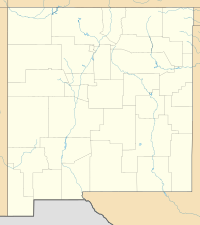  | |

Progression edit
The fire started on June 26, 2011, at approximately 1:00 pm Mountain Daylight Time[2] at 35°49′39.47″N 106°28′36.12″W / 35.8276306°N 106.4767000°W when a gust of wind blew a severely rotted 75 foot (23 m) aspen tree on private property into a power line on a Jemez Electric Cooperative easement. The ignition point remained largely unburned, with the fire jumping to the canopy farther downwind.[7][3][8] Usually, wildfires don't spread downward. Instead, they tend to move upward, drying out and igniting fresh vegetation above where they started. This upward movement is a common behavior, as the fire climbs vertically, affecting the surrounding area in an upward direction.[9] However, on the first day, driven by strong and unpredictable winds, the fire burned 43,000 acres in the Jemez Mountains, near the Pajarito Plateau[10][11][12]—a rate of about an acre per second.[13]
As per local fire officials, by the evening of the initial day of the wildfire, none of it had been brought under control, leading to a voluntary evacuation order for the county.[14] The fire burned over 61,000 acres by the end of the day on June 27,[10] pushed north by winds into the Pajarito Mountain Ski Area. The fire also burned south, threatening the town of Cochiti, New Mexico.[15] On June 28, this estimate was increased to nearly 61,000 acres.[16] On June 29, it was reported that the fire was 3 percent contained, 12 miles southwest of Los Alamos, and had burned nearly 70,000 acres (109 sq mi).[17] By then the fire had pushed farther north into the land owned and held sacred by Santa Clara Pueblo.
By June 30, the burned area had increased to over 103,000 acres (161 sq mi), making it the largest fire in New Mexico history (the previous largest was the 2003 Dry Lakes Fire, which burned over 94,000 acres).[4]
Mandatory evacuation orders were issued for Los Alamos on June 27,[18] and Los Alamos National Laboratory was closed to all non-essential personnel.[19][20] The evacuation order was lifted on July 3, at which time Los Alamos residents were allowed to return to their homes.[21] The Los Alamos National Laboratory re-opened on July 6.[22] As of July 14, 2011, the fire was 57% contained.[2]
On June 27, a one-acre spot fire burned on Los Alamos National Laboratory until firefighters extinguished it. Authorities reported that the fire did not threaten essential buildings. That was the only time the fire burned on lab property, as the fire then moved away.[23][24]
The fire was 100% contained on August 3 with efforts for recovery of the burned areas beginning shortly after.[1] The Las Conchas Fire burned 156,000 acres in the end, much of it at high severity.
What occurs after edit
After a wildfire, the landscape of the scorched forest undergoes significant transformation. The aftermath reveals a varied scene, with some trees completely consumed by the fire while other areas experience only light burning. Although certain animals may have evacuated, they discover new sheltering opportunities, with certain bird and insect species flourishing in the charred remains of dead trees. Furthermore, fires contribute to soil rejuvenation by introducing new growth and nutrients. The openness of heavily burned regions facilitates predator hunting, and sapling trees flourish in these exposed spaces. The regrowth of a forest post-fire initiates swiftly, underscoring the resilience of ecosystems. [25] Landscape alterations, often enduring for extended periods, result from wildfires intensified by heat and drought. [26]
Factors of what causes wildfires edit
Animals significantly impact wildfire dynamics. Grazing animals like goats and cattle help manage fire in grassy areas by clearing vegetation, reducing available fuel, and minimizing the risk of extensive fires. [27] A significant factor contributing to wildfires is human activities. Unattended campfires, discarded cigarette butts, and equipment sparks can ignite dry vegetation. Additionally, activities such as arson or burning debris without proper precautions can lead to uncontrolled wildfires. [28] Weather can also play a crucial role in wildfire occurrences. Prolonged periods of drought, combined with high temperatures and low humidity, create ideal conditions for vegetation to dry out, becoming highly flammable. Strong winds can then carry embers over long distances, sparking new fires and causing existing ones to spread rapidly.[29] Natural factors, such as lightning, can also trigger wildfires. When lightning strikes dry vegetation, it can ignite a fire that may go unnoticed initially. Given the right weather conditions, these fires can escalate and become significant wildfires, especially in areas prone to thunderstorms with little accompanying rainfall.[30]
Impact edit
Archeological sites edit
The Pajarito Plateau is rich in prehistoric Puebloan archeological sites. A study after the fire confirmed 1,104 of the sites were directly in the burn zone. Damage to sites from high-intensity fire includes spalling of stone structures, coating with soot and wax, and heat-induced cracking of stone and ceramic artifacts.[31]
Flooding edit
Destructive flooding occurred in the burned region as the result of heavy monsoon rainstorms on August 21. The flooding was exacerbated by devegetated land and charred soil covered with waxy burn products, making the land in the burn scar hydrophobic.[13][32]
Santa Clara Pueblo edit
Sixteen thousand acres of Santa Clara Pueblo land burned in the fire, much of it in the pueblo's watershed. Forty-five percent of the watershed was burned, leading to fears of flooding. The pueblo responded by preparing for floods.[33] As much of the burned area is still as of 2022 at risk for dangerous flash floods, the pueblo installed three large steel and concrete debris racks on Santa Clara Creek upstream from the pueblo.[1] Videos exist on Youtube.com showing flash flooding and debris flows in the pueblo in the years after the fire.[34]
Bandelier National Monument edit
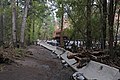
In Frijoles Canyon, National Park Service workers piled sandbags and used jersey barriers in a successful effort to protect the historic visitor center at Bandelier National Monument and other structures and cultural assets from flooding along El Rito de los Frijoles. Although the efforts did indeed save structures and assets from damage, widespread damage occurred in the watershed, including to trails, buildings, and archeological sites.[35]
-
 Flood damage below Long House, Bandelier National Monument
 -
 Flood damage at the visitor center, Bandelier National Monument
 -
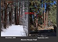 Flood damage along the Alcove House Trail, Bandelier National Monument
 -
 Flood damage on El Rito de los Frijoles, Bandelier National Monument


Dixon's Apple Orchard edit
A popular tradition in New Mexico was the fall harvest at Dixon's Apple Orchard, a family-owned orchard in Cochiti Canyon near Cochiti, New Mexico, established in 1944 from grafts from a wild apple tree found growing nearby. Earlier in the year, a late frost had damaged some of the approximately 3,000 New Mexico desert apple trees.[36] On the first day of the fire, the flames reached the canyon walls that surround the orchard. The owners home, some of the equipment, and about 300 apple trees were destroyed by the flames. Efforts to subdue the fire on the property is cited with saving thousands of these trees.[37][36] However, on August 22, following the heavy monsoon rains, a massive flood laden with ash, boulders, and woodland debris swept through the canyon nearly two hours after rain clouds appeared over the mountains. The flood waters turned the small Rio Chiquito into a torrent "as wide as a football field" sufficient to cover the canyon from one wall to the other, damaging trees that had survived the fire, and covering the orchard in several feet (over a meter) of sediment.[37] The next day, while cleaning up and working to repair the orchard, a second flood hit the canyon, covering the orchard in a depth of over 12 feet (3.7 metres) of blackened water. Video exits on Youtube.com showing the destructive flooding.[38]
In January 2016, the land the orchard occupied was returned to Cochiti Pueblo in a land swap agreement. The ruins of the ancestral home, Old Cochiti Pueblo, overlooks the canyon immediately above the orchard; the Pueblo holds these lands as sacred. Remnants of the orchard, including several hundred apple trees, still stand in the canyon.[39]
Rio Grande edit
The burn scar lies directly in the watershed of the Rio Grande, the most important watersource in this region of the Southwest. Since the Rio Grande is a large watercourse, and the affected watersheds lie immediately upstream from Cochiti Dam, which manages flood control in the middle Rio Grande Valley, fears of flooding on the river were minimal. However, as ash and debris were swept into the river following the August floods, water quality was of concern, since the waters from Cochiti Reservoir are used from the dam down to Socorro for irrigation and drinking water, including agricultural use and domestic supply in Albuquerque, New Mexico's largest city; its capital of Santa Fe, as well as several Pueblos and other communities.[39]
Liability edit
As the tree that started the fire was on private property, but fell onto a utility easement, New Mexico State Environment Department investigated the ignition point and identified the igniter tree as an aspen on private property. The Jemez Electric Cooperitive, which owns and operates the lines, argued the tree was on private property and therefore had no authority to cut it down, having trimmed all trees within the easement in the previous two summers. The Coop blamed the Forest Service for not clearing the tree. The Forest Service argued that inspecting every tree along its borders was unrealistic, and pointed out language in the easement contract that requires the Coop to clear snags that lean toward its easements.[7]
Jurors in the Sandoval County court found the liability to be 75% to the Jemez Electric Cooperative, which owns and operates the powerline, 20% to the Tri-State Generation and Transmission Inc., which generates the electric energy which started the fire, and 5% to the U.S. Forest Service, as the tree was on private property managed by the service.[40]
The Forest Service billed the Coop $38 million for the cost of starting the fire, including supplies and equipment, firefighter wages, initial remediation, damages, and lost recreational income. Two Pueblos also filed for compensation against the Coop, in addition to seeking compensation from the Forest Service, who granted the Coop the utility easement.[41]
See also edit
- 1954 Water Canyon Fire
- 1977 La Mesa Fire
- 1996 Dome Fire
- 1998 Oso Complex Fire
- 2000 Cerro Grande Fire
References edit
- ^ a b c d "Las Conchas Wildfire". Incident Information System. Archived from the original on October 16, 2011. Retrieved August 14, 2011.
- ^ a b c "Las Conchas Wildfire". Incident Information System. Archived from the original on October 16, 2011. Retrieved July 14, 2011.
- ^ a b "Investigators determine cause of Las Conchas Fire". New Mexico Fire Information. July 3, 2011. Archived from the original on July 15, 2011. Retrieved July 5, 2011.
- ^ a b Sharpe, Magdalena; Pabst, Charlie (June 30, 2011). "The Las Conchas fire becomes the largest wildfire in state history". KOB. Retrieved June 30, 2011.
- ^ Romero, Leah. "Black Fire officially third largest wildfire in New Mexico history". Silver City Sun-News. Retrieved May 26, 2022.
- ^ "Whitewater-Baldy Complex fire now biggest ever in New Mexico". KOB. May 30, 2012. Archived from the original on June 1, 2012. Retrieved May 30, 2012.
- ^ a b Kasper, Andrew (September 1, 2011). "Is Co-op to Blame for Las Conchas Fire?". Rio Grande Sun. Retrieved January 18, 2022.
- ^ "Las Conchas Fact Sheet" (PDF). United States National Park Service. Retrieved January 17, 2022.
- ^ "Pillar Of Fire". www.magzter.com. Retrieved November 13, 2023.
- ^ a b "Las Conchas Fire NM-N6S-0000451 Map". Incident Information System. Retrieved August 27, 2011.
- ^ "Las Conchas wildfire at 3500+ acres; County under voluntary evacuation; Lab to be closed Monday – photos added". LAMonitor.com. Retrieved June 27, 2011.
- ^ "3,500-acre Jemez blaze brings back memories of Cerro Grande". The Santa Fe New Mexican. Retrieved June 27, 2011.
- ^ a b "The Las Conchas Fire". U.S. Department of the Interior, National Park Service. Retrieved June 5, 2012.
- ^ "Fire Near Los Alamos Swells To 3,500 Acres". KOAT news. Retrieved June 27, 2011.
- ^ Sharpe, Magdalena (June 27, 2011). "Los Conchas fire spreads to over 43,000 acres". KOB. Archived from the original on July 1, 2011. Retrieved June 27, 2011.
- ^ Flores, Danielle; Sharpe, Magdelena (June 28, 2011). "Las Conchas blaze grows close to 61,000 acres". KOB. Retrieved June 28, 2011.
- ^ The Associated Press (June 29, 2011). "Massive Las Conchas blaze is 3% contained". KOB. Retrieved June 29, 2011.
- ^ "MANDATORY Evacuations for Los Alamos". NM Fire Info. Retrieved June 27, 2011.
- ^ "Wildfire triggers evacuation for Los Alamos lab". Reuters Africa. Archived from the original on June 30, 2011. Retrieved June 27, 2011.
- ^ Mack, Erik. "Wildfire closes Los Alamos National Laboratory". CNET. Retrieved June 27, 2011.
- ^ "The Associated Press: Los Alamos evacuation order lifted; 12,000 go home". www.google.com. Archived from the original on July 4, 2011.
- ^ "Service Unavailable".
- ^ "Las Conchas wildfire at 43,000+ acres; Los Alamos under mandatory evacuation – photos added". Los Alamos Monitor. June 27, 2011. Retrieved June 27, 2011.
- ^ Rushe, Dominic (June 28, 2011). "Wildfire reaches Los Alamos nuclear facility". The Guardian. Retrieved June 27, 2011.
- ^ "Abdo Digital - The World's Wildfires". abdodigital.com. Retrieved December 13, 2023.
- ^ "Climate Change: An Encyclopedia of Science, Society, and Solutions [3 volumes]". publisher.abc-clio.com. Retrieved December 13, 2023.
- ^ "Abdo Digital - The World's Wildfires". abdodigital.com. Retrieved December 13, 2023.
- ^ https://eartheclipse.com/environment/various-causes-and-effects-of-wildfires.html
- ^ https://eartheclipse.com/environment/various-causes-and-effects-of-wildfires.html
- ^ https://eartheclipse.com/environment/various-causes-and-effects-of-wildfires.html
- ^ "Bandelier's Archeological Sites and the Las Conchas Fire" (PDF). United States National Park Service. Retrieved January 18, 2022.
- ^ Matlock, Staci (August 22, 2011). "Flooding tests preparation in Santa Fe, Las Conchas burn scar area". Santa Fe New Mexican. Retrieved June 5, 2012.
- ^ "Pueblo Needs Help, Prepares for Rain". KRQE. July 9, 2011. Retrieved July 9, 2011.
- ^ "# 1 Santa Clara Creek Flash Flooding - 21 Aug 2011 - First Water Run Off". Youtube. Retrieved January 18, 2022.
- ^ "NPS.govPark HomeLearn About the ParkNatureWildland Fire2011 Las Conchas Fire The Las Conchas Fire". Bandelier National Monument. United States National Park Service. Retrieved January 18, 2022.
- ^ a b "Dixon Apple Orchard Survives Fire". Albuquerque Journal. June 28, 2011. Retrieved January 18, 2022.
- ^ a b "Dixon Apple Farm Charred By Fire". KOAT Albuquerque. July 5, 2011. Retrieved January 18, 2022.
- ^ "Cochiti Canyon Flash Flood". Youtube.com. New Mexico EPSCoR. Retrieved January 18, 2022.
- ^ a b "Dixon's Apple Orchard to return to Cochiti Pueblo in land swap". Santa Fe New Mexican. January 13, 2016. Retrieved January 18, 2022.
- ^ "Jury: Utilities 95% to blame for Las Conchas Fire". Santa Fe New Mexican. Associated Press. October 28, 2015. Retrieved January 18, 2022.
- ^ Gabbard, Bill. "USFS bills power company $38 million for starting Las Conchas Fire". No. November 8, 2013. Wildfire Today. Retrieved January 18, 2022.
External links edit
- Las Conchas Fire Archived October 16, 2011, at the Wayback Machine, InciWeb Incident Information System
- Las Conchas Fire, New Mexico Fire Information