


Summary
Las Piedras (Spanish pronunciation: [las ˈpjeðɾas]), is a town and municipality in east Puerto Rico located in the central eastern region of the island, north of Yabucoa; south of Canóvanas and Río Grande; east of Juncos and San Lorenzo; and west of Naguabo and Humacao. Las Piedras is spread over 7 barrios and Las Piedras Pueblo (the downtown area and the administrative center of the city). It is part of the San Juan-Caguas-Guaynabo Metropolitan Statistical Area.
Las Piedras
Municipio de Las Piedras | |
|---|---|
Town and Municipality | |
 View from Collores, Las Piedras | |
 Flag 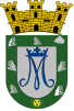 Coat of arms | |
| Nickname: "La Ciudad de los Artesanos" | |
| Anthem: "Somos de la Ribera" | |
 Map of Puerto Rico highlighting Las Piedras Municipality | |
| Coordinates: 18°10′59″N 65°51′59″W / 18.18306°N 65.86639°W | |
| Sovereign state | |
| Commonwealth | |
| Founded | 1793 |
| Barrios | |
| Government | |
| • Mayor | Miguel "Micky" López (PNP) |
| • Senatorial dist. | 7 - Humacao |
| • Representative dist. | 35 |
| Area | |
| • Total | 33.89 sq mi (87.8 km2) |
| • Land | 33.88 sq mi (87.7 km2) |
| • Water | .01 sq mi (0.03 km2) |
| Population (2020)[1] | |
| • Total | 40,180 |
| • Rank | 33rd in Puerto Rico |
| • Density | 1,200/sq mi (460/km2) |
| Demonym | Pedreños |
| Time zone | UTC-4 (AST) |
| ZIP Code | 00771 |
| Area code | 787/939 |
| Major routes | |
Las Piedras has many natural attractions such as Cueva del Indio which contains original Taino caves and paintings that denote some characteristics of the island's natives. Las Piedras is located about 45 minutes from San Juan, Puerto Rico's capital and 5 minutes from Palmas del Mar, Humacao which is one of the biggest resorts in the Caribbean.
El Toro, the highest point in the Sierra de Luquillo, is located in the boundary between the municipalities of Las Piedras and Río Grande.
History edit
Las Piedras was founded in 1793.
Puerto Rico was ceded by Spain in the aftermath of the Spanish–American War under the terms of the Treaty of Paris of 1898 and became a territory of the United States. In 1899, the United States Department of War conducted a census of Puerto Rico finding that the population of Las Piedras was 8,602.[2]
On September 20, 2017 Hurricane Maria struck Puerto Rico. In Las Piedras, 500 residences lost their roof.[3] The hurricane triggered numerous landslides in Las Piedras with 205 mph winds and significant rainfall.[4][5] Infrastructure in Las Piedras was heavily damaged and most regions were inaccessible immediately following the hurricane.[6]
Geography edit
Las Piedras is on the eastern side of Puerto Rico but not on the coast. According to the 2010 U.S. Census Bureau, the municipality has a total area of 33.89 square miles (87.8 km2), of which 33.88 square miles (87.7 km2) is land and .01 square miles (0.026 km2) is water.[7]
Barrios edit
Like all municipalities of Puerto Rico, Las Piedras is subdivided into barrios. The municipal buildings, central square and large Catholic church are located near the center of the municipality, in a small barrio referred to as "el pueblo".[8][9][10][11]
Sectors edit
Barrios (which are like minor civil divisions)[12] and subbarrios,[13] are further subdivided into smaller areas called sectores (sectors in English). The types of sectores may vary, from normally sector to urbanización to reparto to barriada to residencial, among others.[14][15][16]
Special Communities edit
Comunidades Especiales de Puerto Rico (Special Communities of Puerto Rico) are marginalized communities whose citizens are experiencing a certain amount of social exclusion. A map shows these communities occur in nearly every municipality of the commonwealth. Of the 742 places that were on the list in 2014, the following barrios, communities, sectors, or neighborhoods were in Las Piedras: Quebrada Grande neighborhood, Rivera neighborhood (Hoyo Gardens), Boquerón, Cinco Cuerdas, El Cerrito, Fondo del Saco, Lijas and Pueblito del Río.[17][18]
Demographics edit
| Census | Pop. | Note | %± |
|---|---|---|---|
| 1900 | 8,602 | — | |
| 1920 | 10,620 | — | |
| 1930 | 12,907 | 21.5% | |
| 1940 | 15,389 | 19.2% | |
| 1950 | 16,208 | 5.3% | |
| 1960 | 17,047 | 5.2% | |
| 1970 | 18,112 | 6.2% | |
| 1980 | 22,412 | 23.7% | |
| 1990 | 27,896 | 24.5% | |
| 2000 | 34,485 | 23.6% | |
| 2010 | 38,675 | 12.2% | |
| 2020 | 35,180 | −9.0% | |
| U.S. Decennial Census[19] 1899 (shown as 1900)[20] 1910-1930[21] 1930-1950[22] 1960-2000[23] 2010[10] 2020[24] | |||
Tourism edit
Landmarks and places of interest edit
- La Cueva del Indio
- Monte del Retiro
- Artesanial Walk
- Francisco Negrón Park
- Las Piedras Historic Museum
- Panoramic Route 917
Economy edit
Industry edit
- Manufacturing: computers and pharmaceutical.
Culture edit
Festivals and events edit
Las Piedras celebrates its patron saint festival in December. The Fiestas Patronales Nuestra Señora de Asunción is a religious and cultural celebration that generally features parades, games, artisans, amusement rides, regional food, and live entertainment.[7]
Other festivals and events celebrated in Las Piedras include:
Government edit
Like all municipalities in Puerto Rico, Las Piedras is administered by a mayor. The current mayor is Mickey Lopez, from the New Progressive Party (PNP). Lopez was elected at the Puerto Rican general election, 2008 -present general election.
The city belongs to the Puerto Rico Senatorial district VII, which is represented by two senators. In 2012, Jorge Suárez and José Luis Dalmau were elected as District Senators.[27]
Transportation edit
There are 24 bridges in Las Piedras.[28]
Symbols edit
The municipio has an official flag and coat of arms.[29]
Flag edit
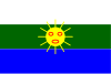
The flag of Las Piedras has three horizontal stripes of equal width, the stripe at the top is colored white, the center stripe is colored green and the bottom stripe is colored blue. In the middle of the flag rests an image of the Taíno sun in yellow.[30]
Coat of arms edit
In a silver field resides a blue monogram of the Holy Virgin, topped by a blue crown. Seven silver stones border the silver field and at the tip of the shield resides the Taíno sun in gold denominated as the "Sun of Las Piedras".[30]
Notable natives edit
- Juan Manuel Lebrón - Comedian
- Miguel Hernández Agosto - Puerto Rico Senate President (1988-1992).
- Nicky Cruz - evangelist, reformed gang leader, author of bestselling book, "Run Baby Run".
See also edit
- List of Puerto Ricans
- History of Puerto Rico
- Did you know-Puerto Rico?
References edit
- ^ Bureau, US Census. "PUERTO RICO: 2020 Census". The United States Census Bureau. Retrieved August 25, 2021.
- ^ Joseph Prentiss Sanger; Henry Gannett; Walter Francis Willcox (1900). Informe sobre el censo de Puerto Rico, 1899, United States. War Dept. Porto Rico Census Office (in Spanish). Imprenta del gobierno. p. 163. Archived from the original on November 15, 2012. Retrieved March 13, 2020.
- ^ "María, un nombre que no vamos a olvidar. El 90 por ciento de las comunidades en Las Piedras quedó incomunicado" [Maria, a name we won't forget. 90% of community of Las Piedras is isolated]. El Nuevo Día (in Spanish). June 13, 2019. Retrieved September 11, 2022.
- ^ "Preliminary Locations of Landslide Impacts from Hurricane Maria, Puerto Rico". USGS Landslide Hazards Program. USGS. Archived from the original on March 3, 2019. Retrieved March 3, 2019.
- ^ "Preliminary Locations of Landslide Impacts from Hurricane Maria, Puerto Rico" (PDF). USGS Landslide Hazards Program. USGS. Archived (PDF) from the original on March 3, 2019. Retrieved March 3, 2019.
- ^ "María, un nombre que no vamos a olvidar. El 90 por ciento de las comunidades en Las Piedras quedó incomunicado" [Maria, a name we will never forget. Up to 90% of Las Piedras communities were left incommunicado]. El Nuevo Día (in Spanish). June 13, 2019. Retrieved September 11, 2022.
- ^ a b "Las Piedras Municipality". enciclopediapr.org. Fundación Puertorriqueña de las Humanidades (FPH). Archived from the original on August 23, 2020. Retrieved March 20, 2019.
- ^ Picó, Rafael; Buitrago de Santiago, Zayda; Berrios, Hector H. Nueva geografía de Puerto Rico: física, económica, y social, por Rafael Picó. Con la colaboración de Zayda Buitrago de Santiago y Héctor H. Berrios. San Juan Editorial Universitaria, Universidad de Puerto Rico,1969. Archived from the original on December 26, 2018. Retrieved December 31, 2018.
- ^ Gwillim Law (May 20, 2015). Administrative Subdivisions of Countries: A Comprehensive World Reference, 1900 through 1998. McFarland. p. 300. ISBN 978-1-4766-0447-3. Retrieved December 25, 2018.
- ^ a b Puerto Rico:2010:population and housing unit counts.pdf (PDF). U.S. Dept. of Commerce Economics and Statistics Administration U.S. Census Bureau. 2010. Archived (PDF) from the original on February 20, 2017. Retrieved December 31, 2018.
- ^ "Map of Las Piedras at the Wayback Machine" (PDF). Archived from the original (PDF) on March 24, 2018. Retrieved December 29, 2018.
- ^ a b "US Census Barrio-Pueblo definition". factfinder.com. US Census. Archived from the original on May 13, 2017. Retrieved January 5, 2019.
- ^ "P.L. 94-171 VTD/SLD Reference Map (2010 Census): Las Piedras Municipio, PR" (PDF). www2.census.gov. U.S. DEPARTMENT OF COMMERCE Economics and Statistics Administration U.S. Census Bureau. Archived (PDF) from the original on August 23, 2020. Retrieved August 22, 2020.
- ^ "Agencia: Oficina del Coordinador General para el Financiamiento Socioeconómico y la Autogestión (Proposed 2016 Budget)". Puerto Rico Budgets (in Spanish). Archived from the original on June 28, 2019. Retrieved June 28, 2019.
- ^ Rivera Quintero, Marcia (2014), El vuelo de la esperanza: Proyecto de las Comunidades Especiales Puerto Rico, 1997-2004 (first ed.), San Juan, Puerto Rico Fundación Sila M. Calderón, ISBN 978-0-9820806-1-0
- ^ "Leyes del 2001". Lex Juris Puerto Rico (in Spanish). Archived from the original on September 14, 2018. Retrieved June 24, 2020.
- ^ Rivera Quintero, Marcia (2014), El vuelo de la esperanza: Proyecto de las Comunidades Especiales Puerto Rico, 1997-2004 (1st ed.), San Juan, Puerto Rico Fundación Sila M. Calderón, p. 273, ISBN 978-0-9820806-1-0
- ^ "Comunidades Especiales de Puerto Rico" (in Spanish). August 8, 2011. Archived from the original on June 24, 2019. Retrieved June 24, 2019.
- ^ "U.S. Decennial Census". United States Census Bureau. Archived from the original on February 13, 2020. Retrieved September 21, 2017.
- ^ "Report of the Census of Porto Rico 1899". War Department Office Director Census of Porto Rico. Archived from the original on July 16, 2017. Retrieved September 21, 2017.
- ^ "Table 3-Population of Municipalities: 1930 1920 and 1910" (PDF). United States Census Bureau. Archived (PDF) from the original on August 17, 2017. Retrieved September 21, 2017.
- ^ "Table 4-Area and Population of Municipalities Urban and Rural: 1930 to 1950" (PDF). United States Census Bureau. Archived (PDF) from the original on August 30, 2015. Retrieved September 21, 2014.
- ^ "Table 2 Population and Housing Units: 1960 to 2000" (PDF). United States Census Bureau. Archived (PDF) from the original on July 24, 2017. Retrieved September 21, 2017.
- ^ Bureau, US Census. "PUERTO RICO: 2020 Census". The United States Census Bureau. Retrieved August 25, 2021.
- ^ "Population and Housing Unit Estimates". United States Census Bureau. Archived from the original on December 27, 1996. Retrieved September 21, 2017.
- ^ "Puerto Rico Festivales, Eventos y Actividades en Puerto Rico". Puerto Rico Hoteles y Paradores (in Spanish). Archived from the original on February 26, 2020. Retrieved July 17, 2020.
- ^ Elecciones Generales 2012: Escrutinio General Archived 2013-01-15 at the Wayback Machine on CEEPUR
- ^ "Las Piedras Bridges". National Bridge Inventory Data. US Dept. of Transportation. Archived from the original on February 21, 2019. Retrieved February 20, 2019.
- ^ "Ley Núm. 70 de 2006 -Ley para disponer la oficialidad de la bandera y el escudo de los setenta y ocho (78) municipios". LexJuris de Puerto Rico (in Spanish). Retrieved June 15, 2021.
- ^ a b "LAS PIEDRAS". LexJuris (Leyes y Jurisprudencia) de Puerto Rico (in Spanish). February 19, 2020. Archived from the original on February 19, 2020. Retrieved September 17, 2020.
External links edit
- Las Piedras and its barrios, United States Census Bureau
- Puerto Rico Government Directory - Las Piedras
Further reading edit
- Mapa de municipios y barrios - Las Piedras - Memoria Núm. 28 (PDF). University of Puerto Rico: Estado Libre Asociado de Puerto Rico, Oficina del Gobernador, Junta de Planificacion, Santurce, Puerto Rico. 1952.