
KNOWPIA
WELCOME TO KNOWPIA

Latoue 
Summary
Latoue is a village and commune in the Haute-Garonne department in southwestern France. It is best known for the castle which dominates the village.
Latoue | |
|---|---|
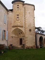 Chateau | |
Location of Latoue .mw-parser-output .locmap .od{position:absolute}.mw-parser-output .locmap .id{position:absolute;line-height:0}.mw-parser-output .locmap .l0{font-size:0;position:absolute}.mw-parser-output .locmap .pv{line-height:110%;position:absolute;text-align:center}.mw-parser-output .locmap .pl{line-height:110%;position:absolute;top:-0.75em;text-align:right}.mw-parser-output .locmap .pr{line-height:110%;position:absolute;top:-0.75em;text-align:left}.mw-parser-output .locmap .pv>div{display:inline;padding:1px}.mw-parser-output .locmap .pl>div{display:inline;padding:1px;float:right}.mw-parser-output .locmap .pr>div{display:inline;padding:1px;float:left}html.skin-theme-clientpref-night .mw-parser-output .od,html.skin-theme-clientpref-night .mw-parser-output .od .pv>div,html.skin-theme-clientpref-night .mw-parser-output .od .pl>div,html.skin-theme-clientpref-night .mw-parser-output .od .pr>div{background:#000;color:#fff}html.skin-theme-clientpref-night .mw-parser-output .locmap{filter:grayscale(0.6)}@media(prefers-color-scheme:dark){html.skin-theme-clientpref-os .mw-parser-output .locmap{filter:grayscale(0.6)}html.skin-theme-clientpref-os .mw-parser-output .od,html.skin-theme-clientpref-os .mw-parser-output .od .pv>div,html.skin-theme-clientpref-os .mw-parser-output .od .pl>div,html.skin-theme-clientpref-os .mw-parser-output .od .pr>div{background:#000;color:#fff}}  Latoue  Latoue | |
| Coordinates: 43°10′12″N 0°47′11″E / 43.17°N 0.7864°E | |
| Country | France |
| Region | Occitania |
| Department | Haute-Garonne |
| Arrondissement | Saint-Gaudens |
| Canton | Cazères |
| Intercommunality | CC Cœur et Coteaux du Comminges |
| Government | |
| • Mayor (2020–2026) | Pierre Bosc[1] |
| Area 1 | 17.62 km2 (6.80 sq mi) |
| Population (2021)[2] | 310 |
| • Density | 18/km2 (46/sq mi) |
| Time zone | UTC+01:00 (CET) |
| • Summer (DST) | UTC+02:00 (CEST) |
| INSEE/Postal code | 31278 /31800 |
| Elevation | 333–488 m (1,093–1,601 ft) (avg. 350 m or 1,150 ft) |
| 1 French Land Register data, which excludes lakes, ponds, glaciers > 1 km2 (0.386 sq mi or 247 acres) and river estuaries. | |
Population edit
| Year | Pop. | ±% |
|---|---|---|
| 1962 | 312 | — |
| 1968 | 379 | +21.5% |
| 1975 | 327 | −13.7% |
| 1982 | 323 | −1.2% |
| 1990 | 294 | −9.0% |
| 1999 | 284 | −3.4% |
| 2008 | 308 | +8.5% |
Sights edit
The Château de Latoue is a castle first built in the 12th century, with major additions and alterations in the 13th, 16th and 18th centuries. Privately owned, it has been listed in 1979 as a historic site by the French Ministry of Culture.[3]
See also edit
References edit
- ^ "Répertoire national des élus: les maires" (in French). data.gouv.fr, Plateforme ouverte des données publiques françaises. 13 September 2022.
- ^ "Populations légales 2021". The National Institute of Statistics and Economic Studies. 28 December 2023.
- ^ Base Mérimée: Château, Ministère français de la Culture. (in French)
Wikimedia Commons has media related to Latoue.