


Summary
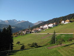
Laurein (German: [laʊˈraɪn]; Italian: Lauregno [lauˈreɲɲo]) is a comune (municipality) and a village in South Tyrol in northern Italy, located about 20 kilometres (12 mi) west of Bolzano.
Laurein | |
|---|---|
| Gemeinde Laurein Comune di Lauregno | |
 Laurein | |
Location of Laurein .mw-parser-output .locmap .od{position:absolute}.mw-parser-output .locmap .id{position:absolute;line-height:0}.mw-parser-output .locmap .l0{font-size:0;position:absolute}.mw-parser-output .locmap .pv{line-height:110%;position:absolute;text-align:center}.mw-parser-output .locmap .pl{line-height:110%;position:absolute;top:-0.75em;text-align:right}.mw-parser-output .locmap .pr{line-height:110%;position:absolute;top:-0.75em;text-align:left}.mw-parser-output .locmap .pv>div{display:inline;padding:1px}.mw-parser-output .locmap .pl>div{display:inline;padding:1px;float:right}.mw-parser-output .locmap .pr>div{display:inline;padding:1px;float:left}html.skin-theme-clientpref-night .mw-parser-output .od,html.skin-theme-clientpref-night .mw-parser-output .od .pv>div,html.skin-theme-clientpref-night .mw-parser-output .od .pl>div,html.skin-theme-clientpref-night .mw-parser-output .od .pr>div{background:#000;color:#fff}html.skin-theme-clientpref-night .mw-parser-output .locmap{filter:grayscale(0.6)}@media(prefers-color-scheme:dark){html.skin-theme-clientpref-os .mw-parser-output .locmap{filter:grayscale(0.6)}html.skin-theme-clientpref-os .mw-parser-output .od,html.skin-theme-clientpref-os .mw-parser-output .od .pv>div,html.skin-theme-clientpref-os .mw-parser-output .od .pl>div,html.skin-theme-clientpref-os .mw-parser-output .od .pr>div{background:#000;color:#fff}}  Laurein Location of Laurein in Italy  Laurein Laurein (Trentino-Alto Adige/Südtirol) | |
| Coordinates: 46°27′N 11°4′E / 46.450°N 11.067°E | |
| Country | Italy |
| Region | Trentino-Alto Adige/Südtirol |
| Province | South Tyrol (BZ) |
| Government | |
| • Mayor | Hartmann Thaler (SVP) |
| Area | |
| • Total | 14 km2 (5 sq mi) |
| Population (Nov. 2010)[2] | |
| • Total | 346 |
| • Density | 25/km2 (64/sq mi) |
| Demonym(s) | German:Laureiner Italian: lauregnesi |
| Time zone | UTC+1 (CET) |
| • Summer (DST) | UTC+2 (CEST) |
| Postal code | 39040 |
| Dialing code | 0436 |
| Website | Official website |
Geography edit
As of 30 November 2010, it had a population of 346 and an area of 14.2 square kilometres (5.5 sq mi).[3]
Laurein borders the following municipalities: Brez, Cagnò, Castelfondo, Cloz, Proveis, Revò, St. Pankraz and Ulten.
History edit
Coat-of-arms edit
The emblem represents a sable plough on or square, with the sides curved and the corners decorated with shamrock on azure. The plough symbolizes the reclamation of the fields and their processing; the four vertices represent the four original German-speaking municipalities of Non Valley: Laurein, Proveis, Unsere Liebe Frau im Walde and St. Felix. The emblem was adopted in 1967.[4]
Society edit
Linguistic distribution edit
According to the 2011 census, 96.71% of the population speak German and 3.29% Italian as first language.[5]
Demographic evolution edit

References edit
- ^ "Superficie di Comuni Province e Regioni italiane al 9 ottobre 2011". Italian National Institute of Statistics. Retrieved 16 March 2019.
- ^ "Popolazione Residente al 1° Gennaio 2018". Italian National Institute of Statistics. Retrieved 16 March 2019.
- ^ All demographics and other statistics: Italian statistical institute Istat.
- ^ Heraldry of the World: Laurein
- ^ "Volkszählung 2011/Censimento della popolazione 2011". astat info (38). Provincial Statistics Institute of the Autonomous Province of South Tyrol: 6–7. June 2012. Retrieved 2012-06-14.
External links edit
- (in German and Italian) Homepage of the municipality
![]() Media related to Laurein at Wikimedia Commons
Media related to Laurein at Wikimedia Commons