
KNOWPIA
WELCOME TO KNOWPIA

Lavalette, Haute-Garonne 
Summary
Lavalette (French pronunciation: [lavalɛt] ⓘ; Occitan: La Valeta) is a commune in the Haute-Garonne department in southwestern France.
Lavalette | |
|---|---|
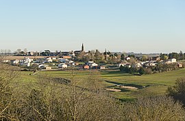 A general view of Lavalette | |
 Coat of arms | |
Location of Lavalette .mw-parser-output .locmap .od{position:absolute}.mw-parser-output .locmap .id{position:absolute;line-height:0}.mw-parser-output .locmap .l0{font-size:0;position:absolute}.mw-parser-output .locmap .pv{line-height:110%;position:absolute;text-align:center}.mw-parser-output .locmap .pl{line-height:110%;position:absolute;top:-0.75em;text-align:right}.mw-parser-output .locmap .pr{line-height:110%;position:absolute;top:-0.75em;text-align:left}.mw-parser-output .locmap .pv>div{display:inline;padding:1px}.mw-parser-output .locmap .pl>div{display:inline;padding:1px;float:right}.mw-parser-output .locmap .pr>div{display:inline;padding:1px;float:left}html.skin-theme-clientpref-night .mw-parser-output .od,html.skin-theme-clientpref-night .mw-parser-output .od .pv>div,html.skin-theme-clientpref-night .mw-parser-output .od .pl>div,html.skin-theme-clientpref-night .mw-parser-output .od .pr>div{background:#000;color:#fff}html.skin-theme-clientpref-night .mw-parser-output .locmap{filter:grayscale(0.6)}@media(prefers-color-scheme:dark){html.skin-theme-clientpref-os .mw-parser-output .locmap{filter:grayscale(0.6)}html.skin-theme-clientpref-os .mw-parser-output .od,html.skin-theme-clientpref-os .mw-parser-output .od .pv>div,html.skin-theme-clientpref-os .mw-parser-output .od .pl>div,html.skin-theme-clientpref-os .mw-parser-output .od .pr>div{background:#000;color:#fff}}  Lavalette  Lavalette | |
| Coordinates: 43°38′19″N 1°35′48″E / 43.6386°N 1.5967°E | |
| Country | France |
| Region | Occitania |
| Department | Haute-Garonne |
| Arrondissement | Toulouse |
| Canton | Pechbonnieu |
| Government | |
| • Mayor (2020–2026) | André Fontés[1] |
| Area 1 | 13.75 km2 (5.31 sq mi) |
| Population (2021)[2] | 803 |
| • Density | 58/km2 (150/sq mi) |
| Time zone | UTC+01:00 (CET) |
| • Summer (DST) | UTC+02:00 (CEST) |
| INSEE/Postal code | 31285 /31590 |
| Elevation | 155–233 m (509–764 ft) (avg. 221 m or 725 ft) |
| 1 French Land Register data, which excludes lakes, ponds, glaciers > 1 km2 (0.386 sq mi or 247 acres) and river estuaries. | |
Population edit
| Year | Pop. | ±% |
|---|---|---|
| 1962 | 342 | — |
| 1968 | 355 | +3.8% |
| 1975 | 406 | +14.4% |
| 1982 | 503 | +23.9% |
| 1990 | 531 | +5.6% |
| 1999 | 602 | +13.4% |
| 2006 | 618 | +2.7% |
| 2007 | 621 | +0.5% |
| 2008 | 624 | +0.5% |
| 2013 | 686 | +9.9% |
| 2015 | 727 | +6.0% |
| 2018 | 743 | +2.2% |
The inhabitants of the commune are known as Lavalettois.
Monument edit
-
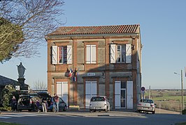
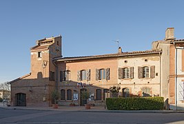 Town hall
 -
 Church Saint-Laurent
 -
 Church Saint-Laurent
 -
 School


See also edit
References edit
- ^ "Répertoire national des élus: les maires". data.gouv.fr, Plateforme ouverte des données publiques françaises (in French). 2 December 2020.
- ^ "Populations légales 2021". The National Institute of Statistics and Economic Studies. 28 December 2023.
Wikimedia Commons has media related to Lavalette (Haute-Garonne).