
KNOWPIA
WELCOME TO KNOWPIA

Lawang Bato 
Summary
Lawang Bato (lit. 'Stone Lake') is a barangay in Valenzuela, Metro Manila, Philippines. The name "Lawang Bato" came from the once rocky land where the barangay once stood.[2]
Lawang Bato | |
|---|---|
 Lawang Bato Barangay Hall | |
.mw-parser-output .locmap .od{position:absolute}.mw-parser-output .locmap .id{position:absolute;line-height:0}.mw-parser-output .locmap .l0{font-size:0;position:absolute}.mw-parser-output .locmap .pv{line-height:110%;position:absolute;text-align:center}.mw-parser-output .locmap .pl{line-height:110%;position:absolute;top:-0.75em;text-align:right}.mw-parser-output .locmap .pr{line-height:110%;position:absolute;top:-0.75em;text-align:left}.mw-parser-output .locmap .pv>div{display:inline;padding:1px}.mw-parser-output .locmap .pl>div{display:inline;padding:1px;float:right}.mw-parser-output .locmap .pr>div{display:inline;padding:1px;float:left}html.skin-theme-clientpref-night .mw-parser-output .od,html.skin-theme-clientpref-night .mw-parser-output .od .pv>div,html.skin-theme-clientpref-night .mw-parser-output .od .pl>div,html.skin-theme-clientpref-night .mw-parser-output .od .pr>div{background:#000;color:#fff}html.skin-theme-clientpref-night .mw-parser-output .locmap{filter:grayscale(0.6)}@media(prefers-color-scheme:dark){html.skin-theme-clientpref-os .mw-parser-output .locmap{filter:grayscale(0.6)}html.skin-theme-clientpref-os .mw-parser-output .od,html.skin-theme-clientpref-os .mw-parser-output .od .pv>div,html.skin-theme-clientpref-os .mw-parser-output .od .pl>div,html.skin-theme-clientpref-os .mw-parser-output .od .pr>div{background:#000;color:#fff}}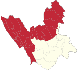 Lawang Bato Location of Lawang Bato in the 1st Valenzuela legislative district | |
| Coordinates: 14°43′48″N 120°59′46″E / 14.73000°N 120.99611°E | |
| Country | Philippines |
| Region | National Capital Region |
| City | Valenzuela |
| Congressional districts | Part of the 1st district of Valenzuela |
| Government | |
| • Barangay chairman | Orestes Ramirez Tolentino |
| Area | |
| • Total | 2.875 km2 (1.110 sq mi) |
| Population (2020[1]) | |
| • Total | 23,786 |
| • Density | 8,300/km2 (21,000/sq mi) |
Demographics edit
Area: 2.875 km2 Population: 23786 (2020)[1] Households: 5064 (2015)

Education edit
- Lawang Bato National High School. Founded in 1967. The current principal is MR.Eddie Alarte
- Lawang Bato Elementary School
- Charis Christian School of Val. Inc.
- Saint Joseph School of Lawang Bato
References edit
Wikimedia Commons has media related to Lawang Bato, Valenzuela.
14°43′48″N 120°59′46″E / 14.73000°N 120.99611°E