
KNOWPIA
WELCOME TO KNOWPIA

Le Hamel, Somme 
Summary
Le Hamel (French pronunciation: [lə amɛl]) is a commune in the Somme department and Hauts-de-France region of northern France.
Le Hamel | |
|---|---|
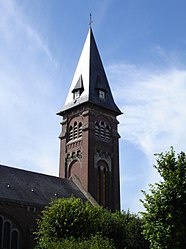 The church in Le Hamel | |
 Coat of arms | |
Location of Le Hamel .mw-parser-output .locmap .od{position:absolute}.mw-parser-output .locmap .id{position:absolute;line-height:0}.mw-parser-output .locmap .l0{font-size:0;position:absolute}.mw-parser-output .locmap .pv{line-height:110%;position:absolute;text-align:center}.mw-parser-output .locmap .pl{line-height:110%;position:absolute;top:-0.75em;text-align:right}.mw-parser-output .locmap .pr{line-height:110%;position:absolute;top:-0.75em;text-align:left}.mw-parser-output .locmap .pv>div{display:inline;padding:1px}.mw-parser-output .locmap .pl>div{display:inline;padding:1px;float:right}.mw-parser-output .locmap .pr>div{display:inline;padding:1px;float:left}html.skin-theme-clientpref-night .mw-parser-output .od,html.skin-theme-clientpref-night .mw-parser-output .od .pv>div,html.skin-theme-clientpref-night .mw-parser-output .od .pl>div,html.skin-theme-clientpref-night .mw-parser-output .od .pr>div{background:#000;color:#fff}html.skin-theme-clientpref-night .mw-parser-output .locmap{filter:grayscale(0.6)}@media(prefers-color-scheme:dark){html.skin-theme-clientpref-os .mw-parser-output .locmap{filter:grayscale(0.6)}html.skin-theme-clientpref-os .mw-parser-output .od,html.skin-theme-clientpref-os .mw-parser-output .od .pv>div,html.skin-theme-clientpref-os .mw-parser-output .od .pl>div,html.skin-theme-clientpref-os .mw-parser-output .od .pr>div{background:#000;color:#fff}}  Le Hamel  Le Hamel | |
| Coordinates: 49°53′00″N 2°34′00″E / 49.8833°N 2.5667°E | |
| Country | France |
| Region | Hauts-de-France |
| Department | Somme |
| Arrondissement | Amiens |
| Canton | Corbie |
| Intercommunality | Val de Somme |
| Government | |
| • Mayor (2020–2026) | Stéphane Chevin[1] |
| Area 1 | 9.12 km2 (3.52 sq mi) |
| Population (2021)[2] | 484 |
| • Density | 53/km2 (140/sq mi) |
| Time zone | UTC+01:00 (CET) |
| • Summer (DST) | UTC+02:00 (CEST) |
| INSEE/Postal code | 80411 /80800 |
| Elevation | 28–101 m (92–331 ft) (avg. 83 m or 272 ft) |
| 1 French Land Register data, which excludes lakes, ponds, glaciers > 1 km2 (0.386 sq mi or 247 acres) and river estuaries. | |
Geography edit
Le Hamel is situated some 20 km east of Amiens in the valley of the Somme. The surrounding district is the historical Santerre, a lightly wooded and agricultural plateau.
History edit
The settlement is first documented in 1184 as belonging to the powerful abbey of Corbie. The name has the same root as hameau ("hamlet"), a small rural settlement.
The town and surrounding countryside was the scene of the Battle of Hamel on 4 July 1918, during World War I. The battle, despite being small in scale, is notable for being the first instance in which combined arms tactics were used in warfare.
Places of interest edit
- A park commemorating the 1000+ Australian troops who died in the Battle of Hamel was inaugurated on 4 July 1998, exactly 80 years after the date of the event. The site symbolises the friendship between France and Australia.
- The lakes of the Somme valley.
-
 The Mairie
 -
 The High Street


Population edit
|
| ||||||||||||||||||||||||||||||||||||||||||||||||||||||||||||||||||||||||||||||||||||||||||||||||||||||||||||||||||
| Source: EHESS[3] and INSEE (1968-2017)[4] | |||||||||||||||||||||||||||||||||||||||||||||||||||||||||||||||||||||||||||||||||||||||||||||||||||||||||||||||||||
See also edit
References edit
- ^ "Répertoire national des élus: les maires". data.gouv.fr, Plateforme ouverte des données publiques françaises (in French). 2 December 2020.
- ^ "Populations légales 2021". The National Institute of Statistics and Economic Studies. 28 December 2023.
- ^ Des villages de Cassini aux communes d'aujourd'hui: Commune data sheet Le Hamel, EHESS (in French).
- ^ Population en historique depuis 1968, INSEE
External links edit
Wikimedia Commons has media related to Le Hamel (Somme).
- Le Hamel
- Santerre 14-18 : World War I in the Santerre