
KNOWPIA
WELCOME TO KNOWPIA

Le Hanouard 
Summary
Le Hanouard (French pronunciation: [lə anwaʁ]) is a commune in the Seine-Maritime department in the Normandy region in northern France.
Le Hanouard | |
|---|---|
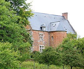 The manor of Le Hanouard | |
 Coat of arms | |
Location of Le Hanouard .mw-parser-output .locmap .od{position:absolute}.mw-parser-output .locmap .id{position:absolute;line-height:0}.mw-parser-output .locmap .l0{font-size:0;position:absolute}.mw-parser-output .locmap .pv{line-height:110%;position:absolute;text-align:center}.mw-parser-output .locmap .pl{line-height:110%;position:absolute;top:-0.75em;text-align:right}.mw-parser-output .locmap .pr{line-height:110%;position:absolute;top:-0.75em;text-align:left}.mw-parser-output .locmap .pv>div{display:inline;padding:1px}.mw-parser-output .locmap .pl>div{display:inline;padding:1px;float:right}.mw-parser-output .locmap .pr>div{display:inline;padding:1px;float:left}html.skin-theme-clientpref-night .mw-parser-output .od,html.skin-theme-clientpref-night .mw-parser-output .od .pv>div,html.skin-theme-clientpref-night .mw-parser-output .od .pl>div,html.skin-theme-clientpref-night .mw-parser-output .od .pr>div{background:#000;color:#fff}html.skin-theme-clientpref-night .mw-parser-output .locmap{filter:grayscale(0.6)}@media(prefers-color-scheme:dark){html.skin-theme-clientpref-os .mw-parser-output .locmap{filter:grayscale(0.6)}html.skin-theme-clientpref-os .mw-parser-output .od,html.skin-theme-clientpref-os .mw-parser-output .od .pv>div,html.skin-theme-clientpref-os .mw-parser-output .od .pl>div,html.skin-theme-clientpref-os .mw-parser-output .od .pr>div{background:#000;color:#fff}}  Le Hanouard  Le Hanouard | |
| Coordinates: 49°43′49″N 0°39′49″E / 49.7303°N 0.6636°E | |
| Country | France |
| Region | Normandy |
| Department | Seine-Maritime |
| Arrondissement | Dieppe |
| Canton | Saint-Valery-en-Caux |
| Intercommunality | CC Côte d'Albâtre |
| Government | |
| • Mayor (2020–2026) | Jacques Leballeur[1] |
| Area 1 | 4.32 km2 (1.67 sq mi) |
| Population (2021)[2] | 261 |
| • Density | 60/km2 (160/sq mi) |
| Time zone | UTC+01:00 (CET) |
| • Summer (DST) | UTC+02:00 (CEST) |
| INSEE/Postal code | 76339 /76450 |
| Elevation | 36–142 m (118–466 ft) (avg. 85 m or 279 ft) |
| 1 French Land Register data, which excludes lakes, ponds, glaciers > 1 km2 (0.386 sq mi or 247 acres) and river estuaries. | |
Geography edit
A farming village surrounded by woodland in the Pays de Caux, some 32 miles (51 km) northeast of Le Havre, at the junction of the D131 and D109 roads and by the banks of the river Durdent.
Heraldry edit
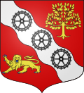 |
The arms of Le Hanouard are blazoned : Gules, on a bend wavy argent between an apple tree and a leopard Or armed and langued azure, 3 millwheels sable.
|
Population edit
| Year | Pop. | ±% p.a. |
|---|---|---|
| 1968 | 234 | — |
| 1975 | 226 | −0.50% |
| 1982 | 287 | +3.47% |
| 1990 | 266 | −0.95% |
| 1999 | 273 | +0.29% |
| 2007 | 218 | −2.77% |
| 2012 | 246 | +2.45% |
| 2017 | 249 | +0.24% |
| Source: INSEE[3] | ||
Places of interest edit
- The church of St. Denis-et-Sainte-Cécile, dating from the seventeenth century.
See also edit
References edit
- ^ "Répertoire national des élus: les maires" (in French). data.gouv.fr, Plateforme ouverte des données publiques françaises. 13 September 2022.
- ^ "Populations légales 2021". The National Institute of Statistics and Economic Studies. 28 December 2023.
- ^ Population en historique depuis 1968, INSEE
Wikimedia Commons has media related to Le Hanouard.