
KNOWPIA
WELCOME TO KNOWPIA

Le Mesnil-Aubert 
Summary
Le Mesnil-Aubert (French pronunciation: [lə menil obɛʁ]) is a commune in the Manche department in Normandy in north-western France.
Le Mesnil-Aubert | |
|---|---|
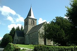 The church of Saint-Pierre | |
Location of Le Mesnil-Aubert .mw-parser-output .locmap .od{position:absolute}.mw-parser-output .locmap .id{position:absolute;line-height:0}.mw-parser-output .locmap .l0{font-size:0;position:absolute}.mw-parser-output .locmap .pv{line-height:110%;position:absolute;text-align:center}.mw-parser-output .locmap .pl{line-height:110%;position:absolute;top:-0.75em;text-align:right}.mw-parser-output .locmap .pr{line-height:110%;position:absolute;top:-0.75em;text-align:left}.mw-parser-output .locmap .pv>div{display:inline;padding:1px}.mw-parser-output .locmap .pl>div{display:inline;padding:1px;float:right}.mw-parser-output .locmap .pr>div{display:inline;padding:1px;float:left}html.skin-theme-clientpref-night .mw-parser-output .od,html.skin-theme-clientpref-night .mw-parser-output .od .pv>div,html.skin-theme-clientpref-night .mw-parser-output .od .pl>div,html.skin-theme-clientpref-night .mw-parser-output .od .pr>div{background:#000;color:#fff}html.skin-theme-clientpref-night .mw-parser-output .locmap{filter:grayscale(0.6)}@media(prefers-color-scheme:dark){html.skin-theme-clientpref-os .mw-parser-output .locmap{filter:grayscale(0.6)}html.skin-theme-clientpref-os .mw-parser-output .od,html.skin-theme-clientpref-os .mw-parser-output .od .pv>div,html.skin-theme-clientpref-os .mw-parser-output .od .pl>div,html.skin-theme-clientpref-os .mw-parser-output .od .pr>div{background:#000;color:#fff}}  Le Mesnil-Aubert  Le Mesnil-Aubert | |
| Coordinates: 48°56′49″N 1°24′44″W / 48.9469°N 1.4122°W | |
| Country | France |
| Region | Normandy |
| Department | Manche |
| Arrondissement | Avranches |
| Canton | Bréhal |
| Intercommunality | Granville, Terre et Mer |
| Government | |
| • Mayor (2020–2026) | Catherine Simon[1] |
| Area 1 | 5.96 km2 (2.30 sq mi) |
| Population (2021)[2] | 195 |
| • Density | 33/km2 (85/sq mi) |
| Time zone | UTC+01:00 (CET) |
| • Summer (DST) | UTC+02:00 (CEST) |
| INSEE/Postal code | 50304 /50510 |
| Elevation | 14–117 m (46–384 ft) (avg. 20 m or 66 ft) |
| 1 French Land Register data, which excludes lakes, ponds, glaciers > 1 km2 (0.386 sq mi or 247 acres) and river estuaries. | |
See also edit
References edit
- ^ "Répertoire national des élus: les maires" (in French). data.gouv.fr, Plateforme ouverte des données publiques françaises. 13 September 2022.
- ^ "Populations légales 2021". The National Institute of Statistics and Economic Studies. 28 December 2023.
Wikimedia Commons has media related to Le Mesnil-Aubert.