
KNOWPIA
WELCOME TO KNOWPIA

Le Puley 
Summary
Le Puley (French pronunciation: [lə pylɛ]) is a commune in the Saône-et-Loire department in the region of Bourgogne-Franche-Comté in eastern France.
Le Puley | |
|---|---|
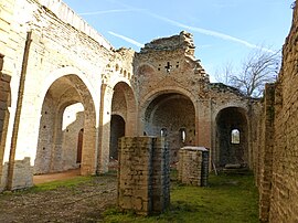 The Priory | |
 Coat of arms | |
Location of Le Puley .mw-parser-output .locmap .od{position:absolute}.mw-parser-output .locmap .id{position:absolute;line-height:0}.mw-parser-output .locmap .l0{font-size:0;position:absolute}.mw-parser-output .locmap .pv{line-height:110%;position:absolute;text-align:center}.mw-parser-output .locmap .pl{line-height:110%;position:absolute;top:-0.75em;text-align:right}.mw-parser-output .locmap .pr{line-height:110%;position:absolute;top:-0.75em;text-align:left}.mw-parser-output .locmap .pv>div{display:inline;padding:1px}.mw-parser-output .locmap .pl>div{display:inline;padding:1px;float:right}.mw-parser-output .locmap .pr>div{display:inline;padding:1px;float:left}html.skin-theme-clientpref-night .mw-parser-output .od,html.skin-theme-clientpref-night .mw-parser-output .od .pv>div,html.skin-theme-clientpref-night .mw-parser-output .od .pl>div,html.skin-theme-clientpref-night .mw-parser-output .od .pr>div{background:#000;color:#fff}html.skin-theme-clientpref-night .mw-parser-output .locmap{filter:grayscale(0.6)}@media(prefers-color-scheme:dark){html.skin-theme-clientpref-os .mw-parser-output .locmap{filter:grayscale(0.6)}html.skin-theme-clientpref-os .mw-parser-output .od,html.skin-theme-clientpref-os .mw-parser-output .od .pv>div,html.skin-theme-clientpref-os .mw-parser-output .od .pl>div,html.skin-theme-clientpref-os .mw-parser-output .od .pr>div{background:#000;color:#fff}}  Le Puley  Le Puley | |
| Coordinates: 46°40′45″N 4°33′52″E / 46.6792°N 4.5644°E | |
| Country | France |
| Region | Bourgogne-Franche-Comté |
| Department | Saône-et-Loire |
| Arrondissement | Chalon-sur-Saône |
| Canton | Blanzy |
| Area 1 | 5.3 km2 (2.0 sq mi) |
| Population (2021)[1] | 81 |
| • Density | 15/km2 (40/sq mi) |
| Time zone | UTC+01:00 (CET) |
| • Summer (DST) | UTC+02:00 (CEST) |
| INSEE/Postal code | 71363 /71460 |
| Elevation | 249–421 m (817–1,381 ft) (avg. 260 m or 850 ft) |
| 1 French Land Register data, which excludes lakes, ponds, glaciers > 1 km2 (0.386 sq mi or 247 acres) and river estuaries. | |
Geography edit
The main roads are connecting the village to Germagny and Genouilly to the south and Saint-Micaud to the north.
Main sights edit
The romanesque priory "Saint Christophe" (12th century), protected in 1973 by the French National Heritage as a Monument historique.[2] The belltower collapsed on the building in 1877, causing major damages.
See also edit
- Guillaume des Autels who used to own a château named "des Hôtels" in le Puley.
- Communes of the Saône-et-Loire department
References edit
- ^ "Populations légales 2021". The National Institute of Statistics and Economic Studies. 28 December 2023.
- ^ Base Mérimée: Monument historique registration number PA00113395, Ministère français de la Culture. (in French)
Wikimedia Commons has media related to Le Puley.