
KNOWPIA
WELCOME TO KNOWPIA

Le Teilleul 
Summary
Le Teilleul (French pronunciation: [lə.tɛj'œl]) is a commune in the Manche department in Normandy in north-western France. On 1 January 2016, the former communes of Ferrières, Heussé, Husson and Sainte-Marie-du-Bois were merged into Le Teilleul.[3]
Le Teilleul | |
|---|---|
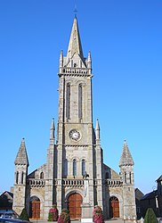 The church in Le Teilleul | |
 Coat of arms | |
Location of Le Teilleul .mw-parser-output .locmap .od{position:absolute}.mw-parser-output .locmap .id{position:absolute;line-height:0}.mw-parser-output .locmap .l0{font-size:0;position:absolute}.mw-parser-output .locmap .pv{line-height:110%;position:absolute;text-align:center}.mw-parser-output .locmap .pl{line-height:110%;position:absolute;top:-0.75em;text-align:right}.mw-parser-output .locmap .pr{line-height:110%;position:absolute;top:-0.75em;text-align:left}.mw-parser-output .locmap .pv>div{display:inline;padding:1px}.mw-parser-output .locmap .pl>div{display:inline;padding:1px;float:right}.mw-parser-output .locmap .pr>div{display:inline;padding:1px;float:left}html.skin-theme-clientpref-night .mw-parser-output .od,html.skin-theme-clientpref-night .mw-parser-output .od .pv>div,html.skin-theme-clientpref-night .mw-parser-output .od .pl>div,html.skin-theme-clientpref-night .mw-parser-output .od .pr>div{background:#000;color:#fff}html.skin-theme-clientpref-night .mw-parser-output .locmap{filter:grayscale(0.6)}@media(prefers-color-scheme:dark){html.skin-theme-clientpref-os .mw-parser-output .locmap{filter:grayscale(0.6)}html.skin-theme-clientpref-os .mw-parser-output .od,html.skin-theme-clientpref-os .mw-parser-output .od .pv>div,html.skin-theme-clientpref-os .mw-parser-output .od .pl>div,html.skin-theme-clientpref-os .mw-parser-output .od .pr>div{background:#000;color:#fff}}  Le Teilleul  Le Teilleul | |
| Coordinates: 48°32′21″N 0°52′25″W / 48.5393°N 0.8735°W | |
| Country | France |
| Region | Normandy |
| Department | Manche |
| Arrondissement | Avranches |
| Canton | Le Mortainais |
| Intercommunality | CA Mont-Saint-Michel-Normandie |
| Government | |
| • Mayor (2020–2026) | Véronique Künkel[1] |
| Area 1 | 66.89 km2 (25.83 sq mi) |
| Population (2021)[2] | 1,677 |
| • Density | 25/km2 (65/sq mi) |
| Demonym | Teilleulais et Teilleulaise |
| Time zone | UTC+01:00 (CET) |
| • Summer (DST) | UTC+02:00 (CEST) |
| INSEE/Postal code | 50591 /50640 |
| Elevation | 103–222 m (338–728 ft) (avg. 212 m or 696 ft) |
| 1 French Land Register data, which excludes lakes, ponds, glaciers > 1 km2 (0.386 sq mi or 247 acres) and river estuaries. | |
Heraldry edit
 |
The arms of Le Teilleul are blazoned : Azure, 3 horseshoes argent. |
See also edit
References edit
- ^ "Répertoire national des élus: les maires" (in French). data.gouv.fr, Plateforme ouverte des données publiques françaises. 13 September 2022.
- ^ "Populations légales 2021". The National Institute of Statistics and Economic Studies. 28 December 2023.
- ^ Arrêté préfectoral 9 December 2015 (in French)
Wikimedia Commons has media related to Le Teilleul.