
KNOWPIA
WELCOME TO KNOWPIA

Le Vast 
Summary
Le Vast (French pronunciation: [lə va]) is a commune in the Manche department in Normandy in north-western France. The village is located in the North-East of the Cotentin Peninsula in an area known as Val de Saire, literally the Vale the River Saire.
Le Vast | |
|---|---|
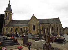 Notre-Dame church | |
Location of Le Vast .mw-parser-output .locmap .od{position:absolute}.mw-parser-output .locmap .id{position:absolute;line-height:0}.mw-parser-output .locmap .l0{font-size:0;position:absolute}.mw-parser-output .locmap .pv{line-height:110%;position:absolute;text-align:center}.mw-parser-output .locmap .pl{line-height:110%;position:absolute;top:-0.75em;text-align:right}.mw-parser-output .locmap .pr{line-height:110%;position:absolute;top:-0.75em;text-align:left}.mw-parser-output .locmap .pv>div{display:inline;padding:1px}.mw-parser-output .locmap .pl>div{display:inline;padding:1px;float:right}.mw-parser-output .locmap .pr>div{display:inline;padding:1px;float:left}html.skin-theme-clientpref-night .mw-parser-output .od,html.skin-theme-clientpref-night .mw-parser-output .od .pv>div,html.skin-theme-clientpref-night .mw-parser-output .od .pl>div,html.skin-theme-clientpref-night .mw-parser-output .od .pr>div{background:#000;color:#fff}html.skin-theme-clientpref-night .mw-parser-output .locmap{filter:grayscale(0.6)}@media(prefers-color-scheme:dark){html.skin-theme-clientpref-os .mw-parser-output .locmap{filter:grayscale(0.6)}html.skin-theme-clientpref-os .mw-parser-output .od,html.skin-theme-clientpref-os .mw-parser-output .od .pv>div,html.skin-theme-clientpref-os .mw-parser-output .od .pl>div,html.skin-theme-clientpref-os .mw-parser-output .od .pr>div{background:#000;color:#fff}}  Le Vast  Le Vast | |
| Coordinates: 49°37′24″N 1°21′23″W / 49.6233°N 1.3564°W | |
| Country | France |
| Region | Normandy |
| Department | Manche |
| Arrondissement | Cherbourg |
| Canton | Val-de-Saire |
| Intercommunality | CA Cotentin |
| Government | |
| • Mayor (2020–2026) | Luc Solier[1] |
| Area 1 | 13.04 km2 (5.03 sq mi) |
| Population (2021)[2] | 328 |
| • Density | 25/km2 (65/sq mi) |
| Time zone | UTC+01:00 (CET) |
| • Summer (DST) | UTC+02:00 (CEST) |
| INSEE/Postal code | 50619 /50630 |
| Elevation | 24–107 m (79–351 ft) (avg. 44 m or 144 ft) |
| 1 French Land Register data, which excludes lakes, ponds, glaciers > 1 km2 (0.386 sq mi or 247 acres) and river estuaries. | |
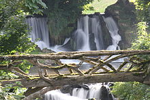
The river used to power several mills including a cotton mill established by Philippe Fontenilliat in 1803. It employed up to 600 workers until it closed in 1858. The mill has now been replaced by the "Château de La Germonière". The grounds are open to the public on certain occasions. One of its main features is its set of two artificial waterfalls on the river which can be seen from the main road.
See also edit
References edit
- ^ "Répertoire national des élus: les maires". data.gouv.fr, Plateforme ouverte des données publiques françaises (in French). 2 December 2020.
- ^ "Populations légales 2021". The National Institute of Statistics and Economic Studies. 28 December 2023.
External links edit
- Brioche of Le Vast; history of the famous local delicacy with images
Wikimedia Commons has media related to Le Vast.