
KNOWPIA
WELCOME TO KNOWPIA

Lecelles 
Summary
Lecelles (French pronunciation: [ləsɛl]) is a commune in the Nord department in northern France.[3]
Lecelles | |
|---|---|
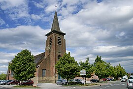 Lecelles, church: église Saint-Denis | |
 Coat of arms | |
Location of Lecelles .mw-parser-output .locmap .od{position:absolute}.mw-parser-output .locmap .id{position:absolute;line-height:0}.mw-parser-output .locmap .l0{font-size:0;position:absolute}.mw-parser-output .locmap .pv{line-height:110%;position:absolute;text-align:center}.mw-parser-output .locmap .pl{line-height:110%;position:absolute;top:-0.75em;text-align:right}.mw-parser-output .locmap .pr{line-height:110%;position:absolute;top:-0.75em;text-align:left}.mw-parser-output .locmap .pv>div{display:inline;padding:1px}.mw-parser-output .locmap .pl>div{display:inline;padding:1px;float:right}.mw-parser-output .locmap .pr>div{display:inline;padding:1px;float:left}html.skin-theme-clientpref-night .mw-parser-output .od,html.skin-theme-clientpref-night .mw-parser-output .od .pv>div,html.skin-theme-clientpref-night .mw-parser-output .od .pl>div,html.skin-theme-clientpref-night .mw-parser-output .od .pr>div{background:#000;color:#fff}html.skin-theme-clientpref-night .mw-parser-output .locmap{filter:grayscale(0.6)}@media(prefers-color-scheme:dark){html.skin-theme-clientpref-os .mw-parser-output .locmap{filter:grayscale(0.6)}html.skin-theme-clientpref-os .mw-parser-output .od,html.skin-theme-clientpref-os .mw-parser-output .od .pv>div,html.skin-theme-clientpref-os .mw-parser-output .od .pl>div,html.skin-theme-clientpref-os .mw-parser-output .od .pr>div{background:#000;color:#fff}}  Lecelles  Lecelles | |
| Coordinates: 50°28′17″N 3°23′43″E / 50.4714°N 3.3953°E | |
| Country | France |
| Region | Hauts-de-France |
| Department | Nord |
| Arrondissement | Valenciennes |
| Canton | Saint-Amand-les-Eaux |
| Intercommunality | CA Porte du Hainaut |
| Government | |
| • Mayor (2020–2026) | Jean-Claude Messager[1] |
| Area 1 | 16.24 km2 (6.27 sq mi) |
| Population (2021)[2] | 3,004 |
| • Density | 180/km2 (480/sq mi) |
| Time zone | UTC+01:00 (CET) |
| • Summer (DST) | UTC+02:00 (CEST) |
| INSEE/Postal code | 59335 /59226 |
| Elevation | 15–26 m (49–85 ft) (avg. 17 m or 56 ft) |
| 1 French Land Register data, which excludes lakes, ponds, glaciers > 1 km2 (0.386 sq mi or 247 acres) and river estuaries. | |
Population edit
| Year | Pop. | ±% p.a. |
|---|---|---|
| 1968 | 2,152 | — |
| 1975 | 2,356 | +1.30% |
| 1982 | 2,402 | +0.28% |
| 1990 | 2,563 | +0.81% |
| 1999 | 2,662 | +0.42% |
| 2007 | 2,733 | +0.33% |
| 2012 | 2,684 | −0.36% |
| 2017 | 2,810 | +0.92% |
| Source: INSEE[4] | ||
Gallery edit
-
 Lecelles, war memorial
 -
 Lecelles, view to a street
 -
 Lecelles, view to a street


Heraldry edit
 |
The arms of Lecelles are blazoned : Azure, semy de lys Or. = France Ancient (Ansacq, Brillon, Escaudain, Escautpont, Hélesmes, Hérin, Lecelles, Lieu-Saint-Amand, Lourches, Neuville-sur-Escaut, Rosult, Rumegies and Wignehies use the same arms.)
|
See also edit
References edit
- ^ "Répertoire national des élus: les maires". data.gouv.fr, Plateforme ouverte des données publiques françaises (in French). 2 December 2020.
- ^ "Populations légales 2021". The National Institute of Statistics and Economic Studies. 28 December 2023.
- ^ INSEE commune file
- ^ Population en historique depuis 1968, INSEE
Wikimedia Commons has media related to Lecelles.