


Summary
Lescun (French pronunciation: [lɛskœ̃][3]) is a village and a commune in the Pyrénées-Atlantiques department in south-western France.[4]
Lescun | |
|---|---|
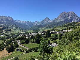 View of Lescun | |
Location of Lescun .mw-parser-output .locmap .od{position:absolute}.mw-parser-output .locmap .id{position:absolute;line-height:0}.mw-parser-output .locmap .l0{font-size:0;position:absolute}.mw-parser-output .locmap .pv{line-height:110%;position:absolute;text-align:center}.mw-parser-output .locmap .pl{line-height:110%;position:absolute;top:-0.75em;text-align:right}.mw-parser-output .locmap .pr{line-height:110%;position:absolute;top:-0.75em;text-align:left}.mw-parser-output .locmap .pv>div{display:inline;padding:1px}.mw-parser-output .locmap .pl>div{display:inline;padding:1px;float:right}.mw-parser-output .locmap .pr>div{display:inline;padding:1px;float:left}html.skin-theme-clientpref-night .mw-parser-output .od,html.skin-theme-clientpref-night .mw-parser-output .od .pv>div,html.skin-theme-clientpref-night .mw-parser-output .od .pl>div,html.skin-theme-clientpref-night .mw-parser-output .od .pr>div{background:#000;color:#fff}html.skin-theme-clientpref-night .mw-parser-output .locmap{filter:grayscale(0.6)}@media(prefers-color-scheme:dark){html.skin-theme-clientpref-os .mw-parser-output .locmap{filter:grayscale(0.6)}html.skin-theme-clientpref-os .mw-parser-output .od,html.skin-theme-clientpref-os .mw-parser-output .od .pv>div,html.skin-theme-clientpref-os .mw-parser-output .od .pl>div,html.skin-theme-clientpref-os .mw-parser-output .od .pr>div{background:#000;color:#fff}}  Lescun  Lescun | |
| Coordinates: 42°56′06″N 0°38′01″W / 42.935°N 0.6336°W | |
| Country | France |
| Region | Nouvelle-Aquitaine |
| Department | Pyrénées-Atlantiques |
| Arrondissement | Oloron-Sainte-Marie |
| Canton | Oloron-Sainte-Marie-1 |
| Government | |
| • Mayor (2020–2026) | Danielle Gay[1] |
| Area 1 | 61 km2 (24 sq mi) |
| Population (2021)[2] | 171 |
| • Density | 2.8/km2 (7.3/sq mi) |
| Time zone | UTC+01:00 (CET) |
| • Summer (DST) | UTC+02:00 (CEST) |
| INSEE/Postal code | 64336 /64490 |
| Elevation | 468–2,504 m (1,535–8,215 ft) (avg. 900 m or 3,000 ft) |
| 1 French Land Register data, which excludes lakes, ponds, glaciers > 1 km2 (0.386 sq mi or 247 acres) and river estuaries. | |
It is at an elevation of approximately 900 metres (3,000 feet) in a grand cirque.
Lescun is situated on the GR 10 long-distance footpath traversing the Pyrenees. Combined with the dramatic scenery of its mountain backdrop, this makes it a popular focus for hikers and climbers.[5] Several lakes and summits can for example be reached from Lescun, including the lake of Lhurs, the lake of Ansabère, the Billare, the Pic d'Anie, and the Grande Aiguille d'Ansabère.
With its old buildings and narrow streets, Lescun exudes a pleasant old village charm.
Lescun in popular culture edit
Lescun the setting for the book Waiting for Anya by Michael Morpurgo.
See also edit
- Another distant picture
- Communes of the Pyrénées-Atlantiques department
References edit
- ^ "Répertoire national des élus: les maires" (in French). data.gouv.fr, Plateforme ouverte des données publiques françaises. 13 September 2022.
- ^ "Populations légales 2021". The National Institute of Statistics and Economic Studies. 28 December 2023.
- ^ France 3 Nouvelle-Aquitaine. "Lescun: les recherches s'intensifient pour retrouver le randonneur disparu".
{{cite web}}: CS1 maint: numeric names: authors list (link) - ^ INSEE commune file
- ^ Randonnées à Lescun, Tourisme64
External links edit
- Lescun panorama