


Summary
Leshukonsky District (Russian: Лешуко́нский райо́н) is an administrative district (raion), one of the twenty-one in Arkhangelsk Oblast, Russia.[1] Municipally, it is incorporated as Leshukonsky Municipal District.[7] It is located in the northeast of the oblast and borders with Mezensky District in the north, Ust-Tsilemsky District of the Komi Republic in the east, Udorsky District of the Komi Republic in the south, and with Pinezhsky District in the west.[9] Its administrative center is the rural locality (a selo) of Leshukonskoye.[3] District's population: 7,979 (2010 Census);[5] 10,708 (2002 Census);[10] 15,488 (1989 Census).[11] The population of Leshukonskoye accounts for 55.2% of the district's population.[5]
Leshukonsky District
Лешуконский район | |
|---|---|
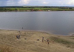 Riverbank scene, Leshukonsky District | |
 Flag  Coat of arms | |
 Location of Leshukonsky District in Arkhangelsk Oblast | |
| Coordinates: 64°54′N 45°46′E / 64.900°N 45.767°E | |
| Country | Russia |
| Federal subject | Arkhangelsk Oblast[1] |
| Established | July 15, 1929[2] |
| Administrative center | Leshukonskoye[3] |
| Area | |
| • Total | 28,100 km2 (10,800 sq mi) |
| Population | |
| • Total | 7,979 |
| • Estimate (2018)[6] | 6,410 (−19.7%) |
| • Density | 0.28/km2 (0.74/sq mi) |
| • Urban | 0% |
| • Rural | 100% |
| Administrative structure | |
| • Administrative divisions | 7 selsoviet |
| • Inhabited localities[3] | 47 rural localities |
| Municipal structure | |
| • Municipally incorporated as | Leshukonsky Municipal District[7] |
| • Municipal divisions[7] | 0 urban settlements, 6 rural settlements |
| Time zone | UTC+3 (MSK |
| OKTMO ID | 11638000 |
| Website | http://www.leshukonia.ru/ |
History edit
The area was populated by speakers of Uralic languages and then colonized by the Novgorod Republic. After the fall of Novgorod, the area became a part of the Grand Duchy of Moscow. First Russian settlements on the Mezen River were mentioned in the 16th century: Yuroma (1513) and Koynas (1554).[2] The middle course of the Mezen, the current area of the district, was where Russian and Komi cultures mixed the most.[12]
In the course of the administrative reform carried out in 1708 by Peter the Great, the area was included into Archangelgorod Governorate. In 1780, the governorate was abolished and transformed into Vologda Viceroyalty. In 1796, the area was transferred to Arkhangelsk Governorate. The current territory of the district was included into Mezensky Uyezd. On December 28, 1917, a new Ust-Vashsky Uyezd with the administrative center in Ust-Vashka (currently Leshukonskoye) was established; however, in 1925 it was merged back into Mezensky Uyezd.[2]
In 1929, several governorates were merged into Northern Krai. On July 15, 1929, the uyezds were abolished, and Leshukonsky District was established. It became a part of Arkhangelsk Okrug of Northern Krai. In the following years, the first-level administrative division of Russia kept changing. In 1930, the okrug was abolished, and the district was subordinated to the central administration of Northern Krai. In 1936, the krai itself was transformed into Northern Oblast. In 1937, Northern Oblast was split into Arkhangelsk Oblast and Vologda Oblast. Leshukonsky District remained in Arkhangelsk Oblast ever since.[13]
Geography edit
The district lies almost entirely in the basin of the Mezen River, which crosses the district from southeast to northwest, and of its major tributaries, the Mezenskaya Pizhma, the Sula, the Kyma, the Vashka, the Kimzha, and, in the northern part, the Pyoza. Minor areas in the west of the district lie in the basin of the Yezhuga River, a tributary of the Pinega, and into the Nemnyuga River, a tributary of the Kuloy. Some areas in the east of the district are in the basin of the major tributaries of the Pechora, the Tsilma, and the Pizhma. In particular, the source of the Tsilma River is located in the district. The divide between the White Sea (the Mezen) and the Barents Sea (the Pechora) runs thus through the eastern part of the district.
The northern part of the Timan Ridge lies in the district, creating the hilly landscape. Almost the whole of the district is covered by coniferous forests (taiga). There are many glacial lakes across the district.
Divisions edit
Administrative divisions edit
Administratively, the district is divided into seven selsoviets.[3] The following selsoviets have been established (the administrative centers are given in parentheses):[3]
- Leshukonsky (Leshukonskoye)
- Nisogorsky (Zaruchey)
- Olemsky (Olema)
- Suksky (Koynas)
- Tsenogorsky (Tsenogora)
- Vozhgorsky (Vozhgora)
- Yuromsky (Yuroma)
Municipal divisions edit
Municipally, the district is divided into six rural settlements (the administrative centers are given in parentheses):[7]
- Koynasskoye Rural Settlement (Koynas)
- Leshukonskoye Rural Settlement (Leshukonskoye)
- Olemskoye Rural Settlement (Olema)
- Tsenogorskoye Rural Settlement (Tsenogora)
- Vozhgorskoye Rural Settlement (Vozhgora)
- Yuromskoye Rural Settlement (Yuroma)
Economy edit
Industry edit
The backbone of the district's economy is the timber industry. However, although the district has the best timber resources in the area, poor infrastructure impedes the expansion of this industry.[9]
Agriculture edit
The special breed of horses, Mezen horse, was bred in the Mezen River valley. The Mezen horses are rather small but suitable for difficult work and easily survive cold winters.[14]
Transportation edit
The Mezen and the Vashka Rivers are both navigable within the district limits; however, there is no passenger navigation in Leshukonsky District except for the ferry crossing between Leshukonskoye and the village of Smolenets. The ferry connects to the all-seasonal road to Arkhangelsk. Until 2008, there were no all-seasonal roads in the district. During winter, temporary roads (zimniks) are built in snow; in summer, the air transport is the only means for passenger connections to Arkhangelsk and the rest of the world.
There is an airport in Leshukonskoye, with several weekly flights to Arkhangelsk. There are also three minor airports in Koynas,[15] Olema,[16] and Vozhgora.[17]
Demographics edit
In terms of population, the largest inhabited localities are Vozhgora and Leshukonskoye. The unemployment rate in October 2010 was 5.4%.[18]
Politics edit
The local representative body is the Assembly of Deputies of Leshukonsky District. It has seventeen elected members. Its chairperson is Tatyana Stukalova. The head of the municipal administration is Alexander Martynov.[18]
Culture and recreation edit
The district contains three objects classified as cultural and historical heritage by the Russian Federal law, and additionally thirty-nine objects classified as cultural and historical heritage of local importance.[19] Most of these are wooden churches and wooden rural houses built prior to 1917. The objects under federal protection are the St. Nicholas Church (1890), the Klokotov House (1879), and the wooden cross, all in the village of Zaozerye (also known as Kelchemgora). The Klokotov House was moved in 2004 to the Malye Korely open-air museum close to Arkhangelsk. The cross is also located in the same museum.[20]
The only state museum in the district is the Leshukonsky Museum, located in the selo of Leshukonskoye.[21]
References edit
Notes edit
- ^ a b Law #65-5-OZ
- ^ a b c Лешуконский район (in Russian). Лешуконский муниципальный район. Retrieved September 12, 2011.
- ^ a b c d e Государственный комитет Российской Федерации по статистике. Комитет Российской Федерации по стандартизации, метрологии и сертификации. №ОК 019-95 1 января 1997 г. «Общероссийский классификатор объектов административно-территориального деления. Код 11 238», в ред. изменения №278/2015 от 1 января 2016 г.. (State Statistics Committee of the Russian Federation. Committee of the Russian Federation on Standardization, Metrology, and Certification. #OK 019-95 January 1, 1997 Russian Classification of Objects of Administrative Division (OKATO). Code 11 238, as amended by the Amendment #278/2015 of January 1, 2016. ).
- ^ Лешуконский район (in Russian). Двина-Информ. Retrieved September 12, 2011.
- ^ a b c Russian Federal State Statistics Service (2011). Всероссийская перепись населения 2010 года. Том 1 [2010 All-Russian Population Census, vol. 1]. Всероссийская перепись населения 2010 года [2010 All-Russia Population Census] (in Russian). Federal State Statistics Service.
- ^ "26. Численность постоянного населения Российской Федерации по муниципальным образованиям на 1 января 2018 года". Federal State Statistics Service. Retrieved January 23, 2019.
- ^ a b c d Law #258-vneoch.-OZ
- ^ "Об исчислении времени". Официальный интернет-портал правовой информации (in Russian). June 3, 2011. Retrieved January 19, 2019.
- ^ a b "Leshukonsky District, Arkhangelsk Oblast". 2006. Retrieved September 12, 2011.
- ^ Russian Federal State Statistics Service (May 21, 2004). Численность населения России, субъектов Российской Федерации в составе федеральных округов, районов, городских поселений, сельских населённых пунктов – районных центров и сельских населённых пунктов с населением 3 тысячи и более человек [Population of Russia, Its Federal Districts, Federal Subjects, Districts, Urban Localities, Rural Localities—Administrative Centers, and Rural Localities with Population of Over 3,000] (XLS). Всероссийская перепись населения 2002 года [All-Russia Population Census of 2002] (in Russian).
- ^ Всесоюзная перепись населения 1989 г. Численность наличного населения союзных и автономных республик, автономных областей и округов, краёв, областей, районов, городских поселений и сёл-райцентров [All Union Population Census of 1989: Present Population of Union and Autonomous Republics, Autonomous Oblasts and Okrugs, Krais, Oblasts, Districts, Urban Settlements, and Villages Serving as District Administrative Centers]. Всесоюзная перепись населения 1989 года [All-Union Population Census of 1989] (in Russian). Институт демографии Национального исследовательского университета: Высшая школа экономики [Institute of Demography at the National Research University: Higher School of Economics]. 1989 – via Demoscope Weekly.
- ^ Иванова, Т. Г. (2003). К истории региона. Былины Мезени: Север Европейской России. Былины (Свод русского фольклора). Vol. 25. Saint-Petersburg: Наука. pp. 7–11. Retrieved August 5, 2011.
- ^ "Административно-территориальное деление Архангельской губернии в XVIII-XX вв. (Справка)" (in Russian). Архивы России. 2000. Archived from the original on July 24, 2011. Retrieved July 27, 2011.
- ^ Мезенская лошадь. Great Soviet Encyclopedia.
- ^ Аэропорт Койнас (in Russian). МойАрхангельск.Ру. Retrieved August 1, 2011.
- ^ Аэропорт Олема (in Russian). МойАрхангельск.Ру. Retrieved August 1, 2011.
- ^ Аэропорт Вожгора (in Russian). МойАрхангельск.Ру. Retrieved August 1, 2011.
- ^ a b "Leshukonsky Municipal District". Administration of Arkhangelsk Oblast. 2010. Retrieved September 12, 2011.
- ^ Памятники истории и культуры народов Российской Федерации (in Russian). Russian Ministry of Culture. Retrieved June 2, 2016.
- ^ О музее Малые Корелы (in Russian). Allross. Archived from the original on March 22, 2012. Retrieved August 1, 2011.
- ^ Лешуконский музей (in Russian). Российская сеть культурного наследия. Retrieved August 1, 2011.
Sources edit
- Архангельское областное Собрание депутатов. Областной закон №65-5-ОЗ от 23 сентября 2009 г. «Об административно-территориальном устройстве Архангельской области», в ред. Областного закона №232-13-ОЗ от 16 декабря 2014 г. «О внесении изменений в отдельные Областные Законы в сфере осуществления местного самоуправления и взаимодействия с некоммерческими организациями». Вступил в силу через десять дней со дня официального опубликования. Опубликован: "Волна", №43, 6 октября 2009 г. (Arkhangelsk Oblast Council of Deputies. Oblast Law #65-5-OZ of September 23, 2009 On the Administrative-Territorial Structure of Arkhangelsk Oblast, as amended by the Oblast Law #232-13-OZ of December 16, 2014 On Amending Various Oblast Laws Dealing with the Process of Municipal Self-Government and Relations with Non-Profit Organizations. Effective as of the day which is ten days after the official publication.).
- Архангельское областное Собрание депутатов. Областной закон №258-внеоч.-ОЗ от 23 сентября 2004 г. «О статусе и границах территорий муниципальных образований в Архангельской области», в ред. Областного закона №224-13-ОЗ от 16 декабря 2014 г. «Об упразднении отдельных населённых пунктов Соловецкого района Архангельской области и о внесении изменения в статью 46 Областного закона "О статусе и границах территорий муниципальных образований в Архангельской области"». Вступил в силу со дня официального опубликования. Опубликован: "Волна", №38, 8 октября 2004 г. (Arkhangelsk Oblast Council of Deputies. Oblast Law #258-vneoch.-OZ of September 23, 2004 On the Status and Borders of the Territories of the Municipal Formations in Arkhangelsk Oblast, as amended by the Oblast Law #224-13-OZ of December 16, 2014 On Abolishing Several Inhabited Localities in Solovetsky District of Arkhangelsk Oblast and on Amending Article 46 of the Oblast Law "On the Status and Borders of the Territories of the Municipal Formations in Arkhangelsk Oblast". Effective as of the day of the official publication.).