


Summary
Lesosibirsk (Russian: Лесосиби́рск) is a town in Krasnoyarsk Krai, Russia, located on the Yenisei River. Population: 61,139 (2010 Russian census);[3] 65,374 (2002 Census);[8] 68,349 (1989 Soviet census).[9].
Lesosibirsk
Лесосибирск | |
|---|---|
  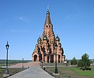 Top-down, left-to-right: City gate sign; Lesosibirsk railway station; Krestovozdvigenskiy orthodox temple | |
 Flag  Coat of arms | |
Location of Lesosibirsk .mw-parser-output .locmap .od{position:absolute}.mw-parser-output .locmap .id{position:absolute;line-height:0}.mw-parser-output .locmap .l0{font-size:0;position:absolute}.mw-parser-output .locmap .pv{line-height:110%;position:absolute;text-align:center}.mw-parser-output .locmap .pl{line-height:110%;position:absolute;top:-0.75em;text-align:right}.mw-parser-output .locmap .pr{line-height:110%;position:absolute;top:-0.75em;text-align:left}.mw-parser-output .locmap .pv>div{display:inline;padding:1px}.mw-parser-output .locmap .pl>div{display:inline;padding:1px;float:right}.mw-parser-output .locmap .pr>div{display:inline;padding:1px;float:left}html.skin-theme-clientpref-night .mw-parser-output .od,html.skin-theme-clientpref-night .mw-parser-output .od .pv>div,html.skin-theme-clientpref-night .mw-parser-output .od .pl>div,html.skin-theme-clientpref-night .mw-parser-output .od .pr>div{background:#000;color:#fff}html.skin-theme-clientpref-night .mw-parser-output .locmap{filter:grayscale(0.6)}@media(prefers-color-scheme:dark){html.skin-theme-clientpref-os .mw-parser-output .locmap{filter:grayscale(0.6)}html.skin-theme-clientpref-os .mw-parser-output .od,html.skin-theme-clientpref-os .mw-parser-output .od .pv>div,html.skin-theme-clientpref-os .mw-parser-output .od .pl>div,html.skin-theme-clientpref-os .mw-parser-output .od .pr>div{background:#000;color:#fff}}  Lesosibirsk Location of Lesosibirsk 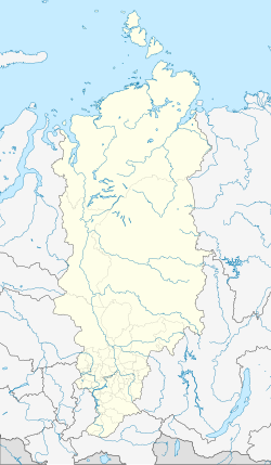 Lesosibirsk Lesosibirsk (Krasnoyarsk Krai) | |
| Coordinates: 58°14′09″N 92°28′58″E / 58.23583°N 92.48278°E | |
| Country | Russia |
| Federal subject | Krasnoyarsk Krai[1] |
| Founded | February 21, 1975[2] |
| Town status since | February 21, 1975[2] |
| Elevation | 80 m (260 ft) |
| Population | |
| • Total | 61,139 |
| • Estimate (2018)[4] | 59,525 (−2.6%) |
| • Rank | 266th in 2010 |
| • Subordinated to | krai town of Lesosibirsk[1] |
| • Capital of | krai town of Lesosibirsk[1] |
| • Urban okrug | Lesosibirsk Urban Okrug[5] |
| • Capital of | Lesosibirsk Urban Okrug[5] |
| Time zone | UTC+7 (MSK+4 |
| Postal code(s)[7] | 662540, 662541, 662543, 662544, 662546–662549 |
| Dialing code(s) | +7 39145 |
| OKTMO ID | 04722000001 |
| Website | lesosibirsk |
History edit

The village of Maklakov Lug (Russian: Маклаков Луг), later known as Maklakovo (Маклаково) existed on the territory of modern Lesosibirsk since 1640. In the early 20th century, Norwegian industrialist Jonas Lied established a wood processing plant here. The plant was nationalized after the revolution. After World War II, large wood-processing plants were built here. The Achinsk–Maklakovo railway connected the area with the Siberian Railway. Two new settlements, Novomaklakovo and Novoyeniseysk were built in the area. On February 21, 1975, the settlements of Maklakovo and Novomaklakovo were merged into the new town of Lesosibirsk.[2] The settlement of Novoyeniseysk was merged into Lesosibirsk in 1989.
Demographics edit
| Year | Pop. | ±% |
|---|---|---|
| 1970 | 65,539 | — |
| 1979 | 65,229 | −0.5% |
| 1989 | 64,842 | −0.6% |
| 2002 | 64,697 | −0.2% |
| 2009 | 64,477 | −0.3% |
| 2010 | 64,323 | −0.2% |
| 2012 | 64,092 | −0.4% |
| 2013 | 50,064 | −21.9% |
| 2014 | 70,457 | +40.7% |
| 2015 | 82,071 | +16.5% |
| 2016 | 71,141 | −13.3% |
| 2018 | 66,240 | −6.9% |
| 2019 | 65,916 | −0.5% |
| 2020 | 63,995 | −2.9% |
Administrative and municipal status edit
Within the framework of administrative divisions, it is, together with the urban-type settlement of Strelka and one rural locality (the settlement of Ust-Angarsk), incorporated as the krai town of Lesosibirsk—an administrative unit with the status equal to that of the districts.[1] As a municipal division, the krai town of Lesosibirsk is incorporated as Lesosibirsk Urban Okrug.[5]
References edit
Notes edit
- ^ a b c d e Law #10-4765
- ^ a b c "General Information" (in Russian). Retrieved March 21, 2018.
- ^ a b Russian Federal State Statistics Service (2011). Всероссийская перепись населения 2010 года. Том 1 [2010 All-Russian Population Census, vol. 1]. Всероссийская перепись населения 2010 года [2010 All-Russia Population Census] (in Russian). Federal State Statistics Service.
- ^ "26. Численность постоянного населения Российской Федерации по муниципальным образованиям на 1 января 2018 года". Federal State Statistics Service. Retrieved January 23, 2019.
- ^ a b c "Закон Красноярского края от 25.02.2005 N 13-3128 "О наделении муниципального образования город Лесосибирск статусом городского округа" (с изменениями и дополнениями) | ГАРАНТ" (in Russian). Retrieved November 20, 2021.
- ^ "Об исчислении времени". Официальный интернет-портал правовой информации (in Russian). June 3, 2011. Retrieved January 19, 2019.
- ^ Почта России. Информационно-вычислительный центр ОАСУ РПО. (Russian Post). Поиск объектов почтовой связи (Postal Objects Search) (in Russian)
- ^ Federal State Statistics Service (May 21, 2004). Численность населения России, субъектов Российской Федерации в составе федеральных округов, районов, городских поселений, сельских населённых пунктов – районных центров и сельских населённых пунктов с населением 3 тысячи и более человек [Population of Russia, Its Federal Districts, Federal Subjects, Districts, Urban Localities, Rural Localities—Administrative Centers, and Rural Localities with Population of Over 3,000] (XLS). Всероссийская перепись населения 2002 года [All-Russia Population Census of 2002] (in Russian).
- ^ Всесоюзная перепись населения 1989 г. Численность наличного населения союзных и автономных республик, автономных областей и округов, краёв, областей, районов, городских поселений и сёл-райцентров [All Union Population Census of 1989: Present Population of Union and Autonomous Republics, Autonomous Oblasts and Okrugs, Krais, Oblasts, Districts, Urban Settlements, and Villages Serving as District Administrative Centers]. Всесоюзная перепись населения 1989 года [All-Union Population Census of 1989] (in Russian). Институт демографии Национального исследовательского университета: Высшая школа экономики [Institute of Demography at the National Research University: Higher School of Economics]. 1989 – via Demoscope Weekly.
Sources edit
- Законодательное собрание Красноярского края. Закон №10-4765 от 10 июня 2010 г. «О перечне административно-территориальных единиц и территориальных единиц Красноярского края», в ред. Закона №7-3007 от 16 декабря 2014 г. «Об изменении административно-территориального устройства Большеулуйского района и о внесении изменений в Закон края "О перечне административно-территориальных единиц и территориальных единиц Красноярского края"». Вступил в силу 1 июля 2010 г. Опубликован: "Ведомости высших органов государственной власти Красноярского края", №33(404), 5 июля 2010 г. (Legislative Assembly of Krasnoyarsk Krai. Law #10-4765 of June 10, 2010 On the Registry of the Administrative-Territorial Units and the Territorial Units of Krasnoyarsk Krai, as amended by the Law #7-3007 of December 16, 2014 On Changing the Administrative-Territorial Structure of Bolsheuluysky District and on Amending the Krai Law "On the Registry of the Administrative-Territorial Units and the Territorial Units of Krasnoyarsk Krai". Effective as of July 1, 2010.).
- Законодательное собрание Красноярского края. Закон №13-3128 от 25 февраля 2005 г. «О наделении муниципального образования город Лесосибирск статусом городского округа», в ред. Закона №5-1826 от 21 ноября 2013 г. «О внесении изменений в Законы края об установлении границ и наделении соответствующим статусом муниципальных образований Красноярского края». Вступил в силу через десять дней после официального опубликования. Опубликован: "Ведомости высших органов государственной власти Красноярского края", №11, 20 марта 2005 г. (Legislative Assembly of Krasnoyarsk Krai. Law #13-3128 of February 25, 2005 On Granting Urban Okrug Status to the Municipal Formation of the Town of Lesosibirsk, as amended by the Law #5-1826 of November 21, 2013 On Amending the Krai Laws on Establishing the Borders and Granting an Appropriate Status to the Municipal Formations of Krasnoyarsk Krai. Effective as of the day ten days after the official publication.).