


Summary
Lewis Bay is a bay indenting the north coast of Ross Island, Antarctica, between Mount Bird and Cape Tennyson.[1]
| Lewis Bay | |
|---|---|
 Lewis Bay | |
| Location | Ross Island, Antarctica |
| Coordinates | 77°20′S 167°31′E / 77.333°S 167.517°E |
| Basin countries | Antarctica |
History edit
The bay was charted by the British National Antarctic Expedition under Robert Falcon Scott, 1901–04. It was named by the Advisory Committee on Antarctic Names in 1964 for Captain Price Lewis, commanding officer of the USS Staten Island (AGB-5) during the US Navy's Operation Deep Freeze in 1959, and who in 1963 and 1964 was assistant chief of staff and ship group commander of the United States Naval Support Force in Antarctica.[2]
Air crash edit
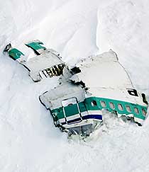
On 28 November 1979 an Air New Zealand aircraft carrying 257 people on a sightseeing flight to Antarctica crashed on the side of Mount Erebus, killing everyone aboard and scattering bodies and aircraft debris on the slopes above the bay. Not all the bodies were subsequently recovered.[3]
Antarctic Specially Protected Area edit
An area above Lewis Bay, on the lower slopes of Mount Erebus and extending to the coast, is protected as Antarctic Specially Protected Area No.156 because it has been declared a tomb in order to ensure that the area be left in peace. The declaration was made as a mark of respect and sympathy with the relatives of those who died in the 1979 crash, and with the Government and people of New Zealand, in remembrance and in order to protect the site's emotional values.[3]
Historic site edit
A stainless steel cross was erected in January 1987 on a rocky promontory 3 km from the 1979 crash site as a mark of respect and in remembrance of those who died. The cross has been designated a Historic Site or Monument (HSM 73), following a proposal by New Zealand to the Antarctic Treaty Consultative Meeting.[4]
Features edit
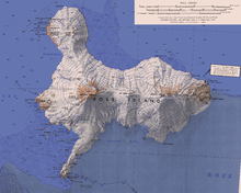
Cape Tennyson edit
77°22′S 168°18′E / 77.367°S 168.300°E. A rock cape on the north coast of Ross Island, about 25 nautical miles (46 km; 29 mi) southeast of Cape Bird. Discovered in February 1900 by the British Antarctic Expedition, 1898–1900 under Carsten Borchgrevink, and named by him for English poet Alfred, Lord Tennyson.[5]
Wyandot Point edit
77°23′00″S 168°04′00″E / 77.3833333°S 168.0666667°E. A rock point 3 nautical miles (5.6 km; 3.5 mi) west-southwest of Cape Tennyson on the north side of Ross Island. In association with the names of expedition ships grouped on this island, named after United States Naval Ship (United States NavyS) Wyandot, a transport ship that carried supplies to this area in at least 13 seasons, 1955-56 to 1971-72.[6]
References edit
- ^ Alberts 1995, p. 430.
- ^ Alberts 1995, pp. 430–431.
- ^ a b "Lewis Bay, Mount Erebus, Ross Island" (PDF). Management Plan for Antarctic Specially Protected Area No. 156: Measure 2, Annex. Antarctic Treaty Secretariat. 2003. Retrieved 2013-03-12.
- ^ "List of Historic Sites and Monuments approved by the ATCM (2012)" (PDF). Antarctic Treaty Secretariat. 2012. Retrieved 2014-01-06.
- ^ Alberts 1995, p. 738.
- ^ Wyandot Point USGS.
Sources edit
- Alberts, Fred G., ed. (1995), Geographic Names of the Antarctic (PDF) (2 ed.), United States Board on Geographic Names, retrieved 2024-01-30
 This article incorporates public domain material from websites or documents of the United States Board on Geographic Names.
 - "Wyandot Point", Geographic Names Information System, United States Geological Survey, United States Department of the Interior
![]() This article incorporates public domain material from websites or documents of the United States Geological Survey.
This article incorporates public domain material from websites or documents of the United States Geological Survey.