


Summary
Lewis Township is a township that is located in Northumberland County, Pennsylvania, United States. The population at the time of the 2010 Census was 1,915,[3] an increase over the figure of 1,862 that was tabulated in 2000.
Lewis Township, Northumberland County, Pennsylvania | |
|---|---|
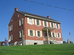 The Hower-Slote House is on the National Register of Historic Places and was built on the site of Fort Freeland (destroyed 1779) | |
 Map of Northumberland County, Pennsylvania highlighting Lewis Township | |
 Map of Northumberland County, Pennsylvania | |
| Country | United States |
| State | Pennsylvania |
| County | Northumberland |
| Settled | 1773 |
| Incorporated | 1843 |
| Government | |
| • Type | Board of Supervisors |
| Area | |
| • Total | 26.41 sq mi (68.39 km2) |
| • Land | 26.38 sq mi (68.33 km2) |
| • Water | 0.03 sq mi (0.06 km2) |
| Population (2010) | |
| • Total | 1,915 |
| • Estimate (2016)[2] | 1,911 |
| • Density | 72.44/sq mi (27.97/km2) |
| Time zone | UTC-5 (Eastern (EST)) |
| • Summer (DST) | UTC-4 (EDT) |
| Area code | 570 |
| FIPS code | 42-097-42952 |
History edit
The Hower-Slote House was listed on the National Register of Historic Places in 1979.[4]
Geography edit

According to the United States Census Bureau, the township has a total area of 26.4 square miles (68.3 km2), all land.
Demographics edit
| Census | Pop. | Note | %± |
|---|---|---|---|
| 2010 | 1,915 | — | |
| 2016 (est.) | 1,911 | [2] | −0.2% |
| U.S. Decennial Census[5] | |||
As of the census[6] of 2000, there were 1,862 people, 636 households, and 550 families residing in the township.
The population density was 70.6 inhabitants per square mile (27.3/km2). There were 663 housing units at an average density of 25.1/sq mi (9.7/km2).
The racial makeup of the township was 99.36% White, 0.16% African American, 0.05% Native American, 0.16% Asian, 0.05% from other races, and 0.21% from two or more races. Hispanic or Latino of any race were 0.21% of the population.
There were 636 households, out of which 36.5% had children under the age of eighteen living with them; 79.1% were married couples living together, 3.6% had a female householder with no husband present, and 13.4% were non-families. 11.6% of all households were made up of individuals, and 6.0% had someone living alone who was sixty-five years of age or older.
The average household size was 2.89, and the average family size was 3.11.
Within the township, the population was spread out, with 25.7% of residents who were under the age of eighteen, 7.9% who were aged eighteen to twenty-four, 26.0% who were aged twenty-five to forty-four, 28.3% who were aged forty-five to sixty-four, and 12.0% who were sixty-five years of age or older. The median age was thirty-nine years.
For every one hundred females, there were 103.9 males. For every one hundred females who were aged eighteen or older, there were 101.0 males.
The median income for a household in the township was $41,406, and the median income for a family was $44,922. Males had a median income of $32,101 compared with that of $21,767 for females.
The per capita income for the township was $16,876.
Approximately 3.9% of families and 7.6% of the population were living below the poverty line, including 14.4% of those who were under the age of eighteen and 5.6% of those who were aged sixty-five or older.
References edit
- ^ "2016 U.S. Gazetteer Files". United States Census Bureau. Retrieved August 14, 2017.
- ^ a b "Population and Housing Unit Estimates". Retrieved June 9, 2017.
- ^ "Geographic Identifiers: 2010 Demographic Profile Data (G001): Lewis Township, Northumberland County, Pennsylvania". U.S. Census Bureau, American Factfinder. Archived from the original on February 12, 2020. Retrieved August 22, 2016.
- ^ "National Register Information System". National Register of Historic Places. National Park Service. July 9, 2010.
- ^ "Census of Population and Housing". Census.gov. Retrieved June 4, 2016.
- ^ "U.S. Census website". United States Census Bureau. Retrieved January 31, 2008.
41°08′00″N 76°43′59″W / 41.13333°N 76.73306°W