
KNOWPIA
WELCOME TO KNOWPIA

Lievegem 
Summary
Lievegem (Dutch pronunciation: [ˈlivəˌɣɛm] ⓘ) is a municipality in the Belgian province of East Flanders that arose on 1 January 2019 from the merging of the municipalities of Waarschoot, Lovendegem and Zomergem.[2]
Lievegem | |
|---|---|
 | |
 Flag  Coat of arms | |
Location of Lievegem .mw-parser-output .locmap .od{position:absolute}.mw-parser-output .locmap .id{position:absolute;line-height:0}.mw-parser-output .locmap .l0{font-size:0;position:absolute}.mw-parser-output .locmap .pv{line-height:110%;position:absolute;text-align:center}.mw-parser-output .locmap .pl{line-height:110%;position:absolute;top:-0.75em;text-align:right}.mw-parser-output .locmap .pr{line-height:110%;position:absolute;top:-0.75em;text-align:left}.mw-parser-output .locmap .pv>div{display:inline;padding:1px}.mw-parser-output .locmap .pl>div{display:inline;padding:1px;float:right}.mw-parser-output .locmap .pr>div{display:inline;padding:1px;float:left}html.skin-theme-clientpref-night .mw-parser-output .od,html.skin-theme-clientpref-night .mw-parser-output .od .pv>div,html.skin-theme-clientpref-night .mw-parser-output .od .pl>div,html.skin-theme-clientpref-night .mw-parser-output .od .pr>div{background:#000;color:#fff}html.skin-theme-clientpref-night .mw-parser-output .locmap{filter:grayscale(0.6)}@media(prefers-color-scheme:dark){html.skin-theme-clientpref-os .mw-parser-output .locmap{filter:grayscale(0.6)}html.skin-theme-clientpref-os .mw-parser-output .od,html.skin-theme-clientpref-os .mw-parser-output .od .pv>div,html.skin-theme-clientpref-os .mw-parser-output .od .pl>div,html.skin-theme-clientpref-os .mw-parser-output .od .pr>div{background:#000;color:#fff}}  Lievegem Location in Belgium
Location of the municipality of Lievegem  | |
| Coordinates: 51°08′N 3°35′E / 51.13°N 3.58°E | |
| Country | |
| Community | Flemish Community |
| Region | Flemish Region |
| Province | East Flanders |
| Arrondissement | Ghent |
| Government | |
| • Mayor | Kim Martens (CD&V) |
| • Governing party/ies | CD&V, Open VLD |
| Area | |
| • Total | 80.78 km2 (31.19 sq mi) |
| Population (2022-01-01)[1] | |
| • Total | 26,657 |
| • Density | 330/km2 (850/sq mi) |
| Postal codes | 9920, 9921, 9930, 9931, 9932, 9950 |
| NIS code | 44085 |
| Area codes | 09 |
| Website | www.lievegem.be |
The merged municipality has an area of 80.78 km2 and is home to 26,441 inhabitants as of 2021.[3] A referendum was held for the new name of the municipality, and 55% voted for Lievegem (literally Lieve Canal settlement).[4]
Lievegem consists of the following deelgemeentes (sub-municipalities): Lovendegem, Oostwinkel, Ronsele, Vinderhoute, Waarschoot, and Zomergem.[5]
Gallery edit
-
 St. Martin's church in Zomergem
 -
 Brewery in Beke
 -
 Rectory in Zomergem
 -
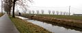 The Lieve Canal


References edit
- ^ "Bevolking per gemeente op 1 januari 2022". Statbel.
- ^ "Drie kleintjes zijn liever samen groot: in 2019 worden inwoners wakker in Lievegem". Nieuwsblad (in Dutch). Retrieved 5 May 2022.
- ^ "Bevolking per statistische sector - Sector 44036". Statistics Belgium. Retrieved 5 May 2022.
- ^ "Lovendegem, Zomergem en Waarschoot smelten samen tot Lievegem". Vlaamse Radio- en Televisieomroeporganisatie (in Dutch). Retrieved 5 May 2022.
- ^ "Lievegem". Vlaanderen.be (in Dutch). Retrieved 5 May 2022.
External links edit
 Media related to Lievegem at Wikimedia Commons
- Official site