


Summary
Lillesand is the administrative centre of Lillesand municipality in Agder county, Norway. The town is located along the Skagerak coast, about 18 kilometres (11 mi) southwest of the town of Grimstad and about 25 kilometres (16 mi) northeast of the city of Kristiansand. The 5.08-square-kilometre (1,260-acre) town has a population (2019) of 7,966 and a population density of 1,567 inhabitants per square kilometre (4,060/sq mi).[1] In Norway, Lillesand is considered a by which can be translated as either a "town" or "city" in English.
Lillesand | |
|---|---|
 View of the town harbour | |
 Lillesand Location of the town  Lillesand Lillesand (Norway) | |
| Coordinates: 58°14′58″N 8°22′38″E / 58.2495°N 08.3772°E | |
| Country | Norway |
| Region | Southern Norway |
| County | Agder |
| Municipality | Lillesand |
| Established as | |
| Ladested | 1821-1961 |
| Town (By) | Since 1996 |
| Area | |
| • Total | 5.08 km2 (1.96 sq mi) |
| Elevation | 8 m (26 ft) |
| Population (2019)[1] | |
| • Total | 7,966 |
| • Density | 1,567/km2 (4,060/sq mi) |
| Time zone | UTC+01:00 (CET) |
| • Summer (DST) | UTC+02:00 (CEST) |
| Post Code | 4790 Lillesand |
Lillesand Church is located in the town and it is the seat of the Vest-Nedenes prosti (deanery). The European route E18 passes by the town, one of the main roads along southeastern Norway. The Blindleia strait is an inland waterway that leads from the Høvåg area northwards to the town of Lillesand.
History edit
The village of Lillesand grew up significantly during the 17th century around its natural harbour. In 1821, the village area was granted the status as a ladested (a sea port with special trading rights). In 1838, the new formannskapsdistrikt law established each parish in Norway as a self-governing local municipality and each ladested was separate from its surrounding parish. This meant that Lillesand became self-governing like the new civil municipalities. Later, in 1952, the town became classified as a bykommune (town-municipality).
During the 1960s, there were many municipal mergers across Norway due to the work of the Schei Committee. On 1 January 1962, the town of Lillesand (population: 1,041) was merged with the neighboring municipalities of Høvåg (population: 1,330) and Vestre Moland (population: 2,454) and the Gitmark farm area (population: 22) in the neighboring municipality of Eide. Together, this new municipality was called Lillesand, but it lost is status as a bykommune (town) because of this merger. In 1996, the law changed and this enabled the municipal council of Lillesand to declare town status for Lillesand once again.[3][4][5]
Media gallery edit

-
 Standgata
 -
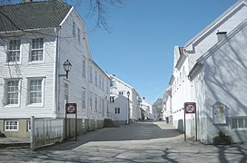 Øvre gate
 -
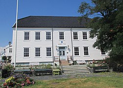 The town hall, Henschiengården
 -
 The old customs house
 -
 The museum at Carl Knudsen-gården


See also edit
References edit
- ^ a b c Statistisk sentralbyrå (1 January 2019). "Urban settlements. Population and area, by municipality".
- ^ "Lillesand (Aust-Agder)". yr.no. Archived from the original on 2017-08-03. Retrieved 2017-09-06.
- ^ Thorsnæs, Geir, ed. (2016-04-05). "Lillesand". Store norske leksikon (in Norwegian). Kunnskapsforlaget. Retrieved 2017-09-06.
- ^ Jukvam, Dag (1999). "Historisk oversikt over endringer i kommune- og fylkesinndelingen" (PDF) (in Norwegian). Statistisk sentralbyrå.
- ^ Bakke, Tor Malvin. "Byhistorie" (in Norwegian). Retrieved 2017-09-06.
External links edit
 Media related to Lillesand at Wikimedia Commons
 Lillesand travel guide from Wikivoyage